
 Search
HURRICANE MATTHEW: Phase 2--"The Turn"
Page 1 of 40 • 1, 2, 3 ... 20 ... 40 ![]()

HURRICANE MATTHEW: Phase 2--"The Turn"
![]() by sroc4 Sat Oct 01, 2016 7:55 am
by sroc4 Sat Oct 01, 2016 7:55 am


Current steering maps show the weakness is right on the cusp of allowing the turn.
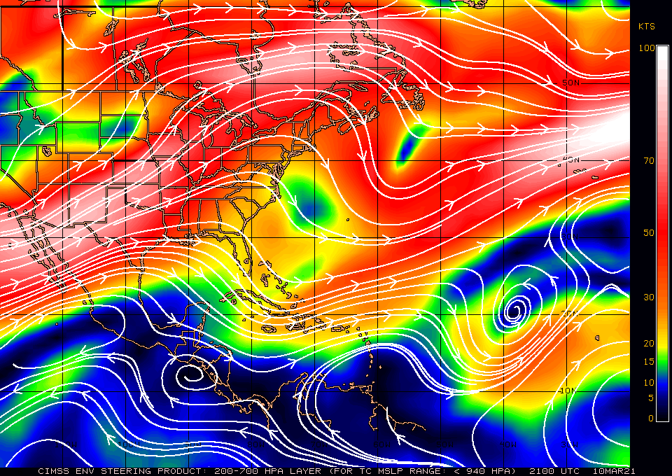
Ive been thinking about a few things here after examining the models this morning. We know its the trough currently in the east that splits and the piece that backs SW into the GOM is what creates the initial weakness in the ridging over the GOM and W Caribbean and will turn Mathew northwest. Once he gets to the edge of the WAR he turns N.

The northern piece of the split we have been monitoring is what we are hoping lifts out NE faster so it doesn't lead to the weakness in the Atlantic and the OTS recurve. A faster exiting ULL in the NE allows the WAR to build back and the "ridge bridge" can develop blocking the recurve and allowing time for the approaching trough from the west to capture it. We have been focusing on ULL in the NE and its timing and strength as a key to this and rightfully so, but I believe the southern piece of the split trough and how intimately linked it is to our system, may hold the key. Models still differ on this.

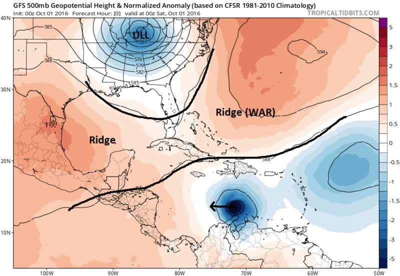
Almost a year ago to the day, when examining what happened with Joaquin we remained focused on the idea that the big ULL in the SE was going to be the dominant feature that would pick him up and swing him into the coast. However it ended up being this small seemingly innocuous ULL out in the Atlantic that ended up being the most important piece to the puzzle. This seemingly B-9 looking feature in the Atlantic held onto Joaquin just long enough to keep it far enough away from a full capture by the ULL and the block had a chance to break down and out he went. See the full blog here: https://www.njstrongweatherforum.com/t585-a-discussion-on-the-track-of-major-hurricane-joaquin-oct-2nd-2015#67922
 " />
" /> So where am I going with this? To understand lets look at a few more frames from last nights GFS 00z. I believe that the trough retrograding SW through the GOM and into central America has an almost Fujiwhara effect on our system, holding onto it, and slinging it in closer to the coast (at least modeled here). Now typically a true Fujiwhara effect involves the interactions between two tropical systems in close proximity to each other. (http://www.hko.gov.hk/education/edu01met/wxphe/ele_fujiwhara_e.htm) But when looking at how this is modeled, esp on the GFS, there is a clear focal point along an axis at which the two interact before Mathew breaks away and gets captured by the trough.
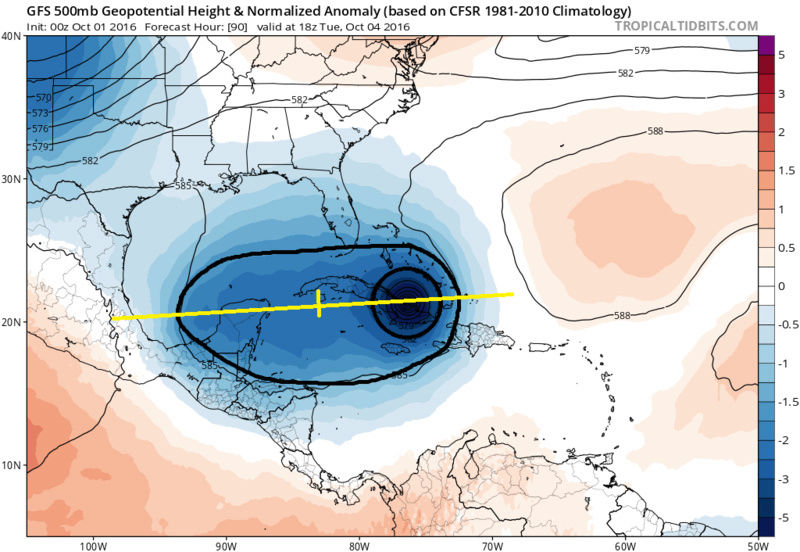
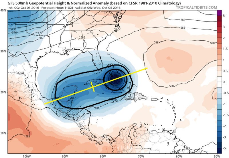
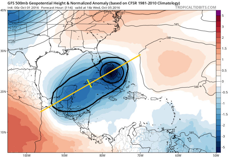
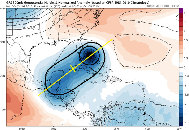
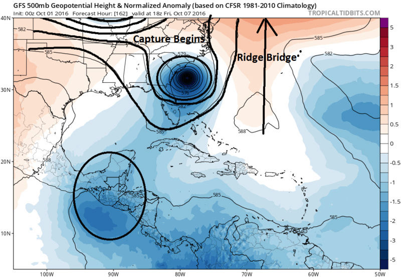
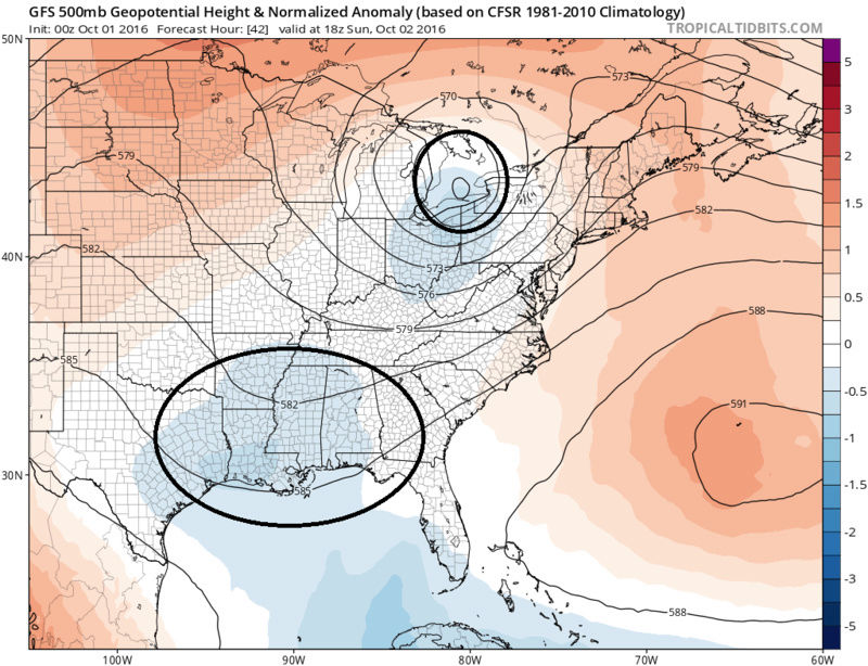
How long can this feature hold onto Mathew before he becomes influenced by the other players? I believe the longer and stronger these two pieces "dance" the more time the WAR and N ridge can build their bridge trapping Mathew. Then of course the final piece to the puzzle is how deep, and what kind of trough axis is there when it approaches from the west, and what kind of capture, if any occurs? There are still vast differences in how strong this interaction is between GFS and Euro. Euro breaks away very quickly because it has the ULL weaker, and the track further east than the GFS coming out of the Caribbean. Its been said many many times, but I feel it necessary now more than ever, we still have a lot to get through before we know the final outcome, try not to hang your hat on any one soln just yet.
WE TRACK!!!

Last edited by sroc4 on Sat Oct 01, 2016 8:32 am; edited 1 time in total
_________________
"In weather and in life, there's no winning and losing; there's only winning and learning."
WINTER 2012/2013 TOTALS 43.65"WINTER 2017/2018 TOTALS 62.85" WINTER 2022/2023 TOTALS 4.9"
WINTER 2013/2014 TOTALS 64.85"WINTER 2018/2019 TOTALS 14.25" WINTER 2023/2024 TOTALS 13.1"
WINTER 2014/2015 TOTALS 71.20"WINTER 2019/2020 TOTALS 6.35"
WINTER 2015/2016 TOTALS 35.00"WINTER 2020/2021 TOTALS 37.75"
WINTER 2016/2017 TOTALS 42.25"WINTER 2021/2022 TOTALS 31.65"

sroc4- Admin

- Posts : 8331
Reputation : 301
Join date : 2013-01-07
Location : Wading River, LI
Re: HURRICANE MATTHEW: Phase 2--"The Turn"
![]() by NjWeatherGuy Sat Oct 01, 2016 8:15 am
by NjWeatherGuy Sat Oct 01, 2016 8:15 am

NjWeatherGuy- Advanced Forecaster

- Posts : 4100
Reputation : 28
Join date : 2013-01-06
Location : Belle Mead, NJ
Re: HURRICANE MATTHEW: Phase 2--"The Turn"
![]() by NjWeatherGuy Sat Oct 01, 2016 8:21 am
by NjWeatherGuy Sat Oct 01, 2016 8:21 am
NjWeatherGuy- Advanced Forecaster
- Posts : 4100
Reputation : 28
Join date : 2013-01-06
Location : Belle Mead, NJ
Re: HURRICANE MATTHEW: Phase 2--"The Turn"
![]() by skinsfan1177 Sat Oct 01, 2016 8:24 am
by skinsfan1177 Sat Oct 01, 2016 8:24 am
NjWeatherGuy wrote:FWIW the 6z GFDL has the storm at its deepest, 921mb, off the Carolina coast moving north about to run into the block with a strong east-south-easterly flow into the coast, not good. This is really going to be a long week....
Yes a long week what's not good?

skinsfan1177- Senior Enthusiast

- Posts : 4485
Reputation : 35
Join date : 2013-01-07
Age : 46
Location : Point Pleasant Boro
Re: HURRICANE MATTHEW: Phase 2--"The Turn"
![]() by NjWeatherGuy Sat Oct 01, 2016 8:37 am
by NjWeatherGuy Sat Oct 01, 2016 8:37 am
http://www.tropicaltidbits.com/analysis/models/?model=gfdl-p®ion=14L&pkg=mslp_wind&runtime=2016100106&fh=102&xpos=0&ypos=24
NjWeatherGuy- Advanced Forecaster
- Posts : 4100
Reputation : 28
Join date : 2013-01-06
Location : Belle Mead, NJ
Re: HURRICANE MATTHEW: Phase 2--"The Turn"
![]() by weatherwatchermom Sat Oct 01, 2016 9:09 am
by weatherwatchermom Sat Oct 01, 2016 9:09 am
http://www.tropicaltidbits.com/analysis/models/?model=gfdl-p®ion=14L&pkg=mslp_wind&runtime=2016100106&fh=102&xpos=0&ypos=24[/quote
Top 10
https://weather.com/storms/hurricane/news/strongest-hurricanes-most-intense-atlantic-hurricanes-20130911#/10

weatherwatchermom- Senior Enthusiast
- Posts : 3734
Reputation : 77
Join date : 2014-11-25
Age : 60
Location : Hazlet Township, NJ
Re: HURRICANE MATTHEW: Phase 2--"The Turn"
![]() by Frank_Wx Sat Oct 01, 2016 9:20 am
by Frank_Wx Sat Oct 01, 2016 9:20 am
His short term track is key.
_________________
_______________________________________________________________________________________________________
CLICK HERE to view NJ Strong Snowstorm Classifications

Frank_Wx- Godzilla Seeker
- Posts : 21305
Reputation : 328
Join date : 2013-01-05
Age : 31
Location : Jersey City, NJ -

Re: HURRICANE MATTHEW: Phase 2--"The Turn"
![]() by Frank_Wx Sat Oct 01, 2016 9:23 am
by Frank_Wx Sat Oct 01, 2016 9:23 am
_________________
_______________________________________________________________________________________________________
CLICK HERE to view NJ Strong Snowstorm Classifications
Frank_Wx- Godzilla Seeker
- Posts : 21305
Reputation : 328
Join date : 2013-01-05
Age : 31
Location : Jersey City, NJ -
Re: HURRICANE MATTHEW: Phase 2--"The Turn"
![]() by Frank_Wx Sat Oct 01, 2016 9:36 am
by Frank_Wx Sat Oct 01, 2016 9:36 am

_________________
_______________________________________________________________________________________________________
CLICK HERE to view NJ Strong Snowstorm Classifications
Frank_Wx- Godzilla Seeker
- Posts : 21305
Reputation : 328
Join date : 2013-01-05
Age : 31
Location : Jersey City, NJ -
Re: HURRICANE MATTHEW: Phase 2--"The Turn"
![]() by sroc4 Sat Oct 01, 2016 9:45 am
by sroc4 Sat Oct 01, 2016 9:45 am
Frank_Wx wrote:Observations show Matthew slowing down, slightly weakening, and could be turning more north than northwest. If true, EURO could be correct with track.
I'm not sure I see much of a turn NW yet Frank. Maybe slight N of W at the end of the loop. But it also could be because likely the eye wall is getting restructured. What is that called again?
_________________
"In weather and in life, there's no winning and losing; there's only winning and learning."
WINTER 2012/2013 TOTALS 43.65"WINTER 2017/2018 TOTALS 62.85" WINTER 2022/2023 TOTALS 4.9"
WINTER 2013/2014 TOTALS 64.85"WINTER 2018/2019 TOTALS 14.25" WINTER 2023/2024 TOTALS 13.1"
WINTER 2014/2015 TOTALS 71.20"WINTER 2019/2020 TOTALS 6.35"
WINTER 2015/2016 TOTALS 35.00"WINTER 2020/2021 TOTALS 37.75"
WINTER 2016/2017 TOTALS 42.25"WINTER 2021/2022 TOTALS 31.65"
sroc4- Admin
- Posts : 8331
Reputation : 301
Join date : 2013-01-07
Location : Wading River, LI
Re: HURRICANE MATTHEW: Phase 2--"The Turn"
![]() by sroc4 Sat Oct 01, 2016 9:47 am
by sroc4 Sat Oct 01, 2016 9:47 am
_________________
"In weather and in life, there's no winning and losing; there's only winning and learning."
WINTER 2012/2013 TOTALS 43.65"WINTER 2017/2018 TOTALS 62.85" WINTER 2022/2023 TOTALS 4.9"
WINTER 2013/2014 TOTALS 64.85"WINTER 2018/2019 TOTALS 14.25" WINTER 2023/2024 TOTALS 13.1"
WINTER 2014/2015 TOTALS 71.20"WINTER 2019/2020 TOTALS 6.35"
WINTER 2015/2016 TOTALS 35.00"WINTER 2020/2021 TOTALS 37.75"
WINTER 2016/2017 TOTALS 42.25"WINTER 2021/2022 TOTALS 31.65"
sroc4- Admin
- Posts : 8331
Reputation : 301
Join date : 2013-01-07
Location : Wading River, LI
Re: HURRICANE MATTHEW: Phase 2--"The Turn"
![]() by Frank_Wx Sat Oct 01, 2016 9:50 am
by Frank_Wx Sat Oct 01, 2016 9:50 am
sroc4 wrote:Frank_Wx wrote:Observations show Matthew slowing down, slightly weakening, and could be turning more north than northwest. If true, EURO could be correct with track.
I'm not sure I see much of a turn NW yet Frank. Maybe slight N of W at the end of the loop. But it also could be because likely the eye wall is getting restructured. What is that called again?
That's a much better animation than what I saw on Twitter. Yeah, still looks more west. Good.
Eyewall replacement cycle
_________________
_______________________________________________________________________________________________________
CLICK HERE to view NJ Strong Snowstorm Classifications
Frank_Wx- Godzilla Seeker
- Posts : 21305
Reputation : 328
Join date : 2013-01-05
Age : 31
Location : Jersey City, NJ -
Re: HURRICANE MATTHEW: Phase 2--"The Turn"
![]() by sroc4 Sat Oct 01, 2016 9:51 am
by sroc4 Sat Oct 01, 2016 9:51 am
Frank_Wx wrote:sroc4 wrote:Frank_Wx wrote:Observations show Matthew slowing down, slightly weakening, and could be turning more north than northwest. If true, EURO could be correct with track.
I'm not sure I see much of a turn NW yet Frank. Maybe slight N of W at the end of the loop. But it also could be because likely the eye wall is getting restructured. What is that called again?
That's a much better animation than what I saw on Twitter. Yeah, still looks more west. Good.
Eyewall replacement cycle
That's right ERC. UKMET on day 7:
_________________
"In weather and in life, there's no winning and losing; there's only winning and learning."
WINTER 2012/2013 TOTALS 43.65"WINTER 2017/2018 TOTALS 62.85" WINTER 2022/2023 TOTALS 4.9"
WINTER 2013/2014 TOTALS 64.85"WINTER 2018/2019 TOTALS 14.25" WINTER 2023/2024 TOTALS 13.1"
WINTER 2014/2015 TOTALS 71.20"WINTER 2019/2020 TOTALS 6.35"
WINTER 2015/2016 TOTALS 35.00"WINTER 2020/2021 TOTALS 37.75"
WINTER 2016/2017 TOTALS 42.25"WINTER 2021/2022 TOTALS 31.65"
sroc4- Admin
- Posts : 8331
Reputation : 301
Join date : 2013-01-07
Location : Wading River, LI
Re: HURRICANE MATTHEW: Phase 2--"The Turn"
![]() by Frank_Wx Sat Oct 01, 2016 9:53 am
by Frank_Wx Sat Oct 01, 2016 9:53 am
_________________
_______________________________________________________________________________________________________
CLICK HERE to view NJ Strong Snowstorm Classifications
Frank_Wx- Godzilla Seeker
- Posts : 21305
Reputation : 328
Join date : 2013-01-05
Age : 31
Location : Jersey City, NJ -
Re: HURRICANE MATTHEW: Phase 2--"The Turn"
![]() by jmanley32 Sat Oct 01, 2016 9:57 am
by jmanley32 Sat Oct 01, 2016 9:57 am
The added a extra day just for fun? LOL Red flag in what respect, that the Euro may be wrong? The UKMET does come more in line with the GFS so does NAVGEM. Euro is really on its own.Frank_Wx wrote:Wait, UKMET should not have a Day 7. BUT, if that's right, major disagreement with EURO. Red flag.

jmanley32- Senior Enthusiast
- Posts : 20513
Reputation : 108
Join date : 2013-12-12
Age : 42
Location : Yonkers, NY
Re: HURRICANE MATTHEW: Phase 2--"The Turn"
![]() by sroc4 Sat Oct 01, 2016 10:01 am
by sroc4 Sat Oct 01, 2016 10:01 am
Frank_Wx wrote:Wait, UKMET should not have a Day 7. BUT, if that's right, major disagreement with EURO. Red flag.
Yeah check out this site Frank. Rutgers. Will be usefull in winter
http://ruc.noaa.gov/hfip/tcgen/
_________________
"In weather and in life, there's no winning and losing; there's only winning and learning."
WINTER 2012/2013 TOTALS 43.65"WINTER 2017/2018 TOTALS 62.85" WINTER 2022/2023 TOTALS 4.9"
WINTER 2013/2014 TOTALS 64.85"WINTER 2018/2019 TOTALS 14.25" WINTER 2023/2024 TOTALS 13.1"
WINTER 2014/2015 TOTALS 71.20"WINTER 2019/2020 TOTALS 6.35"
WINTER 2015/2016 TOTALS 35.00"WINTER 2020/2021 TOTALS 37.75"
WINTER 2016/2017 TOTALS 42.25"WINTER 2021/2022 TOTALS 31.65"
sroc4- Admin
- Posts : 8331
Reputation : 301
Join date : 2013-01-07
Location : Wading River, LI
Re: HURRICANE MATTHEW: Phase 2--"The Turn"
![]() by Frank_Wx Sat Oct 01, 2016 10:07 am
by Frank_Wx Sat Oct 01, 2016 10:07 am
_________________
_______________________________________________________________________________________________________
CLICK HERE to view NJ Strong Snowstorm Classifications
Frank_Wx- Godzilla Seeker
- Posts : 21305
Reputation : 328
Join date : 2013-01-05
Age : 31
Location : Jersey City, NJ -
Re: HURRICANE MATTHEW: Phase 2--"The Turn"
![]() by Snow88 Sat Oct 01, 2016 10:28 am
by Snow88 Sat Oct 01, 2016 10:28 am
If it doesn't turn asap, the Euro will be wrong.

Snow88- Senior Enthusiast
- Posts : 2193
Reputation : 4
Join date : 2013-01-09
Age : 35
Location : Brooklyn, NY
Re: HURRICANE MATTHEW: Phase 2--"The Turn"
![]() by skinsfan1177 Sat Oct 01, 2016 10:35 am
by skinsfan1177 Sat Oct 01, 2016 10:35 am
Snow88 wrote:Matthew is still moving west right now at 73 moving towards 74. GFS turns it at 76 and Euro at 74.
If it doesn't turn asap, the Euro will be wrong.
Can you show satellite pic.
skinsfan1177- Senior Enthusiast
- Posts : 4485
Reputation : 35
Join date : 2013-01-07
Age : 46
Location : Point Pleasant Boro
Re: HURRICANE MATTHEW: Phase 2--"The Turn"
![]() by sroc4 Sat Oct 01, 2016 10:48 am
by sroc4 Sat Oct 01, 2016 10:48 am
Frank_Wx wrote:sroc4 wrote:Frank_Wx wrote:Observations show Matthew slowing down, slightly weakening, and could be turning more north than northwest. If true, EURO could be correct with track.
I'm not sure I see much of a turn NW yet Frank. Maybe slight N of W at the end of the loop. But it also could be because likely the eye wall is getting restructured. What is that called again?
That's a much better animation than what I saw on Twitter. Yeah, still looks more west. Good.
Eyewall replacement cycle
_________________
"In weather and in life, there's no winning and losing; there's only winning and learning."
WINTER 2012/2013 TOTALS 43.65"WINTER 2017/2018 TOTALS 62.85" WINTER 2022/2023 TOTALS 4.9"
WINTER 2013/2014 TOTALS 64.85"WINTER 2018/2019 TOTALS 14.25" WINTER 2023/2024 TOTALS 13.1"
WINTER 2014/2015 TOTALS 71.20"WINTER 2019/2020 TOTALS 6.35"
WINTER 2015/2016 TOTALS 35.00"WINTER 2020/2021 TOTALS 37.75"
WINTER 2016/2017 TOTALS 42.25"WINTER 2021/2022 TOTALS 31.65"
sroc4- Admin
- Posts : 8331
Reputation : 301
Join date : 2013-01-07
Location : Wading River, LI
Re: HURRICANE MATTHEW: Phase 2--"The Turn"
![]() by jmanley32 Sat Oct 01, 2016 10:50 am
by jmanley32 Sat Oct 01, 2016 10:50 am
Euro is wrong it's been having to many issues with this storm since b4 he formed. The gfs has been most consistent.Snow88 wrote:Matthew is still moving west right now at 73 moving towards 74. GFS turns it at 76 and Euro at 74.
If it doesn't turn asap, the Euro will be wrong.
jmanley32- Senior Enthusiast
- Posts : 20513
Reputation : 108
Join date : 2013-12-12
Age : 42
Location : Yonkers, NY
Re: HURRICANE MATTHEW: Phase 2--"The Turn"
![]() by jmanley32 Sat Oct 01, 2016 10:56 am
by jmanley32 Sat Oct 01, 2016 10:56 am
jmanley32- Senior Enthusiast
- Posts : 20513
Reputation : 108
Join date : 2013-12-12
Age : 42
Location : Yonkers, NY
Re: HURRICANE MATTHEW: Phase 2--"The Turn"
![]() by jmanley32 Sat Oct 01, 2016 10:58 am
by jmanley32 Sat Oct 01, 2016 10:58 am
jmanley32- Senior Enthusiast
- Posts : 20513
Reputation : 108
Join date : 2013-12-12
Age : 42
Location : Yonkers, NY
Re: HURRICANE MATTHEW: Phase 2--"The Turn"
![]() by jmanley32 Sat Oct 01, 2016 11:01 am
by jmanley32 Sat Oct 01, 2016 11:01 am
jmanley32- Senior Enthusiast
- Posts : 20513
Reputation : 108
Join date : 2013-12-12
Age : 42
Location : Yonkers, NY
Re: HURRICANE MATTHEW: Phase 2--"The Turn"
![]() by weatherwatchermom Sat Oct 01, 2016 11:19 am
by weatherwatchermom Sat Oct 01, 2016 11:19 am
jmanley32 wrote:Well I may b wrong as they have the turn b4 76w. But the lr does not agree with euro. Just curious how many miles is each latitude longitude apart. Like how many hrs will it take to go to 76w at 6mph.
latitde are approx 69 mi apart...longitude varies if I am not mistaken depending how close to equator(farthest apart) and how close to poles(closest).(son just had this for SS last week...)
http://www.stevemorse.org/nearest/distance.php found this site might help you calculate
weatherwatchermom- Senior Enthusiast
- Posts : 3734
Reputation : 77
Join date : 2014-11-25
Age : 60
Location : Hazlet Township, NJ
Page 1 of 40 • 1, 2, 3 ... 20 ... 40 ![]()
|
|
|