
 Search
HURRICANE MATTHEW: Phase 2--"The Turn"
+36
frank 638
Dis2cruise
aiannone
sabamfa
Math23x7
pdubz
mwilli5783
Grselig
WeatherBob
njwx7
kaos00723
Quietace
bobjohnsonforthehall
snowlover 12345
obsessedwithweather
Sanchize06
Radz
Dunnzoo
jake732
Joe Snow
oldtimer
billg315
rb924119
nutleyblizzard
track17
SoulSingMG
RJB8525
amugs
hyde345
Snow88
jmanley32
Frank_Wx
weatherwatchermom
skinsfan1177
NjWeatherGuy
sroc4
40 posters
Page 40 of 40
Page 40 of 40 •  1 ... 21 ... 38, 39, 40
Re: HURRICANE MATTHEW: Phase 2--"The Turn"
![]() by Quietace Tue Oct 04, 2016 7:14 am
by Quietace Tue Oct 04, 2016 7:14 am
You can see some weakness in convection in the NW quadrant due to land interaction, but given its only going over the peninsula, the weakening should be minimal and temporary. Probably will be under modeled in terms of intensity in the Bahamas. Once the eye and core is back over water it will explode once again.Frank_Wx wrote:Matthew this morning looks as impressive as ever. Haiti will be rocked. Those people will need help.
.gif.4b4851dfc70aa00e21cbb125d156ed05.gif)
Last edited by Quietace on Tue Oct 04, 2016 7:15 am; edited 1 time in total
Quietace- Meteorologist - Mod

- Posts : 3687
Join date : 2013-01-07

Frank_Wx- Godzilla Seeker

- Posts : 21305
Join date : 2013-01-05 -


Quietace- Meteorologist - Mod
- Posts : 3687
Reputation : 33
Join date : 2013-01-07
Age : 27
Location : Point Pleasant, NJ

Quietace- Meteorologist - Mod
- Posts : 3687
Reputation : 33
Join date : 2013-01-07
Age : 27
Location : Point Pleasant, NJ


Quietace- Meteorologist - Mod
- Posts : 3687
Reputation : 33
Join date : 2013-01-07
Age : 27
Location : Point Pleasant, NJ
Re: HURRICANE MATTHEW: Phase 2--"The Turn"
![]() by sroc4 Tue Oct 04, 2016 8:00 am
by sroc4 Tue Oct 04, 2016 8:00 am
GFS/CMC diverge from Euro regarding the trough beginning Friday am. You can see 500mb on Thursday morning pretty much identical at 500mb. WAR going up, departing ULL, positioning of the trough in the west, and the the vorticity associated with said trough etc.


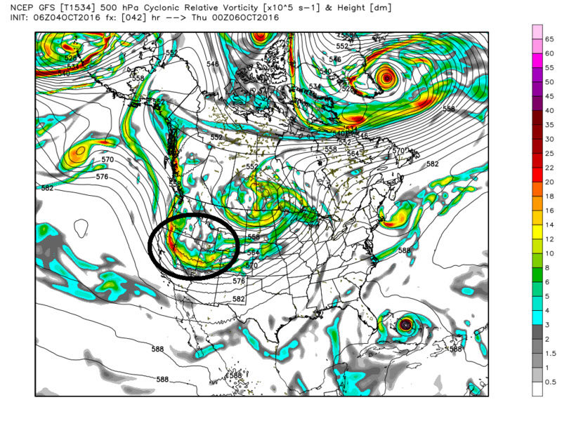

The main difference begins about 24hrs later by Friday morning. Take notice at the differences just off the west coast of Canada and the NW CONUS. Euro simply has a weak upper level low feature which leads to a series of weak LP strung out leading to an extremely progressive flow, west to east. There is nothing to drive the energy into the plains to deepen the trough as it propagates eastward. So by 00z Sunday morning the flat progressive nature of the trough takes Matthew ENE trajectory; well S and E of our area.


GFS on the other hand...as you can see has a stronger upper level feature just off the western Canadian coast leading to one consolidated LP that raises heights out ahead of it. Not a ton, but raises heights none the less so instead of one long flate western flank to the trough it allows the energy to dig a little as it propagates across the rockies into the plains. Result is a sharper trough, although still not overly impressive, but sharp/deep enough to steer Matthew in a more NNE trajectory with much more impact to our area.
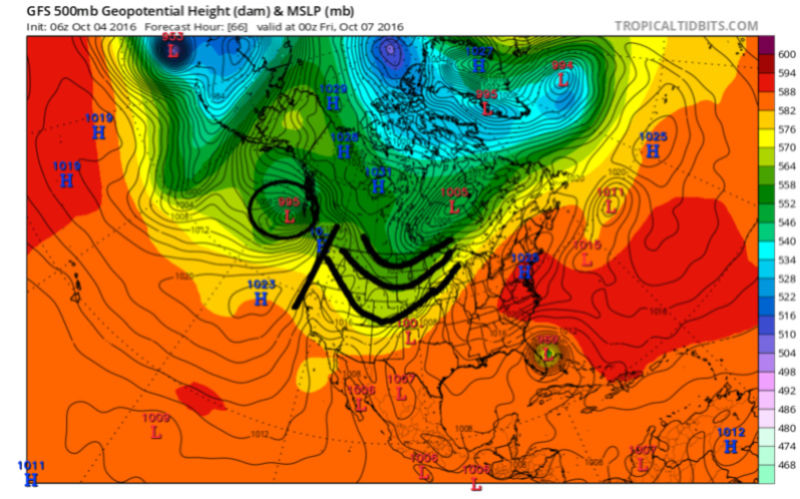
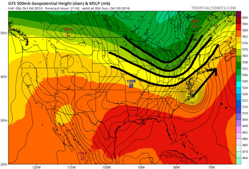
As you can see the CMC is in same camp as GFS regarding the features I just outlined in the west. The energy that I have circled in the first set of images is coming onshore today an tomorrow. It wont be long until its nailed down for sure. A blend between the CMC (strongest with the trough, and the Euro (weakest with the trough) gives you what the 6z GFS is showing which means as of now I expect impacts in the form of windy and rainy conditions. The next 24-36hrs should zero us in whether its dangerously windy and rainy vs just ehh.


The main difference begins about 24hrs later by Friday morning. Take notice at the differences just off the west coast of Canada and the NW CONUS. Euro simply has a weak upper level low feature which leads to a series of weak LP strung out leading to an extremely progressive flow, west to east. There is nothing to drive the energy into the plains to deepen the trough as it propagates eastward. So by 00z Sunday morning the flat progressive nature of the trough takes Matthew ENE trajectory; well S and E of our area.
GFS on the other hand...as you can see has a stronger upper level feature just off the western Canadian coast leading to one consolidated LP that raises heights out ahead of it. Not a ton, but raises heights none the less so instead of one long flate western flank to the trough it allows the energy to dig a little as it propagates across the rockies into the plains. Result is a sharper trough, although still not overly impressive, but sharp/deep enough to steer Matthew in a more NNE trajectory with much more impact to our area.
As you can see the CMC is in same camp as GFS regarding the features I just outlined in the west. The energy that I have circled in the first set of images is coming onshore today an tomorrow. It wont be long until its nailed down for sure. A blend between the CMC (strongest with the trough, and the Euro (weakest with the trough) gives you what the 6z GFS is showing which means as of now I expect impacts in the form of windy and rainy conditions. The next 24-36hrs should zero us in whether its dangerously windy and rainy vs just ehh.
_________________
"In weather and in life, there's no winning and losing; there's only winning and learning."
WINTER 2012/2013 TOTALS 43.65"WINTER 2017/2018 TOTALS 62.85" WINTER 2022/2023 TOTALS 4.9"
WINTER 2013/2014 TOTALS 64.85"WINTER 2018/2019 TOTALS 14.25" WINTER 2023/2024 TOTALS 13.1"
WINTER 2014/2015 TOTALS 71.20"WINTER 2019/2020 TOTALS 6.35"
WINTER 2015/2016 TOTALS 35.00"WINTER 2020/2021 TOTALS 37.75"
WINTER 2016/2017 TOTALS 42.25"WINTER 2021/2022 TOTALS 31.65"

sroc4- Admin
- Posts : 8331
Reputation : 301
Join date : 2013-01-07
Location : Wading River, LI
Re: HURRICANE MATTHEW: Phase 2--"The Turn"
![]() by jmanley32 Tue Oct 04, 2016 8:16 am
by jmanley32 Tue Oct 04, 2016 8:16 am
I also noticed the GFS 06z sped up a bit, I wonder if the trough is being under modeled on all the models, though they are there, I guess we will not know yet for at least another day. Dangerous or just ehh, lol sroc ehh, I can picture u saying that. Great analysis as always, we are waiting to see what the final out come might be. The TS force wind probabilities are slowly pushing nearly into the area, hey u gotta start somewhere.

jmanley32- Senior Enthusiast

- Posts : 20516
Reputation : 108
Join date : 2013-12-12
Age : 42
Location : Yonkers, NY
Re: HURRICANE MATTHEW: Phase 2--"The Turn"
![]() by jmanley32 Tue Oct 04, 2016 8:17 am
by jmanley32 Tue Oct 04, 2016 8:17 am
Quietace wrote:
Pretty good consensus on moderate to dangerous impacts on the area, this is just so back and forth every single day. Amazing, poor Haiti I can only imagine what it must be like at this moment.
jmanley32- Senior Enthusiast
- Posts : 20516
Reputation : 108
Join date : 2013-12-12
Age : 42
Location : Yonkers, NY
Re: HURRICANE MATTHEW: Phase 2--"The Turn"
![]() by sroc4 Tue Oct 04, 2016 8:22 am
by sroc4 Tue Oct 04, 2016 8:22 am
Larry Cosgrove is pretty convinced of the CMC/GFS/UKMET track up the coast with significant impacts likely. I have def seen him wrong before, but he has been consistent with this idea for several days now. JB on the other hand buying the east soln of the euro. with minimal impacts.
LC:
It now appears that most of the Eastern Seaboard of the USA will be affected by Major Hurricane Matthew. now battering Haiti. Matthew will exit the Windward Passage tomorrow and bend to the northwest. Over very warm waters in and about the Bahamas, the powerful storm may again attain Category 5 status. The track scenario shows a close scrape 100 miles east of the FL Atlantic Coast, then a turn inland over the Carolinas (Category 4 strength) before rolling along and to the left of the coastline with abundant wind and rain. It is entirely possible that many communities from eastern Virginia into New York and New England could see a period of damaging winds as the system starts to transition to cold-core type of character.
Much colder air will follow early next week across the Midwest and Northeast.
_________________
"In weather and in life, there's no winning and losing; there's only winning and learning."
WINTER 2012/2013 TOTALS 43.65"WINTER 2017/2018 TOTALS 62.85" WINTER 2022/2023 TOTALS 4.9"
WINTER 2013/2014 TOTALS 64.85"WINTER 2018/2019 TOTALS 14.25" WINTER 2023/2024 TOTALS 13.1"
WINTER 2014/2015 TOTALS 71.20"WINTER 2019/2020 TOTALS 6.35"
WINTER 2015/2016 TOTALS 35.00"WINTER 2020/2021 TOTALS 37.75"
WINTER 2016/2017 TOTALS 42.25"WINTER 2021/2022 TOTALS 31.65"
sroc4- Admin
- Posts : 8331
Reputation : 301
Join date : 2013-01-07
Location : Wading River, LI
Re: HURRICANE MATTHEW: Phase 2--"The Turn"
![]() by sroc4 Tue Oct 04, 2016 8:24 am
by sroc4 Tue Oct 04, 2016 8:24 am
UKIE track. Notice Nicole by day 6

_________________
"In weather and in life, there's no winning and losing; there's only winning and learning."
WINTER 2012/2013 TOTALS 43.65"WINTER 2017/2018 TOTALS 62.85" WINTER 2022/2023 TOTALS 4.9"
WINTER 2013/2014 TOTALS 64.85"WINTER 2018/2019 TOTALS 14.25" WINTER 2023/2024 TOTALS 13.1"
WINTER 2014/2015 TOTALS 71.20"WINTER 2019/2020 TOTALS 6.35"
WINTER 2015/2016 TOTALS 35.00"WINTER 2020/2021 TOTALS 37.75"
WINTER 2016/2017 TOTALS 42.25"WINTER 2021/2022 TOTALS 31.65"
sroc4- Admin
- Posts : 8331
Reputation : 301
Join date : 2013-01-07
Location : Wading River, LI
Re: HURRICANE MATTHEW: Phase 2--"The Turn"
![]() by jmanley32 Tue Oct 04, 2016 8:28 am
by jmanley32 Tue Oct 04, 2016 8:28 am
sroc4 wrote:UKIE track. Notice Nicole by day 6
Oh good grief, another one to track towards the US, storms from there likely get pushed out though. Matthew is gone by then? Wow that was fast. Euro has been speeding up though each run.
jmanley32- Senior Enthusiast
- Posts : 20516
Reputation : 108
Join date : 2013-12-12
Age : 42
Location : Yonkers, NY
Re: HURRICANE MATTHEW: Phase 2--"The Turn"
![]() by amugs Tue Oct 04, 2016 8:31 am
by amugs Tue Oct 04, 2016 8:31 am
^^ Great Post - Euro coming around to GFS idea - I can't believe on twitter and in forums that folks are saying the euro nailed this - I very much disagree


ANd I have to say I watched Channels 4 and 5 this morning and they both showed tracks up the coast nothing into NC and then gong due east - THAT in itself is....................
GEFS saying come to Pappa

NOW 12Z - OH BOY

ANd I have to say I watched Channels 4 and 5 this morning and they both showed tracks up the coast nothing into NC and then gong due east - THAT in itself is....................
GEFS saying come to Pappa
NOW 12Z - OH BOY
_________________
Mugs
AKA:King: Snow Weenie
Self Proclaimed
WINTER 2014-15 : 55.12" +.02 for 6 coatings (avg. 35")
WINTER 2015-16 Total - 29.8" (Avg 35")
WINTER 2016-17 : 39.5" so far

amugs- Advanced Forecaster - Mod

- Posts : 15093
Reputation : 213
Join date : 2013-01-07
Age : 54
Location : Hillsdale,NJ
Re: HURRICANE MATTHEW: Phase 2--"The Turn"
![]() by amugs Tue Oct 04, 2016 8:35 am
by amugs Tue Oct 04, 2016 8:35 am
sroc4 wrote:Larry Cosgrove is pretty convinced of the CMC/GFS/UKMET track up the coast with significant impacts likely. I have def seen him wrong before, but he has been consistent with this idea for several days now. JB on the other hand buying the east soln of the euro. with minimal impacts.
LC:
It now appears that most of the Eastern Seaboard of the USA will be affected by Major Hurricane Matthew. now battering Haiti. Matthew will exit the Windward Passage tomorrow and bend to the northwest. Over very warm waters in and about the Bahamas, the powerful storm may again attain Category 5 status. The track scenario shows a close scrape 100 miles east of the FL Atlantic Coast, then a turn inland over the Carolinas (Category 4 strength) before rolling along and to the left of the coastline with abundant wind and rain. It is entirely possible that many communities from eastern Virginia into New York and New England could see a period of damaging winds as the system starts to transition to cold-core type of character.
Much colder air will follow early next week across the Midwest and Northeast.
Scott,
Even JB's son is in somewhat disagreement from what he communicated with a member from teh USA board yesterday who is friends with him. JB has been euro riding all along and will go down with the ship - he keeps barking how teh Euro is right - I love JB but give it man - it has corrected 1000 miles - it EURO has been alright to good within 1-5 days but after that it has been terrible.
Bahamas are going to get whacked big time if model depiction holds - when was teh last time a Hcane of this magnitude hit them?
_________________
Mugs
AKA:King: Snow Weenie
Self Proclaimed
WINTER 2014-15 : 55.12" +.02 for 6 coatings (avg. 35")
WINTER 2015-16 Total - 29.8" (Avg 35")
WINTER 2016-17 : 39.5" so far
amugs- Advanced Forecaster - Mod
- Posts : 15093
Reputation : 213
Join date : 2013-01-07
Age : 54
Location : Hillsdale,NJ
Re: HURRICANE MATTHEW: Phase 2--"The Turn"
![]() by sroc4 Tue Oct 04, 2016 8:41 am
by sroc4 Tue Oct 04, 2016 8:41 am
amugs wrote:sroc4 wrote:Larry Cosgrove is pretty convinced of the CMC/GFS/UKMET track up the coast with significant impacts likely. I have def seen him wrong before, but he has been consistent with this idea for several days now. JB on the other hand buying the east soln of the euro. with minimal impacts.
LC:
It now appears that most of the Eastern Seaboard of the USA will be affected by Major Hurricane Matthew. now battering Haiti. Matthew will exit the Windward Passage tomorrow and bend to the northwest. Over very warm waters in and about the Bahamas, the powerful storm may again attain Category 5 status. The track scenario shows a close scrape 100 miles east of the FL Atlantic Coast, then a turn inland over the Carolinas (Category 4 strength) before rolling along and to the left of the coastline with abundant wind and rain. It is entirely possible that many communities from eastern Virginia into New York and New England could see a period of damaging winds as the system starts to transition to cold-core type of character.
Much colder air will follow early next week across the Midwest and Northeast.
Scott,
Even JB's son is in somewhat disagreement from what he communicated with a member from teh USA board yesterday who is friends with him. JB has been euro riding all along and will go down with the ship - he keeps barking how teh Euro is right - I love JB but give it man - it has corrected 1000 miles - it EURO has been alright to good within 1-5 days but after that it has been terrible.
Bahamas are going to get whacked big time if model depiction holds - when was teh last time a Hcane of this magnitude hit them?
Yeah Mugs, I know enough now to disagree with the best if I feel they are wrong. JB was one of the last to abandon the GOM idea as well.
_________________
"In weather and in life, there's no winning and losing; there's only winning and learning."
WINTER 2012/2013 TOTALS 43.65"WINTER 2017/2018 TOTALS 62.85" WINTER 2022/2023 TOTALS 4.9"
WINTER 2013/2014 TOTALS 64.85"WINTER 2018/2019 TOTALS 14.25" WINTER 2023/2024 TOTALS 13.1"
WINTER 2014/2015 TOTALS 71.20"WINTER 2019/2020 TOTALS 6.35"
WINTER 2015/2016 TOTALS 35.00"WINTER 2020/2021 TOTALS 37.75"
WINTER 2016/2017 TOTALS 42.25"WINTER 2021/2022 TOTALS 31.65"
sroc4- Admin
- Posts : 8331
Reputation : 301
Join date : 2013-01-07
Location : Wading River, LI
Re: HURRICANE MATTHEW: Phase 2--"The Turn"
![]() by Dtone Tue Oct 04, 2016 8:48 am
by Dtone Tue Oct 04, 2016 8:48 am
Frank_Wx wrote:Landfall
near Les Anglais. A Wunderground station a little east of there stopped updating after gusting to 72 mph.
Dtone- Wx Statistician Guru

- Posts : 1738
Reputation : 9
Join date : 2013-08-26
Location : Bronx, NY
Re: HURRICANE MATTHEW: Phase 2--"The Turn"
![]() by amugs Tue Oct 04, 2016 8:54 am
by amugs Tue Oct 04, 2016 8:54 am
HOLY POOPPSSSSS!!!
Level Wind Direction Wind Speed
961mb (Surface) 275° (from the W) 94 knots (108 mph)
958mb 270° (from the W) 96 knots (110 mph)
954mb 280° (from the W) 88 knots (101 mph)
947mb 280° (from the W) 122 knots (140 mph)
944mb 280° (from the W) 130 knots (150 mph)
936mb 295° (from the WNW) 115 knots (132 mph)
933mb 295° (from the WNW) 120 knots (138 mph)
930mb 290° (from the WNW) 131 knots (151 mph)
913mb 300° (from the WNW) 137 knots (158 mph)
907mb 300° (from the WNW) 134 knots (154 mph)
900mb 310° (from the NW) 140 knots (161 mph)
887mb 315° (from the NW) 132 knots (152 mph)
876mb 315° (from the NW) 141 knots (162 mph)
865mb 315° (from the NW) 120 knots (138 mph)
855mb 320° (from the NW) 120 knots (138 mph)
850mb 325° (from the NW) 115 knots (132 mph)
813mb 325° (from the NW) 91 knots (105 mph)
747mb 320° (from the NW) 96 knots (110 mph)
696mb 310° (from the NW) 82 knots (94 mph)
_________________
Mugs
AKA:King: Snow Weenie
Self Proclaimed
WINTER 2014-15 : 55.12" +.02 for 6 coatings (avg. 35")
WINTER 2015-16 Total - 29.8" (Avg 35")
WINTER 2016-17 : 39.5" so far
amugs- Advanced Forecaster - Mod
- Posts : 15093
Reputation : 213
Join date : 2013-01-07
Age : 54
Location : Hillsdale,NJ
Re: HURRICANE MATTHEW: Phase 2--"The Turn"
![]() by sroc4 Tue Oct 04, 2016 9:08 am
by sroc4 Tue Oct 04, 2016 9:08 am
It is going to be interesting to see the Google earth images of western Haitian peninsula before and after. The geography is likely changing as we speak.
_________________
"In weather and in life, there's no winning and losing; there's only winning and learning."
WINTER 2012/2013 TOTALS 43.65"WINTER 2017/2018 TOTALS 62.85" WINTER 2022/2023 TOTALS 4.9"
WINTER 2013/2014 TOTALS 64.85"WINTER 2018/2019 TOTALS 14.25" WINTER 2023/2024 TOTALS 13.1"
WINTER 2014/2015 TOTALS 71.20"WINTER 2019/2020 TOTALS 6.35"
WINTER 2015/2016 TOTALS 35.00"WINTER 2020/2021 TOTALS 37.75"
WINTER 2016/2017 TOTALS 42.25"WINTER 2021/2022 TOTALS 31.65"
sroc4- Admin
- Posts : 8331
Reputation : 301
Join date : 2013-01-07
Location : Wading River, LI
mwilli5783- Posts : 146
Reputation : 9
Join date : 2013-01-23
Age : 69
Location : hempstead n.y
Page 40 of 40 • 1 ... 21 ... 38, 39, 40
Page 40 of 40
Permissions in this forum:
You cannot reply to topics in this forum|
|
|