
 Search
Long Range Thread 9.0
Page 39 of 40 •  1 ... 21 ... 38, 39, 40
 ![]()
Frank_Wx- Godzilla Seeker

- Posts : 21305
Join date : 2013-01-05 -

Re: Long Range Thread 9.0
![]() by Frank_Wx Fri Jan 01, 2016 5:02 pm
by Frank_Wx Fri Jan 01, 2016 5:02 pm

Frank_Wx- Godzilla Seeker
- Posts : 21305
Join date : 2013-01-05 -
Re: Long Range Thread 9.0
![]() by snowlover 12345 Fri Jan 01, 2016 5:11 pm
by snowlover 12345 Fri Jan 01, 2016 5:11 pm
snowlover 12345- Posts : 29
Reputation : 0
Join date : 2016-01-01
Re: Long Range Thread 9.0
![]() by amugs Fri Jan 01, 2016 5:35 pm
by amugs Fri Jan 01, 2016 5:35 pm


_________________
Mugs
AKA:King: Snow Weenie
Self Proclaimed
WINTER 2014-15 : 55.12" +.02 for 6 coatings (avg. 35")
WINTER 2015-16 Total - 29.8" (Avg 35")
WINTER 2016-17 : 39.5" so far

amugs- Advanced Forecaster - Mod

- Posts : 15093
Reputation : 213
Join date : 2013-01-07
Age : 54
Location : Hillsdale,NJ
Re: Long Range Thread 9.0
![]() by rb924119 Fri Jan 01, 2016 5:45 pm
by rb924119 Fri Jan 01, 2016 5:45 pm
amugs wrote:JAN 9-10 going from rain to sleet to snow (DEC 2002 ?) as the LP that reforms of the coast and moves NE. Sign of things to come - it will trend colder - do not underestimate teh -EPO and Cold AIr Dam going forward.
Uhhh......

rb924119- Meteorologist

- Posts : 6890
Reputation : 194
Join date : 2013-02-06
Age : 32
Location : Greentown, Pa
Re: Long Range Thread 9.0
![]() by amugs Fri Jan 01, 2016 5:48 pm
by amugs Fri Jan 01, 2016 5:48 pm
If the aluetians vortex retrograde a tad more sw then I think the pna and epo rage to -3 SD and with rhe ao tanking we are going to be ricking, get that NAO to go Neg and bazinga baby.
Siberia and 155w to dateline thank you. LOTS of potential. Could very well see a MECS but the weenies need patience it will come.remember my discussion and I have stated ad nasueam that the models will lag the atmosphere and that things will show up once they catch on to the pattern
_________________
Mugs
AKA:King: Snow Weenie
Self Proclaimed
WINTER 2014-15 : 55.12" +.02 for 6 coatings (avg. 35")
WINTER 2015-16 Total - 29.8" (Avg 35")
WINTER 2016-17 : 39.5" so far
amugs- Advanced Forecaster - Mod
- Posts : 15093
Reputation : 213
Join date : 2013-01-07
Age : 54
Location : Hillsdale,NJ
Re: Long Range Thread 9.0
![]() by amugs Fri Jan 01, 2016 5:51 pm
by amugs Fri Jan 01, 2016 5:51 pm
That ain't the big doggy!! 18z GFS ain't going to show it and.................it shows it off the coast - does not meet the EURO or EPS or CMC or GEFS - stupid 18z!!
_________________
Mugs
AKA:King: Snow Weenie
Self Proclaimed
WINTER 2014-15 : 55.12" +.02 for 6 coatings (avg. 35")
WINTER 2015-16 Total - 29.8" (Avg 35")
WINTER 2016-17 : 39.5" so far
amugs- Advanced Forecaster - Mod
- Posts : 15093
Reputation : 213
Join date : 2013-01-07
Age : 54
Location : Hillsdale,NJ
Re: Long Range Thread 9.0
![]() by amugs Fri Jan 01, 2016 5:52 pm
by amugs Fri Jan 01, 2016 5:52 pm
amugs wrote:Rb,
That ain't the big doggy!! 18z GFS ain't going to show it and.................it shows it off the coast - does not meet the EURO or EPS or CMC or GEFS - stupid 18z!!

_________________
Mugs
AKA:King: Snow Weenie
Self Proclaimed
WINTER 2014-15 : 55.12" +.02 for 6 coatings (avg. 35")
WINTER 2015-16 Total - 29.8" (Avg 35")
WINTER 2016-17 : 39.5" so far
amugs- Advanced Forecaster - Mod
- Posts : 15093
Reputation : 213
Join date : 2013-01-07
Age : 54
Location : Hillsdale,NJ
Re: Long Range Thread 9.0
![]() by rb924119 Fri Jan 01, 2016 5:58 pm
by rb924119 Fri Jan 01, 2016 5:58 pm
amugs wrote:amugs wrote:Rb,
That ain't the big doggy!! 18z GFS ain't going to show it and.................it shows it off the coast - does not meet the EURO or EPS or CMC or GEFS - stupid 18z!!
No I know ahaha Appetizer to the main event, perhaps?
rb924119- Meteorologist
- Posts : 6890
Reputation : 194
Join date : 2013-02-06
Age : 32
Location : Greentown, Pa
frank 638- Senior Enthusiast

- Posts : 2825
Reputation : 37
Join date : 2016-01-01
Age : 40
Location : bronx ny
Re: Long Range Thread 9.0
![]() by amugs Fri Jan 01, 2016 6:05 pm
by amugs Fri Jan 01, 2016 6:05 pm
rb924119 wrote:amugs wrote:amugs wrote:Rb,
That ain't the big doggy!! 18z GFS ain't going to show it and.................it shows it off the coast - does not meet the EURO or EPS or CMC or GEFS - stupid 18z!!
No I know ahaha Appetizer to the main event, perhaps?

I think both are appys my man - I think we get the real God/Roidzilla deal between Jan 24thish and Feb 17thish - I have called a PD3 2-14-17
_________________
Mugs
AKA:King: Snow Weenie
Self Proclaimed
WINTER 2014-15 : 55.12" +.02 for 6 coatings (avg. 35")
WINTER 2015-16 Total - 29.8" (Avg 35")
WINTER 2016-17 : 39.5" so far
amugs- Advanced Forecaster - Mod
- Posts : 15093
Reputation : 213
Join date : 2013-01-07
Age : 54
Location : Hillsdale,NJ
Re: Long Range Thread 9.0
![]() by frank 638 Fri Jan 01, 2016 6:07 pm
by frank 638 Fri Jan 01, 2016 6:07 pm
Which model does everyone prefers the most euro or gfs or the nam .I know the nam is kinda weak still little confused
frank 638- Senior Enthusiast
- Posts : 2825
Reputation : 37
Join date : 2016-01-01
Age : 40
Location : bronx ny
Re: Long Range Thread 9.0
![]() by nutleyblizzard Fri Jan 01, 2016 6:35 pm
by nutleyblizzard Fri Jan 01, 2016 6:35 pm
The EURO for the most part is the most accurate when it comes to winter pattern changes and storms. I would rank the Canadian second followed by the GFS. The NAM unless 24 hours or under is for entertainment purposes only.frank 638 wrote:
Which model does everyone prefers the most euro or gfs or the nam .I know the nam is kinda weak still little confused

nutleyblizzard- Senior Enthusiast
- Posts : 1952
Reputation : 41
Join date : 2014-01-30
Age : 58
Location : Nutley, new jersey
Re: Long Range Thread 9.0
![]() by frank 638 Fri Jan 01, 2016 6:40 pm
by frank 638 Fri Jan 01, 2016 6:40 pm
frank 638- Senior Enthusiast
- Posts : 2825
Reputation : 37
Join date : 2016-01-01
Age : 40
Location : bronx ny
Re: Long Range Thread 9.0
![]() by Math23x7 Fri Jan 01, 2016 6:54 pm
by Math23x7 Fri Jan 01, 2016 6:54 pm
frank 638 wrote:That's what I thought I knew the nam is useless and the euro is better thank you
Had the EURO run from the night before "Juno" (aka the January 26-27th, 2015 snowstorm) verified, the Queens/Nassau county border region (where I am) would have gotten 30-36 inches of snow. I saw 13 inches.
Math23x7- Wx Statistician Guru

- Posts : 2379
Reputation : 68
Join date : 2013-01-08
Re: Long Range Thread 9.0
![]() by rb924119 Fri Jan 01, 2016 7:07 pm
by rb924119 Fri Jan 01, 2016 7:07 pm
frank 638 wrote:
Which model does everyone prefers the most euro or gfs or the nam .I know the nam is kinda weak still little confused
Honestly man, they ALL have their pros and cons. I'd certainly agree that generally the EURO is the best, but you can't ever take a solution verbatim (or discard one, for that matter) because it's from a particular model. Gotta keep an open mind and try to spot the differences in each, see what makes the most sense, and take it from there. I can certainly say this for myself, and I'd be willing to bet most if not all of the forecasters on here, often use blends from many different models. For example, the GFS' pattern progression, but the EURO's intensity, the NAM's temperature profile, the RGEM's precip field, etc. etc. because of what we know about particular setups, how they have played out in the past, experience and friendly discussion.
rb924119- Meteorologist
- Posts : 6890
Reputation : 194
Join date : 2013-02-06
Age : 32
Location : Greentown, Pa
Re: Long Range Thread 9.0
![]() by rb924119 Fri Jan 01, 2016 7:09 pm
by rb924119 Fri Jan 01, 2016 7:09 pm
amugs wrote:rb924119 wrote:amugs wrote:amugs wrote:Rb,
That ain't the big doggy!! 18z GFS ain't going to show it and.................it shows it off the coast - does not meet the EURO or EPS or CMC or GEFS - stupid 18z!!
No I know ahaha Appetizer to the main event, perhaps?
I think both are appys my man - I think we get the real God/Roidzilla deal between Jan 24thish and Feb 17thish - I have called a PD3 2-14-17
I would cry, not tears of anguish, but of pure joy lmao You imagine a region-wide Juno???? Another 1888....OMGGG!!!! None of us would probably ever see it, though; our hearts would probably give out the second that the first flakes fell ahahaha I sure as heck know mine would lmfao
rb924119- Meteorologist
- Posts : 6890
Reputation : 194
Join date : 2013-02-06
Age : 32
Location : Greentown, Pa
Re: Long Range Thread 9.0
![]() by mancave25 Fri Jan 01, 2016 7:10 pm
by mancave25 Fri Jan 01, 2016 7:10 pm
mancave25- Posts : 112
Reputation : 0
Join date : 2014-02-05
Re: Long Range Thread 9.0
![]() by rb924119 Fri Jan 01, 2016 7:11 pm
by rb924119 Fri Jan 01, 2016 7:11 pm

rb924119- Meteorologist
- Posts : 6890
Reputation : 194
Join date : 2013-02-06
Age : 32
Location : Greentown, Pa
Re: Long Range Thread 9.0
![]() by Frank_Wx Fri Jan 01, 2016 7:17 pm
by Frank_Wx Fri Jan 01, 2016 7:17 pm
rb924119 wrote:frank 638 wrote:
Which model does everyone prefers the most euro or gfs or the nam .I know the nam is kinda weak still little confused
Honestly man, they ALL have their pros and cons. I'd certainly agree that generally the EURO is the best, but you can't ever take a solution verbatim (or discard one, for that matter) because it's from a particular model. Gotta keep an open mind and try to spot the differences in each, see what makes the most sense, and take it from there. I can certainly say this for myself, and I'd be willing to bet most if not all of the forecasters on here, often use blends from many different models. For example, the GFS' pattern progression, but the EURO's intensity, the NAM's temperature profile, the RGEM's precip field, etc. etc. because of what we know about particular setups, how they have played out in the past, experience and friendly discussion.
Definitely agree with this.
I hate the NAM all together though. I think last year I banned the word. Anytime someone typed "NAM" I programmed the forum to turn it into "Not A Model"
_________________
_______________________________________________________________________________________________________
CLICK HERE to view NJ Strong Snowstorm Classifications

Frank_Wx- Godzilla Seeker
- Posts : 21305
Reputation : 328
Join date : 2013-01-05
Age : 31
Location : Jersey City, NJ -
Re: Long Range Thread 9.0
![]() by amugs Fri Jan 01, 2016 7:53 pm
by amugs Fri Jan 01, 2016 7:53 pm
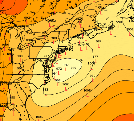
rb924119 wrote:18z GFS Ensemble for the 9th......interesting. Very interesting.
!2 hours off from my prediction I told skins a few days ago that we woudl see o our first snowfall on Jan 8th ! BUTY CYA here I gave him a range of the 8-12th.
_________________
Mugs
AKA:King: Snow Weenie
Self Proclaimed
WINTER 2014-15 : 55.12" +.02 for 6 coatings (avg. 35")
WINTER 2015-16 Total - 29.8" (Avg 35")
WINTER 2016-17 : 39.5" so far
amugs- Advanced Forecaster - Mod
- Posts : 15093
Reputation : 213
Join date : 2013-01-07
Age : 54
Location : Hillsdale,NJ
Re: Long Range Thread 9.0
![]() by nutleyblizzard Fri Jan 01, 2016 7:56 pm
by nutleyblizzard Fri Jan 01, 2016 7:56 pm
Normally the EURO will lock into a storm inside 3 days. That was a rare yet very painful bust by that model.Math23x7 wrote:frank 638 wrote:That's what I thought I knew the nam is useless and the euro is better thank you
Had the EURO run from the night before "Juno" (aka the January 26-27th, 2015 snowstorm) verified, the Queens/Nassau county border region (where I am) would have gotten 30-36 inches of snow. I saw 13 inches.
nutleyblizzard- Senior Enthusiast
- Posts : 1952
Reputation : 41
Join date : 2014-01-30
Age : 58
Location : Nutley, new jersey
Re: Long Range Thread 9.0
![]() by frank 638 Fri Jan 01, 2016 8:31 pm
by frank 638 Fri Jan 01, 2016 8:31 pm
frank 638- Senior Enthusiast
- Posts : 2825
Reputation : 37
Join date : 2016-01-01
Age : 40
Location : bronx ny
Re: Long Range Thread 9.0
![]() by amugs Fri Jan 01, 2016 8:43 pm
by amugs Fri Jan 01, 2016 8:43 pm
_________________
Mugs
AKA:King: Snow Weenie
Self Proclaimed
WINTER 2014-15 : 55.12" +.02 for 6 coatings (avg. 35")
WINTER 2015-16 Total - 29.8" (Avg 35")
WINTER 2016-17 : 39.5" so far
amugs- Advanced Forecaster - Mod
- Posts : 15093
Reputation : 213
Join date : 2013-01-07
Age : 54
Location : Hillsdale,NJ
Re: Long Range Thread 9.0
![]() by Guest Fri Jan 01, 2016 9:02 pm
by Guest Fri Jan 01, 2016 9:02 pm
Guest- Guest
Re: Long Range Thread 9.0
![]() by NjWeatherGuy Fri Jan 01, 2016 11:05 pm
by NjWeatherGuy Fri Jan 01, 2016 11:05 pm
nutleyblizzard wrote:The EURO for the most part is the most accurate when it comes to winter pattern changes and storms. I would rank the Canadian second followed by the GFS. The NAM unless 24 hours or under is for entertainment purposes only.frank 638 wrote:
Which model does everyone prefers the most euro or gfs or the nam .I know the nam is kinda weak still little confused
EURO is not always king. Following it like lemmings has led to some very painful busts. Despite what some say they have fairly similar verification rates in general.

NjWeatherGuy- Advanced Forecaster

- Posts : 4100
Reputation : 28
Join date : 2013-01-06
Location : Belle Mead, NJ
Re: Long Range Thread 9.0
![]() by Frank_Wx Fri Jan 01, 2016 11:26 pm
by Frank_Wx Fri Jan 01, 2016 11:26 pm
_________________
_______________________________________________________________________________________________________
CLICK HERE to view NJ Strong Snowstorm Classifications
Frank_Wx- Godzilla Seeker
- Posts : 21305
Reputation : 328
Join date : 2013-01-05
Age : 31
Location : Jersey City, NJ -
Page 39 of 40 • 1 ... 21 ... 38, 39, 40 ![]()
|
|
|