
 Search
Long Range Thread 9.0
Page 21 of 40 •  1 ... 12 ... 20, 21, 22 ... 30 ... 40
 ![]()
Re: Long Range Thread 9.0
![]() by Math23x7 Wed Dec 16, 2015 12:46 am
by Math23x7 Wed Dec 16, 2015 12:46 am

Math23x7- Wx Statistician Guru

- Posts : 2379
Join date : 2013-01-08
Re: Long Range Thread 9.0
![]() by Radz Wed Dec 16, 2015 8:00 am
by Radz Wed Dec 16, 2015 8:00 am
Radz- Pro Enthusiast

- Posts : 1028
Join date : 2013-01-12
Re: Long Range Thread 9.0
![]() by CPcantmeasuresnow Wed Dec 16, 2015 8:17 am
by CPcantmeasuresnow Wed Dec 16, 2015 8:17 am

CPcantmeasuresnow- Wx Statistician Guru
- Posts : 7274
Reputation : 230
Join date : 2013-01-07
Age : 103
Location : Eastern Orange County, NY
Re: Long Range Thread 9.0
![]() by sroc4 Wed Dec 16, 2015 9:02 am
by sroc4 Wed Dec 16, 2015 9:02 am
Frank_Wx wrote:algae888 wrote:frank or scott is a pattern prone to extreme warm or cold prone to extremes in general? so that if the pattern flips we end up on the other side of extremes? dec. 1989 one of the coldest on record and jan 1990 one of the warmest on record for one example.
I feel we'll head into another extreme in the 2nd half, yes. A raging El Nino undergoing rapid weakening and a very strong Stratosphere PV warming and possibly being displaced should lead to a drastic and sudden pattern change between the 3rd or 4th week of January.
I too agree Al that an extreme can def recoil towards the opposite side of the extreme. Like a rubber band snapping back if you will. The further it's stretched the harder is snaps back. However; I say that as a broad general statement, because I don't know if my backyard will reap the benefits of the snap back, or if it's going to be seen more on a global extreme and occur over months to years vs weeks to months. Will we be in a strong La Niña by this time next year? And will other SST anomalies flip as well? The PDO region is another region that is due to go neg. it's been positive, and strong at that for several years. This year it has def trended down. As Frank and other s point out we simply are going to have to be patient and see how the decline in the Niño progresses, MJO behaves, and the stratosphere responds to the predicted warming events upcoming. For now the warming events haven't occurred yet. They are merely a prediction forthcoming by the modeling. So IF they occur like modeled, we still won't know the true effects on our weather for a couple of weeks after the fact at least. So for now we simply sit and wait and marvel at the extreme we are experiencing, like it or not. For Mother Nature runs this ship. Momma does what momma does.
_________________
"In weather and in life, there's no winning and losing; there's only winning and learning."
WINTER 2012/2013 TOTALS 43.65"WINTER 2017/2018 TOTALS 62.85" WINTER 2022/2023 TOTALS 4.9"
WINTER 2013/2014 TOTALS 64.85"WINTER 2018/2019 TOTALS 14.25" WINTER 2023/2024 TOTALS 13.1"
WINTER 2014/2015 TOTALS 71.20"WINTER 2019/2020 TOTALS 6.35"
WINTER 2015/2016 TOTALS 35.00"WINTER 2020/2021 TOTALS 37.75"
WINTER 2016/2017 TOTALS 42.25"WINTER 2021/2022 TOTALS 31.65"

sroc4- Admin

- Posts : 8331
Reputation : 301
Join date : 2013-01-07
Location : Wading River, LI
Re: Long Range Thread 9.0
![]() by Dunnzoo Wed Dec 16, 2015 9:40 am
by Dunnzoo Wed Dec 16, 2015 9:40 am
Radz wrote:Geez, near 70 in spots on Christmas Eve possible ahead of a "cool" front, with 30+ guests, you bet the windows will be open!
Maybe a pool party and BBQ? My mom was going to put away her deck table and chairs, thinking we may need to keep them out for next week!
_________________
Janet
Snowfall winter of 2023-2024 17.5"
Snowfall winter of 2022-2023 6.0"
Snowfall winter of 2021-2022 17.6" 1" sleet 2/25/22
Snowfall winter of 2020-2021 51.1"
Snowfall winter of 2019-2020 8.5"
Snowfall winter of 2018-2019 25.1"
Snowfall winter of 2017-2018 51.9"
Snowfall winter of 2016-2017 45.6"
Snowfall winter of 2015-2016 29.5"
Snowfall winter of 2014-2015 50.55"
Snowfall winter of 2013-2014 66.5"

Dunnzoo- Senior Enthusiast - Mod

- Posts : 4892
Reputation : 68
Join date : 2013-01-11
Age : 62
Location : Westwood, NJ
Re: Long Range Thread 9.0
![]() by algae888 Wed Dec 16, 2015 11:10 am
by algae888 Wed Dec 16, 2015 11:10 am

algae888- Advanced Forecaster

- Posts : 5311
Reputation : 46
Join date : 2013-02-05
Age : 61
Location : mt. vernon, new york
Re: Long Range Thread 9.0
![]() by algae888 Wed Dec 16, 2015 11:14 am
by algae888 Wed Dec 16, 2015 11:14 am
algae888- Advanced Forecaster
- Posts : 5311
Reputation : 46
Join date : 2013-02-05
Age : 61
Location : mt. vernon, new york
Re: Long Range Thread 9.0
![]() by nutleyblizzard Wed Dec 16, 2015 11:38 am
by nutleyblizzard Wed Dec 16, 2015 11:38 am
Hope your right. I can't take much more of this warm weather. Its only 9 days till christmas, and I haven't seen a single snowflake.algae888 wrote:Why I would assume the MJO forecast is correct is that we are starting to see convection moving north into the northern hemisphere around the Date Line from the observations. I guess the question becomes is the mjo driving our pattern or just an enhancer. Either way I would assume changes in our pattern sometime early January.

nutleyblizzard- Senior Enthusiast

- Posts : 1952
Reputation : 41
Join date : 2014-01-30
Age : 58
Location : Nutley, new jersey
Re: Long Range Thread 9.0
![]() by CPcantmeasuresnow Wed Dec 16, 2015 11:55 am
by CPcantmeasuresnow Wed Dec 16, 2015 11:55 am
nutleyblizzard wrote:Hope your right. I can't take much more of this warm weather. Its only 9 days till christmas, and I haven't seen a single snowflake.algae888 wrote:Why I would assume the MJO forecast is correct is that we are starting to see convection moving north into the northern hemisphere around the Date Line from the observations. I guess the question becomes is the mjo driving our pattern or just an enhancer. Either way I would assume changes in our pattern sometime early January.
I posted this in another thread but it's worth a re-post because it's so ridiculous.
The warmest December ever in NYC was in 2001 when the average temperature was a ridiculously mild for December of 44.1 degrees.
To this point the average temperature this December is 52.0 in NYC.
It's beyond ridiculous.
Dtone also added to this that if the 2 week forecast is fairly accurate this December would rank as one of the top 10 warmest Novembers. And some people wonder why snow nuts are going nuts this year. Think about that, it's insane.
CPcantmeasuresnow- Wx Statistician Guru
- Posts : 7274
Reputation : 230
Join date : 2013-01-07
Age : 103
Location : Eastern Orange County, NY
Re: Long Range Thread 9.0
![]() by HectorO Wed Dec 16, 2015 12:26 pm
by HectorO Wed Dec 16, 2015 12:26 pm

HectorO- Pro Enthusiast
- Posts : 959
Reputation : 27
Join date : 2013-01-11
Re: Long Range Thread 9.0
![]() by algae888 Wed Dec 16, 2015 12:49 pm
by algae888 Wed Dec 16, 2015 12:49 pm
algae888- Advanced Forecaster
- Posts : 5311
Reputation : 46
Join date : 2013-02-05
Age : 61
Location : mt. vernon, new york
Re: Long Range Thread 9.0
![]() by amugs Wed Dec 16, 2015 1:17 pm
by amugs Wed Dec 16, 2015 1:17 pm
HectorO wrote:Records are meant to be broken. We had record lows last winter and will probably have record highs this winter. If this winter busts, then there's always other ones to look forward to. 11/12 was a a crappy winter, one of the least snowiest I've seen in this area and then it was followed by a few really nice ones. As I said on another post, every couple of winters we're due for a bust. We had a decent run.
"winters we're due for a bust", this is not a bust since it ain't over until march 1st (met winter ends but we go longer into March like last year) and I hope you aren't writing off winter like last year at this point. Recall we got smoked from mid Jan through March. Latest long range guidance is showing that the stratosphere ssw event is going on and and that another one will be hitting by new years which will help displace the PV - the AK vortex will retrograde SW of the Aleutians allowing for that Siberian Express to start its decent on the eastern seaboard, A NEG Trough builds in the Se and the heights will rise in BC Canada due to this AL low retrograding. I would not call bust at this juncture - yes is it abnormally or historically warm no doubt but to call winter a bust at this stage is not prudent IMHO. I am holding steadfast and will be 1st mate to SROC on the "SS Winter Comith". We have no snow nor cold but that will change abruptly next month.
_________________
Mugs
AKA:King: Snow Weenie
Self Proclaimed
WINTER 2014-15 : 55.12" +.02 for 6 coatings (avg. 35")
WINTER 2015-16 Total - 29.8" (Avg 35")
WINTER 2016-17 : 39.5" so far

amugs- Advanced Forecaster - Mod
- Posts : 15093
Reputation : 213
Join date : 2013-01-07
Age : 54
Location : Hillsdale,NJ
Re: Long Range Thread 9.0
![]() by CPcantmeasuresnow Wed Dec 16, 2015 1:26 pm
by CPcantmeasuresnow Wed Dec 16, 2015 1:26 pm
algae888 wrote:Both the GFS and Canadian bring a cold front through Christmas eve and while Christmas will not be white it should be cold and definitely not 70 degrees
Please define cold Al. What you mean is it will only be 15 degrees above normal on Christmas Day instead of 30?

CPcantmeasuresnow- Wx Statistician Guru
- Posts : 7274
Reputation : 230
Join date : 2013-01-07
Age : 103
Location : Eastern Orange County, NY
Re: Long Range Thread 9.0
![]() by amugs Wed Dec 16, 2015 1:32 pm
by amugs Wed Dec 16, 2015 1:32 pm
https://twitter.com/USAwx/status/677168367971794945
_________________
Mugs
AKA:King: Snow Weenie
Self Proclaimed
WINTER 2014-15 : 55.12" +.02 for 6 coatings (avg. 35")
WINTER 2015-16 Total - 29.8" (Avg 35")
WINTER 2016-17 : 39.5" so far
amugs- Advanced Forecaster - Mod
- Posts : 15093
Reputation : 213
Join date : 2013-01-07
Age : 54
Location : Hillsdale,NJ
Re: Long Range Thread 9.0
![]() by amugs Wed Dec 16, 2015 1:34 pm
by amugs Wed Dec 16, 2015 1:34 pm

Last edited by amugs on Wed Dec 16, 2015 2:53 pm; edited 1 time in total
_________________
Mugs
AKA:King: Snow Weenie
Self Proclaimed
WINTER 2014-15 : 55.12" +.02 for 6 coatings (avg. 35")
WINTER 2015-16 Total - 29.8" (Avg 35")
WINTER 2016-17 : 39.5" so far
amugs- Advanced Forecaster - Mod
- Posts : 15093
Reputation : 213
Join date : 2013-01-07
Age : 54
Location : Hillsdale,NJ
Re: Long Range Thread 9.0
![]() by algae888 Wed Dec 16, 2015 2:12 pm
by algae888 Wed Dec 16, 2015 2:12 pm
Well when I say cold CP more like normal temperatures in the low to mid forties however today euro shows an absolute torch for Christmas Eve, Christmas and the day after. It is notoriously slower than the GFS with bringing fronts through and digging shortwaves in the southwest. still 9 days out we'll see what happensCPcantmeasuresnow wrote:algae888 wrote:Both the GFS and Canadian bring a cold front through Christmas eve and while Christmas will not be white it should be cold and definitely not 70 degrees
Please define cold Al. What you mean is it will only be 15 degrees above normal on Christmas Day instead of 30?
algae888- Advanced Forecaster
- Posts : 5311
Reputation : 46
Join date : 2013-02-05
Age : 61
Location : mt. vernon, new york
Re: Long Range Thread 9.0
![]() by CPcantmeasuresnow Wed Dec 16, 2015 2:52 pm
by CPcantmeasuresnow Wed Dec 16, 2015 2:52 pm
algae888 wrote:Well when I say cold CP more like normal temperatures in the low to mid forties however today euro shows an absolute torch for Christmas Eve, Christmas and the day after. It is notoriously slower than the GFS with bringing fronts through and digging shortwaves in the southwest. still 9 days out we'll see what happensCPcantmeasuresnow wrote:algae888 wrote:Both the GFS and Canadian bring a cold front through Christmas eve and while Christmas will not be white it should be cold and definitely not 70 degrees
Please define cold Al. What you mean is it will only be 15 degrees above normal on Christmas Day instead of 30?
The average high in NYC on Christmas day is 40 the average low is 29. They have not had a day anywhere close to that yet since fall began.
CPcantmeasuresnow- Wx Statistician Guru
- Posts : 7274
Reputation : 230
Join date : 2013-01-07
Age : 103
Location : Eastern Orange County, NY
Abba701- Posts : 328
Reputation : 0
Join date : 2013-01-14
Abba701- Posts : 328
Reputation : 0
Join date : 2013-01-14
Re: Long Range Thread 9.0
![]() by Frank_Wx Wed Dec 16, 2015 5:53 pm
by Frank_Wx Wed Dec 16, 2015 5:53 pm
_________________
_______________________________________________________________________________________________________
CLICK HERE to view NJ Strong Snowstorm Classifications

Frank_Wx- Godzilla Seeker
- Posts : 21305
Reputation : 328
Join date : 2013-01-05
Age : 31
Location : Jersey City, NJ -

Re: Long Range Thread 9.0
![]() by devsman Wed Dec 16, 2015 7:13 pm
by devsman Wed Dec 16, 2015 7:13 pm

devsman- Pro Enthusiast
- Posts : 424
Reputation : 4
Join date : 2014-01-01
Age : 48
Location : merrick, ny (south shore of Long Island)
Re: Long Range Thread 9.0
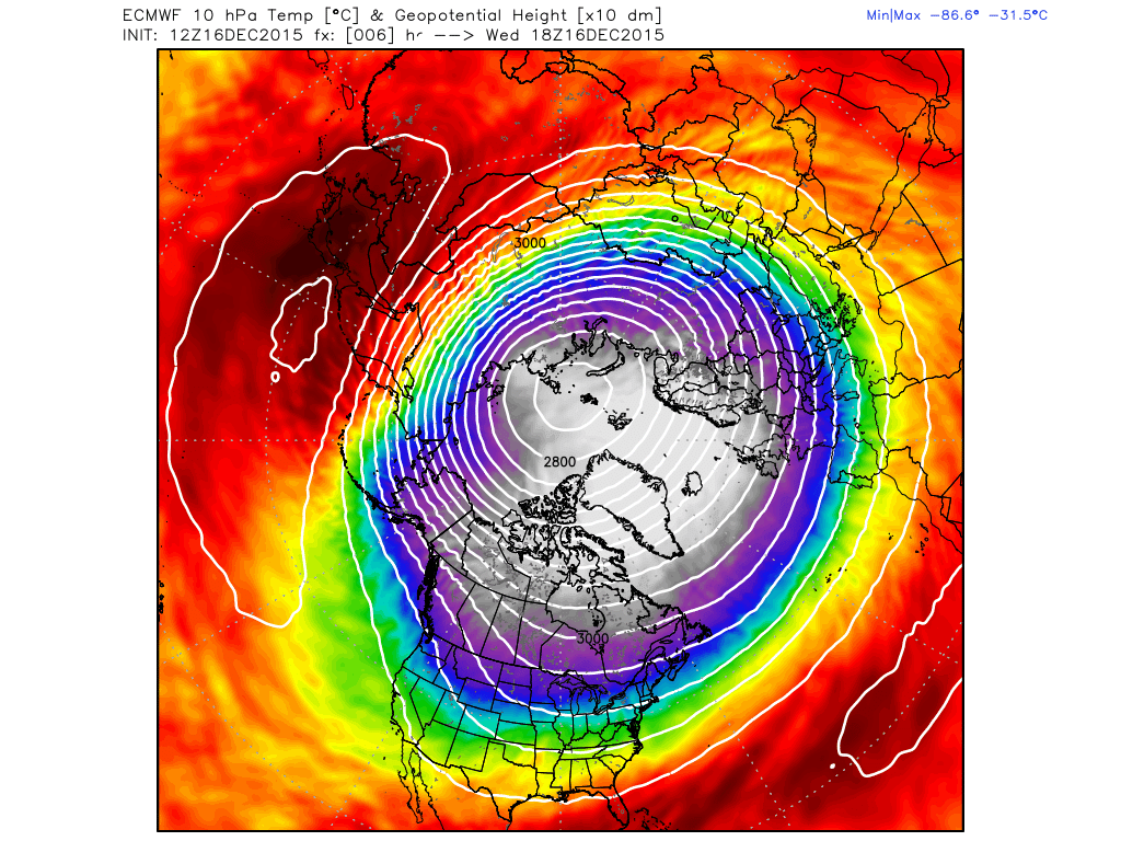
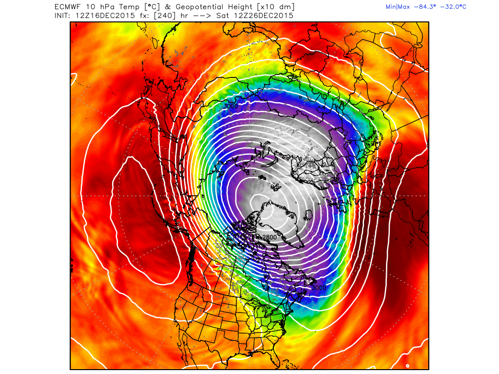
![]() by amugs Wed Dec 16, 2015 8:03 pm
by amugs Wed Dec 16, 2015 8:03 pm
today
Dec 26th
_________________
Mugs
AKA:King: Snow Weenie
Self Proclaimed
WINTER 2014-15 : 55.12" +.02 for 6 coatings (avg. 35")
WINTER 2015-16 Total - 29.8" (Avg 35")
WINTER 2016-17 : 39.5" so far
amugs- Advanced Forecaster - Mod
- Posts : 15093
Reputation : 213
Join date : 2013-01-07
Age : 54
Location : Hillsdale,NJ
Re: Long Range Thread 9.0
![]() by skinsfan1177 Wed Dec 16, 2015 8:10 pm
by skinsfan1177 Wed Dec 16, 2015 8:10 pm
This is a positiveamugs wrote:Euro saying PV dislodging
today
Dec 26th

skinsfan1177- Senior Enthusiast
- Posts : 4485
Reputation : 35
Join date : 2013-01-07
Age : 46
Location : Point Pleasant Boro
Re: Long Range Thread 9.0
![]() by Frank_Wx Wed Dec 16, 2015 8:12 pm
by Frank_Wx Wed Dec 16, 2015 8:12 pm
_________________
_______________________________________________________________________________________________________
CLICK HERE to view NJ Strong Snowstorm Classifications
Frank_Wx- Godzilla Seeker
- Posts : 21305
Reputation : 328
Join date : 2013-01-05
Age : 31
Location : Jersey City, NJ -
Re: Long Range Thread 9.0
![]() by skinsfan1177 Wed Dec 16, 2015 8:21 pm
by skinsfan1177 Wed Dec 16, 2015 8:21 pm
Frank_Wx wrote:You can see its getting squeezed from both sides. That means we're heading into a wave 2 event. Think of it as squeezing a bottle of toothpaste. Vorticity within the center gets elongated and PV center gets stretched out. That said, it's still over the North Pole. Still more work to be done.
So Frank how do we get the PV to move south and give us the cold that we need and in that Dec.26 picture it still up in Canada.
skinsfan1177- Senior Enthusiast
- Posts : 4485
Reputation : 35
Join date : 2013-01-07
Age : 46
Location : Point Pleasant Boro
Re: Long Range Thread 9.0
![]() by Frank_Wx Wed Dec 16, 2015 8:50 pm
by Frank_Wx Wed Dec 16, 2015 8:50 pm
.skinsfan1177 wrote:Frank_Wx wrote:You can see its getting squeezed from both sides. That means we're heading into a wave 2 event. Think of it as squeezing a bottle of toothpaste. Vorticity within the center gets elongated and PV center gets stretched out. That said, it's still over the North Pole. Still more work to be done.
So Frank how do we get the PV to move south and give us the cold that we need and in that Dec.26 picture it still up in Canada.
The sudden Stratospheric Warming can not be confined to just 1 or 10 hPa (upper Stratosphere). It needs to downwell into the mid and lower levels. This would displace the PV out of the Pole and into the lower latitudes of North America
_________________
_______________________________________________________________________________________________________
CLICK HERE to view NJ Strong Snowstorm Classifications
Frank_Wx- Godzilla Seeker
- Posts : 21305
Reputation : 328
Join date : 2013-01-05
Age : 31
Location : Jersey City, NJ -
Re: Long Range Thread 9.0
![]() by chief7 Wed Dec 16, 2015 10:16 pm
by chief7 Wed Dec 16, 2015 10:16 pm
chief7- Posts : 132
Reputation : 0
Join date : 2013-11-10
Location : Langhorne pa
Page 21 of 40 • 1 ... 12 ... 20, 21, 22 ... 30 ... 40 ![]()
|
|
|