
 Search
Long Range Thread 9.0
Page 38 of 40 •  1 ... 20 ... 37, 38, 39, 40
 ![]()
Re: Long Range Thread 9.0
![]() by chief7 Thu Dec 31, 2015 8:16 pm
by chief7 Thu Dec 31, 2015 8:16 pm
chief7- Posts : 132
Join date : 2013-11-10
Re: Long Range Thread 9.0
![]() by NjWeatherGuy Fri Jan 01, 2016 3:01 am
by NjWeatherGuy Fri Jan 01, 2016 3:01 am
http://mag.ncep.noaa.gov/Image.php?fhr=276&image=data%2Fgfs%2F00%2Fgfs_namer_276_850_temp_mslp_precip.gif&model=gfs&area=namer¶m=850_temp_mslp_precip&group=Model+Guidance&preselected_formatted_cycle_date=20160101+00+UTC&imageSize=M&ps=model
NjWeatherGuy- Advanced Forecaster

- Posts : 4100
Join date : 2013-01-06
Re: Long Range Thread 9.0
![]() by Snow88 Fri Jan 01, 2016 9:36 am
by Snow88 Fri Jan 01, 2016 9:36 am

Snow88- Senior Enthusiast

- Posts : 2193
Reputation : 4
Join date : 2013-01-09
Age : 35
Location : Brooklyn, NY
Re: Long Range Thread 9.0
![]() by CPcantmeasuresnow Fri Jan 01, 2016 9:37 am
by CPcantmeasuresnow Fri Jan 01, 2016 9:37 am
NjWeatherGuy wrote:Holy mother of 0z GFS, Happy New Year 2016!
http://mag.ncep.noaa.gov/Image.php?fhr=276&image=data%2Fgfs%2F00%2Fgfs_namer_276_850_temp_mslp_precip.gif&model=gfs&area=namer¶m=850_temp_mslp_precip&group=Model+Guidance&preselected_formatted_cycle_date=20160101+00+UTC&imageSize=M&ps=model
12 days away.
What a beautiful setup. A HV special, but most share in the fun.

CPcantmeasuresnow- Wx Statistician Guru

- Posts : 7274
Reputation : 230
Join date : 2013-01-07
Age : 103
Location : Eastern Orange County, NY
Re: Long Range Thread 9.0
![]() by skinsfan1177 Fri Jan 01, 2016 10:01 am
by skinsfan1177 Fri Jan 01, 2016 10:01 am
CPcantmeasuresnow wrote:NjWeatherGuy wrote:Holy mother of 0z GFS, Happy New Year 2016!
http://mag.ncep.noaa.gov/Image.php?fhr=276&image=data%2Fgfs%2F00%2Fgfs_namer_276_850_temp_mslp_precip.gif&model=gfs&area=namer¶m=850_temp_mslp_precip&group=Model+Guidance&preselected_formatted_cycle_date=20160101+00+UTC&imageSize=M&ps=model
12 days away.
What a beautiful setup. A HV special, but most share in the fun.
Hoping for coastal blizzard I think this year will deliver and once again I will be over seasonal avg. South and east my friend

skinsfan1177- Senior Enthusiast
- Posts : 4485
Reputation : 35
Join date : 2013-01-07
Age : 46
Location : Point Pleasant Boro
Re: Long Range Thread 9.0
![]() by Frank_Wx Fri Jan 01, 2016 10:04 am
by Frank_Wx Fri Jan 01, 2016 10:04 am
00z EPS:

6z GEFS::
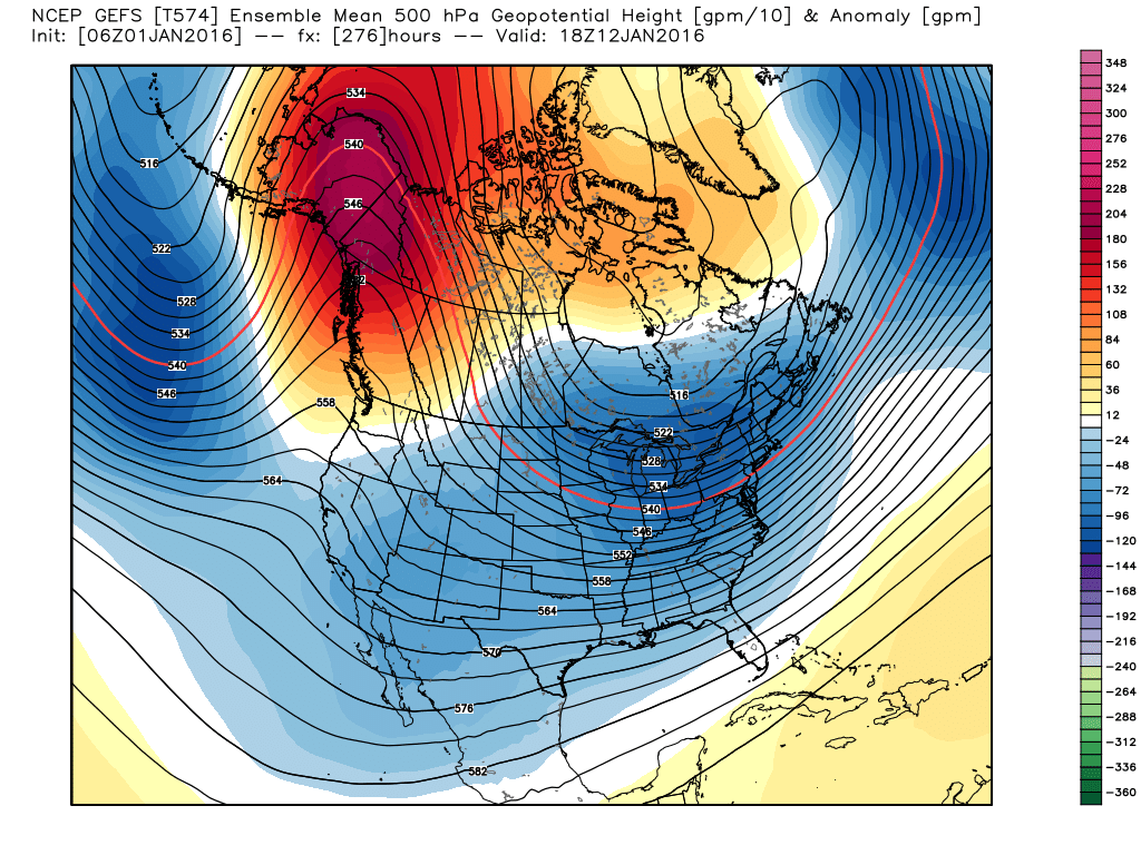
The bias' of each model come into play with both graphics. Notcce the EPS is much more amplified with the mid-level troughs compared to the GEFS. On the other end, the GEFS are looking progressive / elongated with the troughs. Specifically, the GEFS show a trough axis over the Great Lakes while the EPS dig it into the southeast. Lastly, placement of the PNA/EPO ridge differs with both ensemble suites. The EPS has the core of the positive heights over western Canada with a slight SW to NE orientation. The GEFS has the ridge over Alaska (further N&W) with more of a N-S orientation.
IMO, with a ridge to that degree of amplification, it should yield a trough similar to what the EPS shows. I think the GEFS bias is more at play here since it's trying to keep the axis of the trough further north and keep the flow across the U.S. progressive, hence the lower heights entering the west.
There's some blocking to work with as well. Higher heights shown near the Davis Strait should also lead to an eastern US trough axis similar to where the EPS has it. A deep trough over the NW Atlantic could act as a roadblock for energy to escape out to sea. Timing plays a critical role with how the upper level vort energies interact. Plenty of time to watch this one. Just gotta see where the trends take us.
_________________
_______________________________________________________________________________________________________
CLICK HERE to view NJ Strong Snowstorm Classifications

Frank_Wx- Godzilla Seeker

- Posts : 21305
Reputation : 328
Join date : 2013-01-05
Age : 31
Location : Jersey City, NJ -

Re: Long Range Thread 9.0
![]() by hyde345 Fri Jan 01, 2016 12:09 pm
by hyde345 Fri Jan 01, 2016 12:09 pm

hyde345- Pro Enthusiast

- Posts : 1082
Reputation : 48
Join date : 2013-01-08
Location : Hyde Park, NY
Re: Long Range Thread 9.0
![]() by docstox12 Fri Jan 01, 2016 12:11 pm
by docstox12 Fri Jan 01, 2016 12:11 pm
skinsfan1177 wrote:CPcantmeasuresnow wrote:NjWeatherGuy wrote:Holy mother of 0z GFS, Happy New Year 2016!
http://mag.ncep.noaa.gov/Image.php?fhr=276&image=data%2Fgfs%2F00%2Fgfs_namer_276_850_temp_mslp_precip.gif&model=gfs&area=namer¶m=850_temp_mslp_precip&group=Model+Guidance&preselected_formatted_cycle_date=20160101+00+UTC&imageSize=M&ps=model
12 days away.
What a beautiful setup. A HV special, but most share in the fun.
Hoping for coastal blizzard I think this year will deliver and once again I will be over seasonal avg. South and east my friend
LOL, don't even joke about that Skins.If you get 17 inches and the "extremely sharp" cutoff is the Bergen County-Orange County line and we get 1.75 inch in the HV, there may be a suicide watch issued for our good buddy CP,LOL!

docstox12- Wx Statistician Guru
- Posts : 8507
Reputation : 222
Join date : 2013-01-07
Age : 73
Location : Monroe NY
Re: Long Range Thread 9.0
![]() by Frank_Wx Fri Jan 01, 2016 12:23 pm
by Frank_Wx Fri Jan 01, 2016 12:23 pm
hyde345 wrote:Just looked at the 12Z GFS. It is really struggling in the long range. What the hell is it doing after 252 hrs?
The GFS is struggling with the pattern. The signals are there which is all that matters. Lean on the EURO and CMC. I'll post their maps when they come out.
_________________
_______________________________________________________________________________________________________
CLICK HERE to view NJ Strong Snowstorm Classifications
Frank_Wx- Godzilla Seeker
- Posts : 21305
Reputation : 328
Join date : 2013-01-05
Age : 31
Location : Jersey City, NJ -
Re: Long Range Thread 9.0
![]() by Frank_Wx Fri Jan 01, 2016 12:34 pm
by Frank_Wx Fri Jan 01, 2016 12:34 pm
_________________
_______________________________________________________________________________________________________
CLICK HERE to view NJ Strong Snowstorm Classifications
Frank_Wx- Godzilla Seeker
- Posts : 21305
Reputation : 328
Join date : 2013-01-05
Age : 31
Location : Jersey City, NJ -
Re: Long Range Thread 9.0
![]() by CPcantmeasuresnow Fri Jan 01, 2016 1:33 pm
by CPcantmeasuresnow Fri Jan 01, 2016 1:33 pm
docstox12 wrote:skinsfan1177 wrote:CPcantmeasuresnow wrote:NjWeatherGuy wrote:Holy mother of 0z GFS, Happy New Year 2016!
http://mag.ncep.noaa.gov/Image.php?fhr=276&image=data%2Fgfs%2F00%2Fgfs_namer_276_850_temp_mslp_precip.gif&model=gfs&area=namer¶m=850_temp_mslp_precip&group=Model+Guidance&preselected_formatted_cycle_date=20160101+00+UTC&imageSize=M&ps=model
12 days away.
What a beautiful setup. A HV special, but most share in the fun.
Hoping for coastal blizzard I think this year will deliver and once again I will be over seasonal avg. South and east my friend
LOL, don't even joke about that Skins.If you get 17 inches and the "extremely sharp" cutoff is the Bergen County-Orange County line and we get 1.75 inch in the HV, there may be a suicide watch issued for our good buddy CP,LOL!
You know me Doc, I'm almost there now after this December from Hell.
You coined it Hellnino, thank God it's finally loosening it's ugly grip.
CPcantmeasuresnow- Wx Statistician Guru
- Posts : 7274
Reputation : 230
Join date : 2013-01-07
Age : 103
Location : Eastern Orange County, NY
Re: Long Range Thread 9.0
![]() by Abba701 Fri Jan 01, 2016 1:35 pm
by Abba701 Fri Jan 01, 2016 1:35 pm
February? Still cold?
Abba701- Posts : 328
Reputation : 0
Join date : 2013-01-14
Re: Long Range Thread 9.0
![]() by Snowfall Fri Jan 01, 2016 1:50 pm
by Snowfall Fri Jan 01, 2016 1:50 pm
Snowfall- Posts : 59
Reputation : 0
Join date : 2015-12-31
Re: Long Range Thread 9.0
![]() by Frank_Wx Fri Jan 01, 2016 2:15 pm
by Frank_Wx Fri Jan 01, 2016 2:15 pm
Snowfall wrote:No major storms until the half point of January maybe a snow shower but nothing more. I do see at least two 12 plus storms this season and that hot Atlantic water we will be thanking
We'll see, the 10th-12th period needs to be watched. The EURO literally has off the charts type of blocking

_________________
_______________________________________________________________________________________________________
CLICK HERE to view NJ Strong Snowstorm Classifications
Frank_Wx- Godzilla Seeker
- Posts : 21305
Reputation : 328
Join date : 2013-01-05
Age : 31
Location : Jersey City, NJ -
Re: Long Range Thread 9.0
![]() by Frank_Wx Fri Jan 01, 2016 2:25 pm
by Frank_Wx Fri Jan 01, 2016 2:25 pm
_________________
_______________________________________________________________________________________________________
CLICK HERE to view NJ Strong Snowstorm Classifications
Frank_Wx- Godzilla Seeker
- Posts : 21305
Reputation : 328
Join date : 2013-01-05
Age : 31
Location : Jersey City, NJ -
Re: Long Range Thread 9.0
![]() by billg315 Fri Jan 01, 2016 2:32 pm
by billg315 Fri Jan 01, 2016 2:32 pm

billg315- Advanced Forecaster - Mod

- Posts : 4469
Reputation : 185
Join date : 2015-01-24
Age : 50
Location : Flemington, NJ
Re: Long Range Thread 9.0
![]() by RJB8525 Fri Jan 01, 2016 2:42 pm
by RJB8525 Fri Jan 01, 2016 2:42 pm
Snowfall wrote:No major storms until the half point of January maybe a snow shower but nothing more. I do see at least two 12 plus storms this season and that hot Atlantic water we will be thanking
bold statement lol
3 words
ya gotta believe!

RJB8525- Senior Enthusiast
- Posts : 1994
Reputation : 28
Join date : 2013-02-06
Age : 38
Location : Hackettstown, NJ
Re: Long Range Thread 9.0
![]() by Snowfall Fri Jan 01, 2016 3:33 pm
by Snowfall Fri Jan 01, 2016 3:33 pm
Snowfall- Posts : 59
Reputation : 0
Join date : 2015-12-31
Re: Long Range Thread 9.0
![]() by Frank_Wx Fri Jan 01, 2016 3:36 pm
by Frank_Wx Fri Jan 01, 2016 3:36 pm
_________________
_______________________________________________________________________________________________________
CLICK HERE to view NJ Strong Snowstorm Classifications
Frank_Wx- Godzilla Seeker
- Posts : 21305
Reputation : 328
Join date : 2013-01-05
Age : 31
Location : Jersey City, NJ -
Re: Long Range Thread 9.0
![]() by nutleyblizzard Fri Jan 01, 2016 3:48 pm
by nutleyblizzard Fri Jan 01, 2016 3:48 pm
Welcome to the board Snowfall. I agree with you the likelihood of multiple major snowstorm events occurring. What the latest EURO is showing is purely spellbinding. When you have ample cold air soon to be available with blocking and the gulf open for business, that makes for explosive potential. I firmly believe its not a matter of if anymore, its when.Snowfall wrote:No major storms until the half point of January maybe a snow shower but nothing more. I do see at least two 12 plus storms this season and that hot Atlantic water we will be thanking

nutleyblizzard- Senior Enthusiast
- Posts : 1952
Reputation : 41
Join date : 2014-01-30
Age : 58
Location : Nutley, new jersey
Re: Long Range Thread 9.0
![]() by rb924119 Fri Jan 01, 2016 3:58 pm
by rb924119 Fri Jan 01, 2016 3:58 pm
rb924119- Meteorologist

- Posts : 6890
Reputation : 194
Join date : 2013-02-06
Age : 32
Location : Greentown, Pa


algae888- Advanced Forecaster
- Posts : 5311
Reputation : 46
Join date : 2013-02-05
Age : 61
Location : mt. vernon, new york
Re: Long Range Thread 9.0
![]() by nutleyblizzard Fri Jan 01, 2016 4:02 pm
by nutleyblizzard Fri Jan 01, 2016 4:02 pm
That 500mb map is weather porn Frank. Let's see if it delivers the goods. I think it will.Frank_Wx wrote:Check out @nj_strong_wx's Tweet: https://twitter.com/nj_strong_wx/status/683023561808830465?s=09
nutleyblizzard- Senior Enthusiast
- Posts : 1952
Reputation : 41
Join date : 2014-01-30
Age : 58
Location : Nutley, new jersey
Re: Long Range Thread 9.0
![]() by algae888 Fri Jan 01, 2016 4:22 pm
by algae888 Fri Jan 01, 2016 4:22 pm

algae888- Advanced Forecaster
- Posts : 5311
Reputation : 46
Join date : 2013-02-05
Age : 61
Location : mt. vernon, new york
Re: Long Range Thread 9.0
![]() by algae888 Fri Jan 01, 2016 4:29 pm
by algae888 Fri Jan 01, 2016 4:29 pm
algae888- Advanced Forecaster
- Posts : 5311
Reputation : 46
Join date : 2013-02-05
Age : 61
Location : mt. vernon, new york
Re: Long Range Thread 9.0
![]() by Frank_Wx Fri Jan 01, 2016 4:55 pm
by Frank_Wx Fri Jan 01, 2016 4:55 pm
_________________
_______________________________________________________________________________________________________
CLICK HERE to view NJ Strong Snowstorm Classifications
Frank_Wx- Godzilla Seeker
- Posts : 21305
Reputation : 328
Join date : 2013-01-05
Age : 31
Location : Jersey City, NJ -
Re: Long Range Thread 9.0
![]() by Frank_Wx Fri Jan 01, 2016 5:02 pm
by Frank_Wx Fri Jan 01, 2016 5:02 pm

_________________
_______________________________________________________________________________________________________
CLICK HERE to view NJ Strong Snowstorm Classifications
Frank_Wx- Godzilla Seeker
- Posts : 21305
Reputation : 328
Join date : 2013-01-05
Age : 31
Location : Jersey City, NJ -
Page 38 of 40 • 1 ... 20 ... 37, 38, 39, 40 ![]()
|
|
|