Long Range Thread 9.0
+35
snowlover 12345
Snowfall
hyde345
Mathgod55
Dtone
weatherwatchermom
WOLVES1
elkiehound
devsman
Radz
Abba701
dkodgis
Quietace
Vinnydula
CPcantmeasuresnow
billg315
snow247
Math23x7
RJB8525
docstox12
jmanley32
HectorO
31MBP
NjWeatherGuy
rb924119
skinsfan1177
nutleyblizzard
Snow88
chief7
sroc4
aiannone
amugs
Frank_Wx
algae888
Dunnzoo
39 posters
Page 4 of 40
Page 4 of 40 •  1, 2, 3, 4, 5 ... 22 ... 40
 Re: Long Range Thread 9.0
Frank_Wx wrote:sroc4 wrote:Frank_Wx wrote:Snow88 wrote:JB also thinks that the models are too warm for the start of December and should cool off as we get closer .6z GFS still shows a big storm near Dec 5. Warm this run but there is still the storm signal. It has been showing up for several runs now.
I don't see where he says that. His Saturday summary touches on the nation wide cold blast for next week, but doesn't mention December.
If you dont have a subscription you prob cant open it. Posted 8:52 this am
http://www.weatherbell.com/premium/joe-bastardi/euro-operational-flip
Thanks I'm subscribed just never look at the blog section of WB. He's looking at the EURO operational and why it made a flip. Operational models in the long range always flip, especially this time of year. It's nothing new. The point about the Typhoon recurve is valid. We'll just have to monitor closely exactly where the Canadian ridge sets up.
After he shows the operrational he shows the EPS. Basically the same maps I showed above and says the same thing I did
sroc4- Admin

- Posts : 8331
Join date : 2013-01-07
 Re: Long Range Thread 9.0
The GFS 7 to 10 days ensemble mean has a very nice look to it with the ridge all the way up into Alaska almost connecting to the Siberian Ridge and a nice trough in eastern Canada into the eastern US. The Canadian is similar the euro is not as amplified. If the GFS is correct it wouldn't take much for one of the short waves to dig and form a low somewhere along the East Coast. interesting times very late month into early December definitely looks cold on all the models. we'll see where the trends go in the coming day.
algae888- Advanced Forecaster

- Posts : 5311
Join date : 2013-02-05
 Re: Long Range Thread 9.0
JB in his latest video states that the east should watch out near December 1 for a big east coast storm with the typhoon pumping up the western ridge and a trough in the east allowing cold air into the east. Should be interesting to see what happens.

Snow88- Senior Enthusiast

- Posts : 2193
Reputation : 4
Join date : 2013-01-09
Age : 35
Location : Brooklyn, NY
 Re: Long Range Thread 9.0
No talk about the big coastal storm on the 18z GFS? 

Snow88- Senior Enthusiast

- Posts : 2193
Reputation : 4
Join date : 2013-01-09
Age : 35
Location : Brooklyn, NY
 Re: Long Range Thread 9.0
Snow88 wrote:No talk about the big coastal storm on the 18z GFS?
It's like 948 hours away lol

snow247- Pro Enthusiast

- Posts : 2417
Reputation : 0
Join date : 2014-08-27
Location : Mount Ivy, NY - Elevation 545'
 Re: Long Range Thread 9.0
[quote="Snow88"]No talk about the big coastal storm on the 18z GFS?  [/quore
Tiny put it in banter this far out
Tiny put it in banter this far out
_________________
Mugs
AKA:King: Snow Weenie
Self Proclaimed
WINTER 2014-15 : 55.12" +.02 for 6 coatings (avg. 35")
WINTER 2015-16 Total - 29.8" (Avg 35")
WINTER 2016-17 : 39.5" so far

amugs- Advanced Forecaster - Mod

- Posts : 15093
Reputation : 213
Join date : 2013-01-07
Age : 54
Location : Hillsdale,NJ
 Re: Long Range Thread 9.0
the gfs 8-10 ens mean(on the right) went from this...

to this in 12 hours.lol


to this in 12 hours.lol


algae888- Advanced Forecaster

- Posts : 5311
Reputation : 46
Join date : 2013-02-05
Age : 61
Location : mt. vernon, new york
 Re: Long Range Thread 9.0
If you get a chance Al watch JBs video from this morning.
_________________
"In weather and in life, there's no winning and losing; there's only winning and learning."
WINTER 2012/2013 TOTALS 43.65"WINTER 2017/2018 TOTALS 62.85" WINTER 2022/2023 TOTALS 4.9"
WINTER 2013/2014 TOTALS 64.85"WINTER 2018/2019 TOTALS 14.25" WINTER 2023/2024 TOTALS 13.1"
WINTER 2014/2015 TOTALS 71.20"WINTER 2019/2020 TOTALS 6.35"
WINTER 2015/2016 TOTALS 35.00"WINTER 2020/2021 TOTALS 37.75"
WINTER 2016/2017 TOTALS 42.25"WINTER 2021/2022 TOTALS 31.65"

sroc4- Admin

- Posts : 8331
Reputation : 301
Join date : 2013-01-07
Location : Wading River, LI
 Re: Long Range Thread 9.0
Nino:
The slowing of the trades is starting to take a more "fragmented" look. And the forecasted slowing of the trades is far less impressive than what we saw earlier in October and in September. That with the SOI surging to positive values makes me think that peak is extremely close, or has already been attained. remember the indicies lag with these values and I believe that we peaked last week due to this lag as was explained to me by a NWS Met and Pro Met whom taught and have been trying to get to join our board here. Could be wrong but if it did not peak then it will REAL SOON!!
SOI values
https://www.longpaddock.qld.gov.au/seasonalclimateoutlook/southernoscillationindex/30daysoivalues/
17 Nov 2015 1013.19 1008.50 11.50 -8.49 -15.50
18 Nov 2015 1013.04 1009.70 2.90 -8.06 -15.11
19 Nov 2015 1013.04 1010.30 -0.80 -7.75 -14.88
20 Nov 2015 1011.99 1009.95 -5.30 -7.71 -14.82
21 Nov 2015 1011.97 1008.95 0.80 -7.50 -14.78
22 Nov 2015 1013.38 1008.90 10.10 -6.73 -14.59
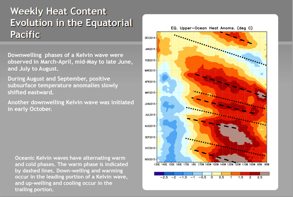
1.2 SEE YAAAAAA

OH BOY AND THERE GOES THREE!!

3.4 following in succession:
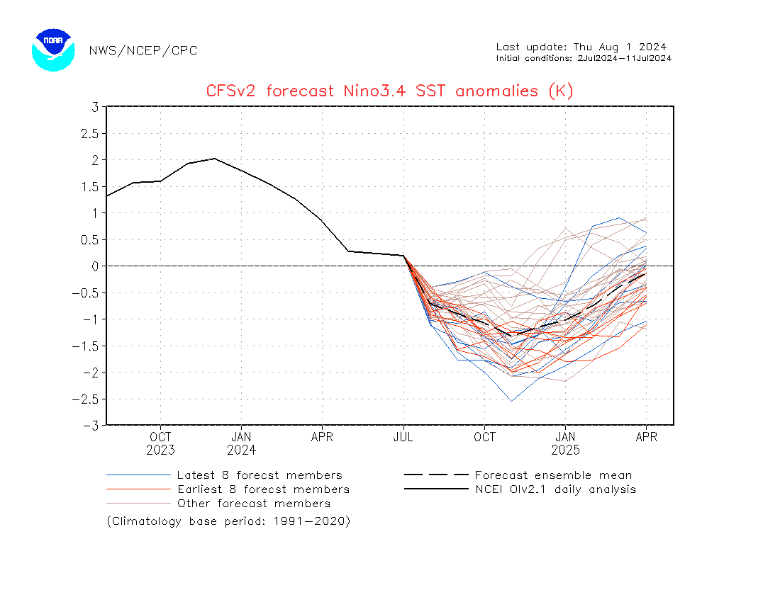
4 saying wait for me....................

If this is correct then we see like we have been harping on J-M to be a good to great winter with other factors coming into play like EPO, PNA, AO AND NAO
The slowing of the trades is starting to take a more "fragmented" look. And the forecasted slowing of the trades is far less impressive than what we saw earlier in October and in September. That with the SOI surging to positive values makes me think that peak is extremely close, or has already been attained. remember the indicies lag with these values and I believe that we peaked last week due to this lag as was explained to me by a NWS Met and Pro Met whom taught and have been trying to get to join our board here. Could be wrong but if it did not peak then it will REAL SOON!!
SOI values
https://www.longpaddock.qld.gov.au/seasonalclimateoutlook/southernoscillationindex/30daysoivalues/
17 Nov 2015 1013.19 1008.50 11.50 -8.49 -15.50
18 Nov 2015 1013.04 1009.70 2.90 -8.06 -15.11
19 Nov 2015 1013.04 1010.30 -0.80 -7.75 -14.88
20 Nov 2015 1011.99 1009.95 -5.30 -7.71 -14.82
21 Nov 2015 1011.97 1008.95 0.80 -7.50 -14.78
22 Nov 2015 1013.38 1008.90 10.10 -6.73 -14.59

1.2 SEE YAAAAAA

OH BOY AND THERE GOES THREE!!

3.4 following in succession:

4 saying wait for me....................

If this is correct then we see like we have been harping on J-M to be a good to great winter with other factors coming into play like EPO, PNA, AO AND NAO
_________________
Mugs
AKA:King: Snow Weenie
Self Proclaimed
WINTER 2014-15 : 55.12" +.02 for 6 coatings (avg. 35")
WINTER 2015-16 Total - 29.8" (Avg 35")
WINTER 2016-17 : 39.5" so far

amugs- Advanced Forecaster - Mod

- Posts : 15093
Reputation : 213
Join date : 2013-01-07
Age : 54
Location : Hillsdale,NJ
 Re: Long Range Thread 9.0
maybe our first legitimate chance at the white gold per euro...

the cmc and gfs also have this storm but cut it to our west before developing a coastal. interesting times ahead!

the cmc and gfs also have this storm but cut it to our west before developing a coastal. interesting times ahead!

algae888- Advanced Forecaster

- Posts : 5311
Reputation : 46
Join date : 2013-02-05
Age : 61
Location : mt. vernon, new york
 Re: Long Range Thread 9.0
gfs ensembles have a beautiful ridge in west in response to pna going +. epo should be neg at that time also. our two friends from the last two winters are paying us a visit...


algae888- Advanced Forecaster

- Posts : 5311
Reputation : 46
Join date : 2013-02-05
Age : 61
Location : mt. vernon, new york
 Re: Long Range Thread 9.0

not a bad look. with the +pna and ridge out west it will not take much to produce a nice storm. it will be all about timing and placement and will there be enough cold air.

algae888- Advanced Forecaster

- Posts : 5311
Reputation : 46
Join date : 2013-02-05
Age : 61
Location : mt. vernon, new york
 Re: Long Range Thread 9.0
Can't sleep Al? Yep take a look in wx banter for the snow map, if we took it verbatim......

jmanley32- Senior Enthusiast

- Posts : 20517
Reputation : 108
Join date : 2013-12-12
Age : 42
Location : Yonkers, NY
 Re: Long Range Thread 9.0
There is an update to the December 1st storm in today's Mo Mo edition, pinned to the top of the forum.
_________________
_______________________________________________________________________________________________________
CLICK HERE to view NJ Strong Snowstorm Classifications
 Re: Long Range Thread 9.0
Northeast
Found this on The Weather Channel web-site. I know most of us are not fans, but pretty interesting none-the-less. Seems like a +NAO is key for us during El-Nino.
Season Snowfall (inches)
El Niño Strong El Niño Strong El Niño and +NAO Strong El Niño and -NAO La Niña Neutral 1950-2015 Avg.
Boston 40.9 31.5 22.9 44.4 43.4 50.2 44.8
Buffalo, NY 93.1 86 68.9 111.5 95 97.3 95.1
Burlington, VT 82.2 94.1 88 103.3 86.6 78.8 82.4
Caribou, ME 111.8 121.3 120.1 123 118.7 116.5 115.5
New York City 24.9 20.3 11.8 33.1 23.6 30 26.3
Philadelphia 24.4 21.6 12.9 34.6 19.5 24.1 22.8
Pittsburgh 41.5 33.1 26.9 42.5 43.9 47.5 44.2
Syracuse, NY 114.1 108.4 94 130 117.4 122.1 117.8
Washington, DC 19.1 19.3 9.3 34.4 12.4 17.2 16.4
I highlighted the +NAO with el nino, and -NAO with el nino for comparison. Huge differences especially as you move south and to the coast.
Last edited by syosnow94 on Mon Nov 23, 2015 2:37 pm; edited 1 time in total
Guest- Guest
 Re: Long Range Thread 9.0
12z GFS December 1st storm

12z EURO

As stated in my blog from this morning, I do not like the look of the upper pattern to promote wintry weather for our area. This still needs to be watched though.

12z EURO

As stated in my blog from this morning, I do not like the look of the upper pattern to promote wintry weather for our area. This still needs to be watched though.
_________________
_______________________________________________________________________________________________________
CLICK HERE to view NJ Strong Snowstorm Classifications
 Re: Long Range Thread 9.0
A -EPO and +PNA will help this be coastal but a fast PAC flow as depicted is not going to help us. It will dampen the +PNA. BUT I like and I think we can all agree that getting a coastal is great sign at this stage. The other players will come into the arena such as the -AO and - NAO. Need a strong -EPO or -AO along with cooperation from the NAO to get something this time of year.
The pertubation of the polar vortex has commenced which is a very good sign. Keep in mind it will take days (20ish)before it will have some type of effect on our pattern but the step down process has begun so be patient and we will be awarded, at least I hope!
As per Euro

The pertubation of the polar vortex has commenced which is a very good sign. Keep in mind it will take days (20ish)before it will have some type of effect on our pattern but the step down process has begun so be patient and we will be awarded, at least I hope!
As per Euro

_________________
Mugs
AKA:King: Snow Weenie
Self Proclaimed
WINTER 2014-15 : 55.12" +.02 for 6 coatings (avg. 35")
WINTER 2015-16 Total - 29.8" (Avg 35")
WINTER 2016-17 : 39.5" so far

amugs- Advanced Forecaster - Mod

- Posts : 15093
Reputation : 213
Join date : 2013-01-07
Age : 54
Location : Hillsdale,NJ
 Re: Long Range Thread 9.0
the euro ensembles are rather suppressed with a hp over s/e Canada/maine and a low near the benchmark...


algae888- Advanced Forecaster

- Posts : 5311
Reputation : 46
Join date : 2013-02-05
Age : 61
Location : mt. vernon, new york
 Re: Long Range Thread 9.0
also how will the recurving typhoon play into this..
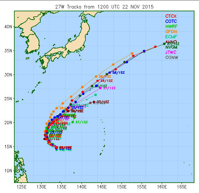


algae888- Advanced Forecaster

- Posts : 5311
Reputation : 46
Join date : 2013-02-05
Age : 61
Location : mt. vernon, new york
 Re: Long Range Thread 9.0
Hi all. Here is a post from WeatherGun, aka Miguel, from another weather forum about the state of our Stratosphere. Isotherm, aka Tom, agrees with him that the SSWE (sudden stratospheric warming event) may occur earlier than normal this year. Right now they are thinking around Christmas time to early January.
"This is the ECMWF stratosphere forecast from the Berlin site overnight. Some decent warming at 10 hPa showing up over Eurasia now at 7 days. Alongside geopotential and heat flux, momentum flux (UV) is also very high in the upper-stratosphere. Which is quite impressive now. But this is forecast to subside by 10 days. EP vectors shift poleward towards the end of the forecast, But EP flux appears very weak. This isn't a surprise to me though.
All in all, everything pretty much on track. This is still a slow step down process with more attacks likely due increasing Eurasian snowcover, tropical forcing, mountain torques,etc through December. Eventually resulting to the pattern changes we want to see at 500mb by January"


_________________
_______________________________________________________________________________________________________
CLICK HERE to view NJ Strong Snowstorm Classifications
 Re: Long Range Thread 9.0
I am not as knowledgeable about the Stratosphere but understand the basics. To see two respected forecasters be this optimistic about it is great news. For those who are wondering what the impact is, it means our AO could go negative sooner than expected. The Stratospheric PV splits into two which in turn weakens the Troposphere PV. This weakening allows the PV to displace itself from the Arctic.
_________________
_______________________________________________________________________________________________________
CLICK HERE to view NJ Strong Snowstorm Classifications
 Re: Long Range Thread 9.0
So in other words cold! I need a new jacket lol

jmanley32- Senior Enthusiast

- Posts : 20517
Reputation : 108
Join date : 2013-12-12
Age : 42
Location : Yonkers, NY
 Re: Long Range Thread 9.0
The CMC develops a wave of low pressure post cold frontal passage Saturday night early Sunday morning give snow to the northern and western suburbs into Connecticut the models were hinting at this late last week but seem to have lost it over the weekend and yesterday. wondering if this will come back on the models in the next several days

algae888- Advanced Forecaster

- Posts : 5311
Reputation : 46
Join date : 2013-02-05
Age : 61
Location : mt. vernon, new york
 Re: Long Range Thread 9.0
Yay, I m going to be in CT : ) And wow GFS has storm after storm, 5th, 8th yeah its all fantasy land but as stated hoping this is our winter ahead.

jmanley32- Senior Enthusiast

- Posts : 20517
Reputation : 108
Join date : 2013-12-12
Age : 42
Location : Yonkers, NY
 Re: Long Range Thread 9.0
Perhaps this is a weenie thought because it's a reference to the GFS op, but it is something I have noticed lately. There seems to be some runs showing east based -NAO ridging and ridging near the Bering Sea. If that did happen...it would help keep at least eastern Canada cooler with that vortex hanging around. I suppose it isn't outlandish to think a high nosing down can help deliver just enough cold should timing work out. Even the EC ensembles are showing neutral height anomalies near the arctic which implies some members may not have a black hole there. Anyways, just food for thought I guess.
_________________
Mugs
AKA:King: Snow Weenie
Self Proclaimed
WINTER 2014-15 : 55.12" +.02 for 6 coatings (avg. 35")
WINTER 2015-16 Total - 29.8" (Avg 35")
WINTER 2016-17 : 39.5" so far

amugs- Advanced Forecaster - Mod

- Posts : 15093
Reputation : 213
Join date : 2013-01-07
Age : 54
Location : Hillsdale,NJ
 Re: Long Range Thread 9.0
The official forecast from the National Weather Service for my area for Sunday night and Monday now has a chance of rain and snow @ 30 + 40% so maybe there will be a wave of low pressure coming through after the cold front passes any thoughts for Frank or Scott

algae888- Advanced Forecaster

- Posts : 5311
Reputation : 46
Join date : 2013-02-05
Age : 61
Location : mt. vernon, new york
 Re: Long Range Thread 9.0
algae888 wrote:The official forecast from the National Weather Service for my area for Sunday night and Monday now has a chance of rain and snow @ 30 + 40% so maybe there will be a wave of low pressure coming through after the cold front passes any thoughts for Frank or Scott
Honestly other than some light rain Im not that impressed Al for the Monday time frame for most if not all of our coverage area. I think the flow out ahead of the ULL coming out of the west is too progressive for anything other than maybe a weak wave of LP to develop along the frontal boundary. If you recall last March and the above nomal snowfall for especially the coast, this stalling frontal boundary with weak waves of LP developing along it was a key setup for that. One of the problems with a set up like that now is there really isn't much of a temp gradient with this set up which was they key to why that worked so well back in March (ie: enhanced lift and QPF secondary to the baroclinic zone). IF a LP develops, which I don't think happens anyway, it will be very weak. Too weak to generate its own cold air. And then of course no sooner does the cold front pass does the set up I note below take place giving the cold air the boot fairly quickly as its only a day or two later.
Regarding the Dec 1st set up... Im getting less and less impressed with this as well. Obv there is time for things to trend but I am not all that excited about this threat at this time.
 " />
" />_________________
"In weather and in life, there's no winning and losing; there's only winning and learning."
WINTER 2012/2013 TOTALS 43.65"WINTER 2017/2018 TOTALS 62.85" WINTER 2022/2023 TOTALS 4.9"
WINTER 2013/2014 TOTALS 64.85"WINTER 2018/2019 TOTALS 14.25" WINTER 2023/2024 TOTALS 13.1"
WINTER 2014/2015 TOTALS 71.20"WINTER 2019/2020 TOTALS 6.35"
WINTER 2015/2016 TOTALS 35.00"WINTER 2020/2021 TOTALS 37.75"
WINTER 2016/2017 TOTALS 42.25"WINTER 2021/2022 TOTALS 31.65"

sroc4- Admin

- Posts : 8331
Reputation : 301
Join date : 2013-01-07
Location : Wading River, LI
Page 4 of 40 •  1, 2, 3, 4, 5 ... 22 ... 40
Page 4 of 40
Permissions in this forum:
You cannot reply to topics in this forum|
|
|

 Home
Home