
 Search
Tracking Hurricane Irma: Part 2
Page 7 of 21 •  1 ... 6, 7, 8 ... 14 ... 21
 ![]()
Re: Tracking Hurricane Irma: Part 2
![]() by algae888 Thu Sep 07, 2017 5:58 am
by algae888 Thu Sep 07, 2017 5:58 am
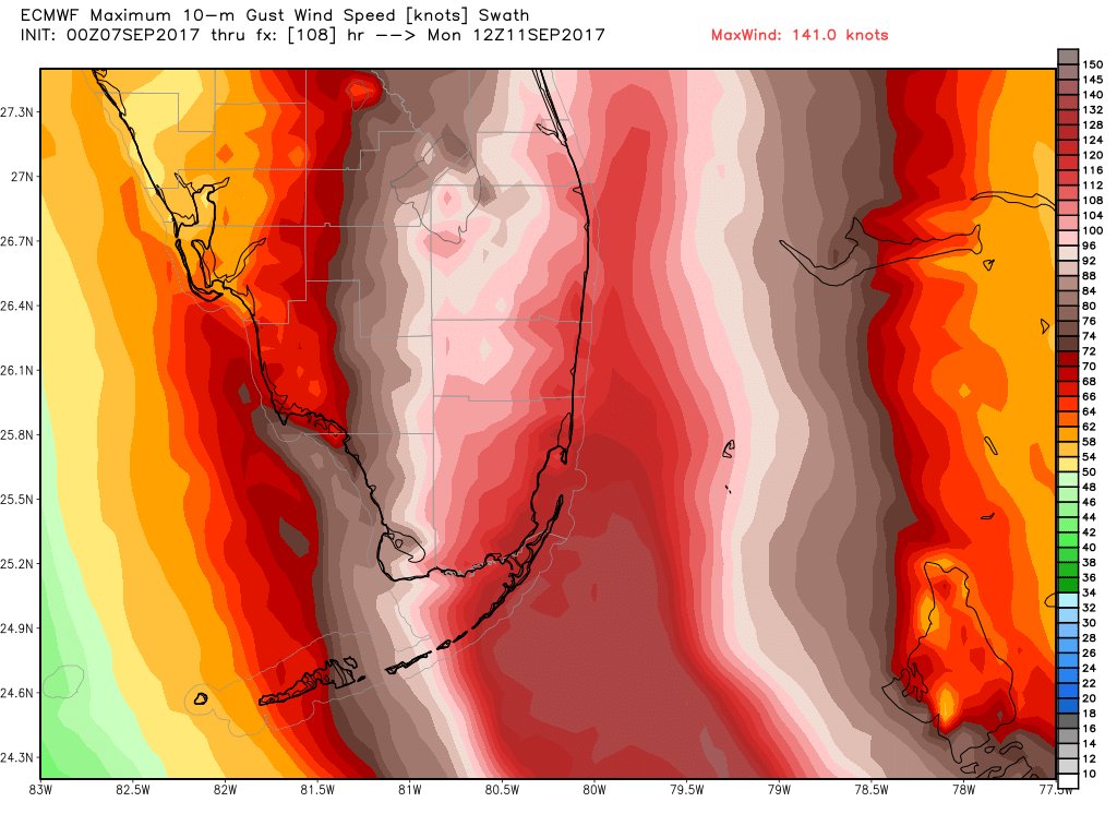
The initial motion is 290/15. The hurricane is currently being steered by the subtropical ridge to the north, and for the next 48 h or so this motion is expected to continue with a decrease in the forward speed. After 48 h, a mid- to upper-level trough digging into the eastern United States is expected to create a break in the ridge and allow Irma to turn northward. The timing of the turn is the most important question and one still filled with uncertainty. The UKMET, UK Ensemble mean, and the NAVGEM are the models showing the latest turn, and they forecast Irma to move into the southeastern Gulf of Mexico and near the west coast of the Florida Peninsula. The ECMWF and ECMWF Ensemble mean are in the middle of the model pack and show Irma moving over the southeastern portion of the Florida Peninsula. The GFS, Canadian, and GFS Ensemble mean show the earliest turn and show Irma moving east of the coast of Florida toward the southeastern United States. The new forecast track will best follow the ECMWF, as well as the Florida State Superensemble and the HFIP Corrected Consensus, and it calls for the center to move over portions of the southeastern Florida Peninsula between 72-96 h and then across the Atlantic into southern South Carolina by 120 h. Users are again reminded not to focus on the exact track since the average NHC track errors at days 3, 4, and 5 are about 120, 175, and 225 miles, respectively.
algae888- Advanced Forecaster

- Posts : 5311
Join date : 2013-02-05
Re: Tracking Hurricane Irma: Part 2
![]() by dkodgis Thu Sep 07, 2017 6:12 am
by dkodgis Thu Sep 07, 2017 6:12 am
dkodgis- Senior Enthusiast

- Posts : 2505
Join date : 2013-12-29
Re: Tracking Hurricane Irma: Part 2
![]() by Guest Thu Sep 07, 2017 6:23 am
by Guest Thu Sep 07, 2017 6:23 am
Guest- Guest
Re: Tracking Hurricane Irma: Part 2
![]() by amugs Thu Sep 07, 2017 7:43 am
by amugs Thu Sep 07, 2017 7:43 am
TheAresian wrote:It looks like the 6z GFS pulls it west about 6 hours earlier than the 0z did. It makes landfall further south along the coast of South Carolina. Still the same strength though. Damn, this storm just refuses to weaken.
She is on a mission - Recon has 919/18 MB and 175mph SW still
She is Petty - WONT BACK DOWN!!
IF YUO ANYONE ON TEHE C OF FLA THEY NEED TO GET THE H OUT OF TOWN IF NOT DONE SO ESPECIALLY S FLA
_________________
Mugs
AKA:King: Snow Weenie
Self Proclaimed
WINTER 2014-15 : 55.12" +.02 for 6 coatings (avg. 35")
WINTER 2015-16 Total - 29.8" (Avg 35")
WINTER 2016-17 : 39.5" so far

amugs- Advanced Forecaster - Mod

- Posts : 15093
Reputation : 213
Join date : 2013-01-07
Age : 54
Location : Hillsdale,NJ
Re: Tracking Hurricane Irma: Part 2
![]() by Guest Thu Sep 07, 2017 7:49 am
by Guest Thu Sep 07, 2017 7:49 am
Guest- Guest
Re: Tracking Hurricane Irma: Part 2
![]() by dkodgis Thu Sep 07, 2017 8:03 am
by dkodgis Thu Sep 07, 2017 8:03 am

dkodgis- Senior Enthusiast
- Posts : 2505
Reputation : 98
Join date : 2013-12-29
Re: Tracking Hurricane Irma: Part 2
![]() by Frank_Wx Thu Sep 07, 2017 9:14 am
by Frank_Wx Thu Sep 07, 2017 9:14 am
_________________
_______________________________________________________________________________________________________
CLICK HERE to view NJ Strong Snowstorm Classifications

Frank_Wx- Godzilla Seeker

- Posts : 21305
Reputation : 328
Join date : 2013-01-05
Age : 31
Location : Jersey City, NJ -

Re: Tracking Hurricane Irma: Part 2
![]() by weatherwatchermom Thu Sep 07, 2017 9:27 am
by weatherwatchermom Thu Sep 07, 2017 9:27 am
Frank_Wx wrote:If anyone has family in the Southeast and they're seeking information, please ask here and I will work on answering them.
Hi Frank..I have an Aunt and cousin in Pompano Beach fl...tried getting in touch this morning..they originally were going to stay...but not sure what is going on today...and my best friend has an aunt 78 who will not leave her house in the Keys. I also have strong connections to Beaufort NC...thank you Frank..in NC..they are calling for high wind and a lot of rain...not hyping this storm Thank you!!

weatherwatchermom- Senior Enthusiast
- Posts : 3750
Reputation : 77
Join date : 2014-11-25
Age : 60
Location : Hazlet Township, NJ
Re: Tracking Hurricane Irma: Part 2
![]() by Grselig Thu Sep 07, 2017 9:35 am
by Grselig Thu Sep 07, 2017 9:35 am

Grselig- Senior Enthusiast
- Posts : 1408
Reputation : 140
Join date : 2013-03-04
Age : 54
Location : Wayne NJ
Re: Tracking Hurricane Irma: Part 2
![]() by Disneyprincess1592 Thu Sep 07, 2017 9:40 am
by Disneyprincess1592 Thu Sep 07, 2017 9:40 am
Disneyprincess1592- Posts : 34
Reputation : 0
Join date : 2017-08-31
Re: Tracking Hurricane Irma: Part 2
![]() by weatherwatchermom Thu Sep 07, 2017 10:13 am
by weatherwatchermom Thu Sep 07, 2017 10:13 am
weatherwatchermom- Senior Enthusiast
- Posts : 3750
Reputation : 77
Join date : 2014-11-25
Age : 60
Location : Hazlet Township, NJ
Re: Tracking Hurricane Irma: Part 2
![]() by Frank_Wx Thu Sep 07, 2017 10:17 am
by Frank_Wx Thu Sep 07, 2017 10:17 am
weatherwatchermom wrote:Frank_Wx wrote:If anyone has family in the Southeast and they're seeking information, please ask here and I will work on answering them.
Hi Frank..I have an Aunt and cousin in Pompano Beach fl...tried getting in touch this morning..they originally were going to stay...but not sure what is going on today...and my best friend has an aunt 78 who will not leave her house in the Keys. I also have strong connections to Beaufort NC...thank you Frank..in NC..they are calling for high wind and a lot of rain...not hyping this storm Thank you!!
Pompano Beach: Evacuate immediately. The eye of Irma could pass west or directly over them. Both catastrophic scenarios.
Keys: Evacuation not mandatory but suggested. Unless track changes, Irma will pass east of these islands saving them from severe storm surge and torrential rains. They will still see heavy rain and high wind though. This is a mammoth Cat 5 hurricane against small islands. Common sense says to leave. If track of Irma goes more west, then the islands become a mandatory evacuation zone.
Beaufort, NC: Evacuate immediately. Although landfall is likely to be south of this area, they will be on the North-Northeast quadrant of the storm where surge will be at its worst. Torrential rains are also expected. The surge alone warrants evacuation. Irma could still be a Cat 4 hurricane when it makes landfall in GA/SC.
Grselig wrote:I have an elderly uncle in Delray Beach, FL. Trying to get in touch with him. I'm getting very concerned. evacuation at this age and state of mind is difficult
Delray Beach: Evacuate immediately. The eye of Irma could pass west or directly over them. Both catastrophic scenarios.
Disneyprincess1592 wrote:I personally am in Orlando Florida and my in laws are in deltona
Orlando: At this time, I am thinking the eye passes east of here and your forecast is similar to that of the Florida Keys. Heavy rain and high wind, but not to the point of evacuating. Keep an eye on the track. A wobble west could put you in greater danger.
_________________
_______________________________________________________________________________________________________
CLICK HERE to view NJ Strong Snowstorm Classifications
Frank_Wx- Godzilla Seeker
- Posts : 21305
Reputation : 328
Join date : 2013-01-05
Age : 31
Location : Jersey City, NJ -
Re: Tracking Hurricane Irma: Part 2
![]() by Guest Thu Sep 07, 2017 10:23 am
by Guest Thu Sep 07, 2017 10:23 am
Guest- Guest
Re: Tracking Hurricane Irma: Part 2
![]() by Disneyprincess1592 Thu Sep 07, 2017 10:39 am
by Disneyprincess1592 Thu Sep 07, 2017 10:39 am
Disneyprincess1592- Posts : 34
Reputation : 0
Join date : 2017-08-31
Re: Tracking Hurricane Irma: Part 2
![]() by CPcantmeasuresnow Thu Sep 07, 2017 10:44 am
by CPcantmeasuresnow Thu Sep 07, 2017 10:44 am
Thanks as always for your help. I have close family in the following places in the order that they will be affected:
Key Largo Fla - northernmost Keys
Miami Fla
Greenville SC
Atlanta - NE suburbs
Myrtle Beach SC
Sorry for the long list but I come from a big family and they all keep migrating southeast.

CPcantmeasuresnow- Wx Statistician Guru

- Posts : 7274
Reputation : 230
Join date : 2013-01-07
Age : 103
Location : Eastern Orange County, NY
Re: Tracking Hurricane Irma: Part 2
![]() by jake732 Thu Sep 07, 2017 10:46 am
by jake732 Thu Sep 07, 2017 10:46 am

jake732- Pro Enthusiast

- Posts : 449
Reputation : 0
Join date : 2016-01-03
Location : lakewood, nj -
Re: Tracking Hurricane Irma: Part 2
![]() by Grselig Thu Sep 07, 2017 10:51 am
by Grselig Thu Sep 07, 2017 10:51 am
Frank_Wx wrote:weatherwatchermom wrote:Frank_Wx wrote:If anyone has family in the Southeast and they're seeking information, please ask here and I will work on answering them.
Hi Frank..I have an Aunt and cousin in Pompano Beach fl...tried getting in touch this morning..they originally were going to stay...but not sure what is going on today...and my best friend has an aunt 78 who will not leave her house in the Keys. I also have strong connections to Beaufort NC...thank you Frank..in NC..they are calling for high wind and a lot of rain...not hyping this storm Thank you!!
Pompano Beach: Evacuate immediately. The eye of Irma could pass west or directly over them. Both catastrophic scenarios.
Keys: Evacuation not mandatory but suggested. Unless track changes, Irma will pass east of these islands saving them from severe storm surge and torrential rains. They will still see heavy rain and high wind though. This is a mammoth Cat 5 hurricane against small islands. Common sense says to leave. If track of Irma goes more west, then the islands become a mandatory evacuation zone.
Beaufort, NC: Evacuate immediately. Although landfall is likely to be south of this area, they will be on the North-Northeast quadrant of the storm where surge will be at its worst. Torrential rains are also expected. The surge alone warrants evacuation. Irma could still be a Cat 4 hurricane when it makes landfall in GA/SC.Grselig wrote:I have an elderly uncle in Delray Beach, FL. Trying to get in touch with him. I'm getting very concerned. evacuation at this age and state of mind is difficult
Delray Beach: Evacuate immediately. The eye of Irma could pass west or directly over them. Both catastrophic scenarios.Disneyprincess1592 wrote:I personally am in Orlando Florida and my in laws are in deltona
Orlando: At this time, I am thinking the eye passes east of here and your forecast is similar to that of the Florida Keys. Heavy rain and high wind, but not to the point of evacuating. Keep an eye on the track. A wobble west could put you in greater danger.
Frank - Thanks!
Grselig- Senior Enthusiast
- Posts : 1408
Reputation : 140
Join date : 2013-03-04
Age : 54
Location : Wayne NJ
Re: Tracking Hurricane Irma: Part 2
![]() by Nyi1058 Thu Sep 07, 2017 10:55 am
by Nyi1058 Thu Sep 07, 2017 10:55 am
Named Gary . They are in Boco Roton. Claim they are riding it out instead of heading north to the villages near Orlando
Nyi1058- Posts : 86
Reputation : 3
Join date : 2013-12-04
Age : 49
Location : Port Jefferson Long Island
Re: Tracking Hurricane Irma: Part 2
![]() by HectorO Thu Sep 07, 2017 11:02 am
by HectorO Thu Sep 07, 2017 11:02 am

HectorO- Pro Enthusiast
- Posts : 959
Reputation : 27
Join date : 2013-01-11
Re: Tracking Hurricane Irma: Part 2
![]() by algae888 Thu Sep 07, 2017 11:14 am
by algae888 Thu Sep 07, 2017 11:14 am
Yes Jake the 12 znam corrected West now in line with the other reliable models devastating for southern Florida especially along the east coast. Also notice how much she is slow down when she gets near Floridajake732 wrote:Good bye half of Florida on the 12z NAM

algae888- Advanced Forecaster
- Posts : 5311
Reputation : 46
Join date : 2013-02-05
Age : 61
Location : mt. vernon, new york
Re: Tracking Hurricane Irma: Part 2
![]() by jmanley32 Thu Sep 07, 2017 11:28 am
by jmanley32 Thu Sep 07, 2017 11:28 am

jmanley32- Senior Enthusiast
- Posts : 20517
Reputation : 108
Join date : 2013-12-12
Age : 42
Location : Yonkers, NY
Re: Tracking Hurricane Irma: Part 2
![]() by bobjohnsonforthehall Thu Sep 07, 2017 11:29 am
by bobjohnsonforthehall Thu Sep 07, 2017 11:29 am

bobjohnsonforthehall- Posts : 311
Reputation : 19
Join date : 2016-10-02
Location : Flemington NJ
Re: Tracking Hurricane Irma: Part 2
![]() by sroc4 Thu Sep 07, 2017 11:31 am
by sroc4 Thu Sep 07, 2017 11:31 am
_________________
"In weather and in life, there's no winning and losing; there's only winning and learning."
WINTER 2012/2013 TOTALS 43.65"WINTER 2017/2018 TOTALS 62.85" WINTER 2022/2023 TOTALS 4.9"
WINTER 2013/2014 TOTALS 64.85"WINTER 2018/2019 TOTALS 14.25" WINTER 2023/2024 TOTALS 13.1"
WINTER 2014/2015 TOTALS 71.20"WINTER 2019/2020 TOTALS 6.35"
WINTER 2015/2016 TOTALS 35.00"WINTER 2020/2021 TOTALS 37.75"
WINTER 2016/2017 TOTALS 42.25"WINTER 2021/2022 TOTALS 31.65"

sroc4- Admin
- Posts : 8331
Reputation : 301
Join date : 2013-01-07
Location : Wading River, LI
Re: Tracking Hurricane Irma: Part 2
![]() by Frank_Wx Thu Sep 07, 2017 11:36 am
by Frank_Wx Thu Sep 07, 2017 11:36 am
The 12z NAM is a very scary solution. Up through the middle of southern FL, which means Miami and all of eastern FL are under catastrophic rain, wind, and surge.

_________________
_______________________________________________________________________________________________________
CLICK HERE to view NJ Strong Snowstorm Classifications
Frank_Wx- Godzilla Seeker
- Posts : 21305
Reputation : 328
Join date : 2013-01-05
Age : 31
Location : Jersey City, NJ -
Re: Tracking Hurricane Irma: Part 2
![]() by Frank_Wx Thu Sep 07, 2017 11:37 am
by Frank_Wx Thu Sep 07, 2017 11:37 am


_________________
_______________________________________________________________________________________________________
CLICK HERE to view NJ Strong Snowstorm Classifications
Frank_Wx- Godzilla Seeker
- Posts : 21305
Reputation : 328
Join date : 2013-01-05
Age : 31
Location : Jersey City, NJ -
Re: Tracking Hurricane Irma: Part 2
![]() by SoulSingMG Thu Sep 07, 2017 11:40 am
by SoulSingMG Thu Sep 07, 2017 11:40 am

SoulSingMG- Senior Enthusiast
- Posts : 2853
Reputation : 74
Join date : 2013-12-11
Location : Long Island City, NY
Re: Tracking Hurricane Irma: Part 2
![]() by bobjohnsonforthehall Thu Sep 07, 2017 11:59 am
by bobjohnsonforthehall Thu Sep 07, 2017 11:59 am
bobjohnsonforthehall- Posts : 311
Reputation : 19
Join date : 2016-10-02
Location : Flemington NJ
Page 7 of 21 • 1 ... 6, 7, 8 ... 14 ... 21 ![]()
|
|
|