
 Search
Tracking Hurricane Irma: Part 2
Page 1 of 21 • 1, 2, 3 ... 11 ... 21 ![]()

Tracking Hurricane Irma: Part 2
![]() by Frank_Wx Wed Sep 06, 2017 8:35 am
by Frank_Wx Wed Sep 06, 2017 8:35 am
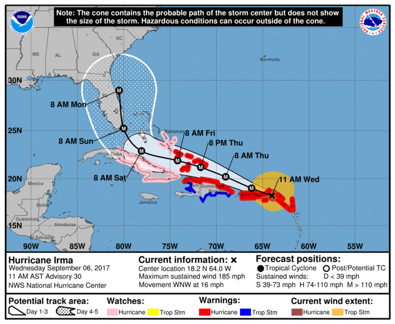
A renewed thread on Irma to provide the latest updates. I'm sure members on here have family who reside in Florida or parts of the SE Coast / Mid-Atlantic who could use valuable information.

A Florida landfall is looking less likely. There was a noticeable shift east in Irma's track on yesterday's and this morning's model runs. It is safe to say Gulf coast landfall is off the table. Yesterday, I felt out to sea was off the table too, and for the most part I think it is, but there are some Ensemble members that try to take Irma out to sea as they recognize a weaker block to its Northeast.

The GFS has actually been most consistent in NOT tracking Irma into Hispaniola/Cuba and keeping her on a northern track. The EURO last night caved to the GFS in the sense it does not take Irma into Cuba. Therefore, the EURO also keeps Irma east of FL and makes landfall in the GA/SC boarder. On the image above, you will see that the trough is trending stronger indicative by the dark shade of blue over the Ohio Valley / Northeast. The overall trough seems more expansive which suggests Irma will feel its effects and indeed make that sharp turn to the north. This is another reason why Irma seems likely to avoid Cuba, meaning she will remain a very strong and dangerous Hurricane. I'm not sure if she will maintain her Cat 5 status for her entire duration until landfall, but there is a good chance she will. There will be occasional weakening as she undergoes ERC (eye replacement cycle) but I think it will be semantics by that point.

As mentioned, 06z GEFS have some members that take Irma out to sea. The combination of a weaker High Pressure over Bermuda and a stronger trough that allows Irma to come north earlier, give her some room to head out to sea. However, there are other pieces at play that will try to lure Irma into the U.S. for landfall. There is upper air energy on the backside of the trough that tries to phase into the storm. Instead of phasing, what's most likely to happen is an upper level low will form and try to pivot Irma into the U.S. This is where the forecast becomes very difficult. If the ULL (upper level low) forms in the Mid-Atlantic as opposed to the Southeast, then Irma has a path to make landfall awfully close to our area. Most likely, landfall would be in the Mid-Atlantic but you can see there are few GEFS members that track Irma over our area (but no direct landfall!!).

She looks powerful again this morning.
I say we need yet another day to figure out Irma's destiny. Trends suggest a track east of FL with landfall into the Carolina's. But out to sea is back on the table it seems, and so does a further north track into our area though I do NOT believe direct landfall here is possible. If Irma does make it this far north, she obviously will not be a Cat 5 hurricane. She may not even be a Hurricane. But those details are not yet available.
_________________
_______________________________________________________________________________________________________
CLICK HERE to view NJ Strong Snowstorm Classifications

Frank_Wx- Godzilla Seeker

- Posts : 21305
Reputation : 328
Join date : 2013-01-05
Age : 31
Location : Jersey City, NJ -

Re: Tracking Hurricane Irma: Part 2
![]() by Frank_Wx Wed Sep 06, 2017 8:36 am
by Frank_Wx Wed Sep 06, 2017 8:36 am
GOOD MORNING!!
Well the trough digging in is strong and vigorous. The next 48hrs will be telling. Normally you wouldn't be using the NAM as a model to predict the fate of a tropical system but in this case I think we can. One of the most important players, if not the most important regarding where the turn occurs, in the entire equation has been the mean trough that is digging into the central plains and Ohio River alley.
This link is an amazing sat loop to look at:
=8&opacity[0]=1&hidden[0]=0&pause=0&slider=-1&hide_controls=1&mouse_draw=0&s=rammb-slider]http://rammb-slider.cira.colostate.edu/?sat=goes-16&sec=full_disk&x=11312&y=5480&z=2&im=60&ts=1&st=0&et=0&speed=130&motion=loop&map=1&lat=0&p%5B0%5D=8&opacity%5B0%5D=1&hidden%5B0%5D=0&pause=0&slider=-1&hide_controls=1&mouse_draw=0&s=rammb-slider
It is an anomalously strong trough in response to the recurving typhoon. In past experiences the NAM has done exceptionally well with handling of such strong dynamic set ups for the east coast so I am using it in conjunction with the rest of the global models to see the true dynamics of the trough and ridging features. It is def the northern and eastern most track soln, but may be leading the way here for additional trends east based on the below H5 set up. I would argue that extrapolated out Irma would Cont N fromhere; then maybe even a tad NNE before interacting with the trailing s/w; then being captured before being pulled back NNW into the coast on this run.
Of course the wiper effect could come into play and a shift back west is certainly possible, but it appears clear to me based off model trends, and current observations it the eastern half of Fla and points N and E of that that we need to focus on. And yes we are def still in play up here from some kind of effects from Irma. Not sure what that ceiling is regarding effects, but again within the next 48hrs we will know ALOT.
Hey....WE TRACK!!!


_________________
_______________________________________________________________________________________________________
CLICK HERE to view NJ Strong Snowstorm Classifications
Frank_Wx- Godzilla Seeker
- Posts : 21305
Reputation : 328
Join date : 2013-01-05
Age : 31
Location : Jersey City, NJ -
Re: Tracking Hurricane Irma: Part 2
![]() by jmanley32 Wed Sep 06, 2017 9:10 am
by jmanley32 Wed Sep 06, 2017 9:10 am

jmanley32- Senior Enthusiast

- Posts : 20512
Reputation : 108
Join date : 2013-12-12
Age : 42
Location : Yonkers, NY
Re: Tracking Hurricane Irma: Part 2
![]() by mikeypizano Wed Sep 06, 2017 9:15 am
by mikeypizano Wed Sep 06, 2017 9:15 am

mikeypizano- Pro Enthusiast

- Posts : 1118
Reputation : 66
Join date : 2017-01-05
Age : 35
Location : Wilkes-Barre/Scranton, PA
Re: Tracking Hurricane Irma: Part 2
![]() by weatherwatchermom Wed Sep 06, 2017 9:28 am
by weatherwatchermom Wed Sep 06, 2017 9:28 am

weatherwatchermom- Senior Enthusiast
- Posts : 3733
Reputation : 77
Join date : 2014-11-25
Age : 60
Location : Hazlet Township, NJ
Re: Tracking Hurricane Irma: Part 2
![]() by Frank_Wx Wed Sep 06, 2017 9:35 am
by Frank_Wx Wed Sep 06, 2017 9:35 am


_________________
_______________________________________________________________________________________________________
CLICK HERE to view NJ Strong Snowstorm Classifications
Frank_Wx- Godzilla Seeker
- Posts : 21305
Reputation : 328
Join date : 2013-01-05
Age : 31
Location : Jersey City, NJ -
Re: Tracking Hurricane Irma: Part 2
![]() by essexcountypete Wed Sep 06, 2017 9:40 am
by essexcountypete Wed Sep 06, 2017 9:40 am
https://twitter.com/kurtsiegelin/status/905403206121005058
A lot of news, images and video here...
https://www.theguardian.com/world/live/2017/sep/06/hurricane-irma-caribbean-islands-category-5-storm

essexcountypete- Pro Enthusiast
- Posts : 783
Reputation : 12
Join date : 2013-12-09
Location : Bloomfield, NJ
Re: Tracking Hurricane Irma: Part 2
![]() by nutleyblizzard Wed Sep 06, 2017 10:17 am
by nutleyblizzard Wed Sep 06, 2017 10:17 am

nutleyblizzard- Senior Enthusiast
- Posts : 1952
Reputation : 41
Join date : 2014-01-30
Age : 58
Location : Nutley, new jersey
Re: Tracking Hurricane Irma: Part 2
![]() by sabamfa Wed Sep 06, 2017 10:23 am
by sabamfa Wed Sep 06, 2017 10:23 am
sabamfa- Pro Enthusiast
- Posts : 246
Reputation : 2
Join date : 2013-11-05
Age : 37
Location : Wayne, NJ
Re: Tracking Hurricane Irma: Part 2
![]() by sroc4 Wed Sep 06, 2017 10:27 am
by sroc4 Wed Sep 06, 2017 10:27 am
sabamfa wrote:Booked a very expensive flight for my father in law last night to get out of Fort Myers Beach, Fl (island on the golf coast). We can cancel until 5:30 tonight or so. He leaves Friday morning. Thoughts?
Wait for all the 12z runs to finish...euro done by about 2-2:30 Euro ensebles by about 4
_________________
"In weather and in life, there's no winning and losing; there's only winning and learning."
WINTER 2012/2013 TOTALS 43.65"WINTER 2017/2018 TOTALS 62.85" WINTER 2022/2023 TOTALS 4.9"
WINTER 2013/2014 TOTALS 64.85"WINTER 2018/2019 TOTALS 14.25" WINTER 2023/2024 TOTALS 13.1"
WINTER 2014/2015 TOTALS 71.20"WINTER 2019/2020 TOTALS 6.35"
WINTER 2015/2016 TOTALS 35.00"WINTER 2020/2021 TOTALS 37.75"
WINTER 2016/2017 TOTALS 42.25"WINTER 2021/2022 TOTALS 31.65"

sroc4- Admin
- Posts : 8331
Reputation : 301
Join date : 2013-01-07
Location : Wading River, LI
Re: Tracking Hurricane Irma: Part 2
![]() by RJB8525 Wed Sep 06, 2017 10:28 am
by RJB8525 Wed Sep 06, 2017 10:28 am
sabamfa wrote:Booked a very expensive flight for my father in law last night to get out of Fort Myers Beach, Fl (island on the golf coast). We can cancel until 5:30 tonight or so. He leaves Friday morning. Thoughts?
lol FL is boarding up all areas like that..

RJB8525- Senior Enthusiast
- Posts : 1994
Reputation : 28
Join date : 2013-02-06
Age : 38
Location : Hackettstown, NJ
Re: Tracking Hurricane Irma: Part 2
![]() by Frank_Wx Wed Sep 06, 2017 10:29 am
by Frank_Wx Wed Sep 06, 2017 10:29 am
sabamfa wrote:Booked a very expensive flight for my father in law last night to get out of Fort Myers Beach, Fl (island on the golf coast). We can cancel until 5:30 tonight or so. He leaves Friday morning. Thoughts?
Wait until this afternoons runs of models come in, but Fort Myers Beach is on the WEST side of Florida. Irma no longer seems to be tracking on Florida's west side. She either wants to make landfall in east Florida or stay off its coast entirely (no landfall). However, he would still see Hurricane force winds and some surge even if Irma tracks east of there. Maybe you are better off finding a hotel inland (off the island) and away from the east coast of Florida? Could be cheaper than a flight. But a flight out is obviously safest bet.
_________________
_______________________________________________________________________________________________________
CLICK HERE to view NJ Strong Snowstorm Classifications
Frank_Wx- Godzilla Seeker
- Posts : 21305
Reputation : 328
Join date : 2013-01-05
Age : 31
Location : Jersey City, NJ -
Re: Tracking Hurricane Irma: Part 2
![]() by aiannone Wed Sep 06, 2017 10:33 am
by aiannone Wed Sep 06, 2017 10:33 am
_________________
-Alex Iannone-

aiannone- Senior Enthusiast - Mod

- Posts : 4813
Reputation : 92
Join date : 2013-01-07
Location : Saint James, LI (Northwest Suffolk Co.)
Re: Tracking Hurricane Irma: Part 2
![]() by sabamfa Wed Sep 06, 2017 10:34 am
by sabamfa Wed Sep 06, 2017 10:34 am
sroc4 wrote:sabamfa wrote:Booked a very expensive flight for my father in law last night to get out of Fort Myers Beach, Fl (island on the golf coast). We can cancel until 5:30 tonight or so. He leaves Friday morning. Thoughts?
Wait for all the 12z runs to finish...euro done by about 2-2:30 Euro ensebles by about 4
Thanks!
RJB8525 wrote:sabamfa wrote:Booked a very expensive flight for my father in law last night to get out of Fort Myers Beach, Fl (island on the golf coast). We can cancel until 5:30 tonight or so. He leaves Friday morning. Thoughts?
lol FL is boarding up all areas like that..
He's not in a mandatory evacuation at the moment and I'm not exactly down there to be able to speak with anyone that has been through this before. =\
Frank_Wx wrote:sabamfa wrote:Booked a very expensive flight for my father in law last night to get out of Fort Myers Beach, Fl (island on the golf coast). We can cancel until 5:30 tonight or so. He leaves Friday morning. Thoughts?
Wait until this afternoons runs of models come in, but Fort Myers Beach is on the WEST side of Florida. Irma no longer seems to be tracking on Florida's west side. She either wants to make landfall in east Florida or stay off its coast entirely (no landfall). However, he would still see Hurricane force winds and some surge even if Irma tracks east of there. Maybe you are better off finding a hotel inland (off the island) and away from the east coast of Florida? Could be cheaper than a flight. But a flight out is obviously safest bet.
Thanks, Frank. He has no car, so anything that relied on him traveling further than he can on a bike is out of the question. It was pretty much flight out or hope someone down there could help him if necessary.
sabamfa- Pro Enthusiast
- Posts : 246
Reputation : 2
Join date : 2013-11-05
Age : 37
Location : Wayne, NJ
Re: Tracking Hurricane Irma: Part 2
![]() by essexcountypete Wed Sep 06, 2017 10:46 am
by essexcountypete Wed Sep 06, 2017 10:46 am
https://www.nasa.gov/feature/goddard/2017/irma-atlantic-ocean
essexcountypete- Pro Enthusiast
- Posts : 783
Reputation : 12
Join date : 2013-12-09
Location : Bloomfield, NJ
Re: Tracking Hurricane Irma: Part 2
![]() by Frank_Wx Wed Sep 06, 2017 10:54 am
by Frank_Wx Wed Sep 06, 2017 10:54 am

_________________
_______________________________________________________________________________________________________
CLICK HERE to view NJ Strong Snowstorm Classifications
Frank_Wx- Godzilla Seeker
- Posts : 21305
Reputation : 328
Join date : 2013-01-05
Age : 31
Location : Jersey City, NJ -
Re: Tracking Hurricane Irma: Part 2
![]() by mikeypizano Wed Sep 06, 2017 10:58 am
by mikeypizano Wed Sep 06, 2017 10:58 am
Frank_Wx wrote:12z NAM coming in now and it looks like Irma would miss making landfall in Florida. Already made the turn north at this time frame.
Does this mean possible to come up coast more?
mikeypizano- Pro Enthusiast
- Posts : 1118
Reputation : 66
Join date : 2017-01-05
Age : 35
Location : Wilkes-Barre/Scranton, PA
Re: Tracking Hurricane Irma: Part 2
![]() by aiannone Wed Sep 06, 2017 10:59 am
by aiannone Wed Sep 06, 2017 10:59 am
_________________
-Alex Iannone-
aiannone- Senior Enthusiast - Mod
- Posts : 4813
Reputation : 92
Join date : 2013-01-07
Location : Saint James, LI (Northwest Suffolk Co.)
Re: Tracking Hurricane Irma: Part 2
![]() by RJB8525 Wed Sep 06, 2017 11:04 am
by RJB8525 Wed Sep 06, 2017 11:04 am
RJB8525- Senior Enthusiast
- Posts : 1994
Reputation : 28
Join date : 2013-02-06
Age : 38
Location : Hackettstown, NJ
Re: Tracking Hurricane Irma: Part 2
![]() by mikeypizano Wed Sep 06, 2017 11:08 am
by mikeypizano Wed Sep 06, 2017 11:08 am
RJB8525 wrote:the more it shifts..the more they are talking about landfall in FL on TV. very confusing they aren't mentioning anything different at all to the people
Is this like my local met who claimed spotty showers today?
mikeypizano- Pro Enthusiast
- Posts : 1118
Reputation : 66
Join date : 2017-01-05
Age : 35
Location : Wilkes-Barre/Scranton, PA
Re: Tracking Hurricane Irma: Part 2
![]() by RJB8525 Wed Sep 06, 2017 11:09 am
by RJB8525 Wed Sep 06, 2017 11:09 am
mikeypizano wrote:RJB8525 wrote:the more it shifts..the more they are talking about landfall in FL on TV. very confusing they aren't mentioning anything different at all to the people
Is this like my local met who claimed spotty showers today?
yep
RJB8525- Senior Enthusiast
- Posts : 1994
Reputation : 28
Join date : 2013-02-06
Age : 38
Location : Hackettstown, NJ
Re: Tracking Hurricane Irma: Part 2
![]() by amugs Wed Sep 06, 2017 11:10 am
by amugs Wed Sep 06, 2017 11:10 am
OMG this is not a good scenario but one that is coming into play - why FN SANVU the recurving Typhoon and the Scandinavian Block!!
Donna 1955 peeps - history repeating itslef

Deep trough over teh OHV is going to pull her up and in IMO
_________________
Mugs
AKA:King: Snow Weenie
Self Proclaimed
WINTER 2014-15 : 55.12" +.02 for 6 coatings (avg. 35")
WINTER 2015-16 Total - 29.8" (Avg 35")
WINTER 2016-17 : 39.5" so far

amugs- Advanced Forecaster - Mod
- Posts : 15093
Reputation : 213
Join date : 2013-01-07
Age : 54
Location : Hillsdale,NJ
Re: Tracking Hurricane Irma: Part 2
![]() by billg315 Wed Sep 06, 2017 11:12 am
by billg315 Wed Sep 06, 2017 11:12 am

billg315- Advanced Forecaster - Mod
- Posts : 4462
Reputation : 185
Join date : 2015-01-24
Age : 50
Location : Flemington, NJ
Re: Tracking Hurricane Irma: Part 2
![]() by jmanley32 Wed Sep 06, 2017 11:16 am
by jmanley32 Wed Sep 06, 2017 11:16 am
jmanley32- Senior Enthusiast
- Posts : 20512
Reputation : 108
Join date : 2013-12-12
Age : 42
Location : Yonkers, NY
Re: Tracking Hurricane Irma: Part 2
![]() by jmanley32 Wed Sep 06, 2017 11:40 am
by jmanley32 Wed Sep 06, 2017 11:40 am
jmanley32- Senior Enthusiast
- Posts : 20512
Reputation : 108
Join date : 2013-12-12
Age : 42
Location : Yonkers, NY
Page 1 of 21 • 1, 2, 3 ... 11 ... 21 ![]()
|
|
|