
 Search
February 9th-10th IVT Update
Page 1 of 7 • 1, 2, 3, 4, 5, 6, 7 ![]()

February 9th-10th IVT Update
![]() by Frank_Wx Mon Feb 08, 2016 5:52 pm
by Frank_Wx Mon Feb 08, 2016 5:52 pm
Sorry for the lack of posting today. Busy day at work! I want to provide an update on tomorrow since everyone is probably hearing different things. We know there will be an inverted trough setting up a band of snow somewhere that will drop a few inches of snow. Like I mentioned these are very difficult to pinpoint and often lead to varying forecasts. The best we can do is look at the upper levels and see if there is one area favored over another.

The GFS model pops a coastal storm southeast of the BM and takes it due east. Notice the heavier precipitation around the DC and Philly Metro areas. That is likely the "norlun" setting up. The reason why the GFS and other models are consistently showing the norlun setting up south of our area is because of where they track the 500mb low.

Here we are at 1pm Tuesday which is the same time stamp as the surface map. Look at where all the 500mb vorticity (energy) is. It is over DC Metro. As the 500mb low begins drifting south, the 500mb energy pivots N&E (below).


You can see as the 500mb energy expands into our area the surface maps begins showing lighter snow move north into NEPA, HV, NYC Metro, NNJ.
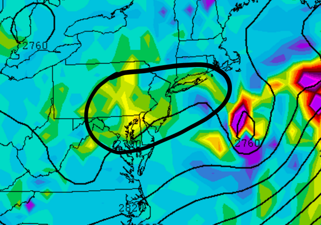
700mb frontogenesis (lift) is over a widespread area. Once the 500mb energy expands north and east it will allow snow showers and squalls to develop. At this time, I think the brunt of the snow and the norlun will stay to our south. Again, these are hard to predict but almost all guidance is showing the heaviest snow amounts south of our area.

The UKMET - which was the most bullish model bringing the norlun north into our area - shifted south today at 12z too. It still shows widespread snow showers due to the instability in our atmosphere but the heaviest snows are well south near DC.
I know Mugs mentioned the RGEM is popping a Miller-B just south of LI and throwing back moderate snow amounts into the area, but the SREFS and other major globals are not showing that so not sure how much merit it has. It's definitely worth tracking but I am leaning against it for now.

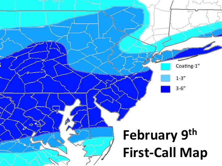
This is the map I am going with for the area. Due to the uncertainties that arise with these types of systems, I am putting most of the area under a large swath of 1-3". The general idea if the higher amounts should be contained to our south, but we can't totally discount the possibility of CNJ into NYC and LI getting into a piece of the IVT too. Be careful if you're under one of the snow squalls that develop over your area. They can drop snow FAST and deteriorate visibility.
I will have another write up out tomorrow highlighting the cold and possible snow this weekend!
Best,
Frank
_________________
_______________________________________________________________________________________________________
CLICK HERE to view NJ Strong Snowstorm Classifications

Frank_Wx- Godzilla Seeker

- Posts : 21305
Reputation : 328
Join date : 2013-01-05
Age : 31
Location : Jersey City, NJ -


jake732- Pro Enthusiast

- Posts : 449
Reputation : 0
Join date : 2016-01-03
Location : lakewood, nj -
frank 638- Senior Enthusiast

- Posts : 2825
Reputation : 37
Join date : 2016-01-01
Age : 40
Location : bronx ny
Re: February 9th-10th IVT Update
![]() by Frank_Wx Mon Feb 08, 2016 6:24 pm
by Frank_Wx Mon Feb 08, 2016 6:24 pm
.thumb.gif.e00e01aa406d0c2162c226eb4894ee07.gif)
_________________
_______________________________________________________________________________________________________
CLICK HERE to view NJ Strong Snowstorm Classifications
Frank_Wx- Godzilla Seeker
- Posts : 21305
Reputation : 328
Join date : 2013-01-05
Age : 31
Location : Jersey City, NJ -
Re: February 9th-10th IVT Update
![]() by Frank_Wx Mon Feb 08, 2016 6:25 pm
by Frank_Wx Mon Feb 08, 2016 6:25 pm
.thumb.gif.7be72753f56eb18a3603109e88632403.gif)
_________________
_______________________________________________________________________________________________________
CLICK HERE to view NJ Strong Snowstorm Classifications
Frank_Wx- Godzilla Seeker
- Posts : 21305
Reputation : 328
Join date : 2013-01-05
Age : 31
Location : Jersey City, NJ -
Re: February 9th-10th IVT Update
![]() by jake732 Mon Feb 08, 2016 6:26 pm
by jake732 Mon Feb 08, 2016 6:26 pm
jake732- Pro Enthusiast
- Posts : 449
Reputation : 0
Join date : 2016-01-03
Location : lakewood, nj -
Re: February 9th-10th IVT Update
![]() by Frank_Wx Mon Feb 08, 2016 6:26 pm
by Frank_Wx Mon Feb 08, 2016 6:26 pm

_________________
_______________________________________________________________________________________________________
CLICK HERE to view NJ Strong Snowstorm Classifications
Frank_Wx- Godzilla Seeker
- Posts : 21305
Reputation : 328
Join date : 2013-01-05
Age : 31
Location : Jersey City, NJ -
Re: February 9th-10th IVT Update
![]() by skinsfan1177 Mon Feb 08, 2016 6:27 pm
by skinsfan1177 Mon Feb 08, 2016 6:27 pm

skinsfan1177- Senior Enthusiast
- Posts : 4485
Reputation : 35
Join date : 2013-01-07
Age : 46
Location : Point Pleasant Boro
Re: February 9th-10th IVT Update
![]() by Frank_Wx Mon Feb 08, 2016 6:28 pm
by Frank_Wx Mon Feb 08, 2016 6:28 pm

Then it spread north by 4am - notice the coastal low trying to pop

If this comes to fruition, these areas will see 2-3"+ with higher amounts along the shore.
_________________
_______________________________________________________________________________________________________
CLICK HERE to view NJ Strong Snowstorm Classifications
Frank_Wx- Godzilla Seeker
- Posts : 21305
Reputation : 328
Join date : 2013-01-05
Age : 31
Location : Jersey City, NJ -
Re: February 9th-10th IVT Update
![]() by Frank_Wx Mon Feb 08, 2016 6:28 pm
by Frank_Wx Mon Feb 08, 2016 6:28 pm
skinsfan1177 wrote:And if we get a coastal it's tomorrow night correct.
Yup.
_________________
_______________________________________________________________________________________________________
CLICK HERE to view NJ Strong Snowstorm Classifications
Frank_Wx- Godzilla Seeker
- Posts : 21305
Reputation : 328
Join date : 2013-01-05
Age : 31
Location : Jersey City, NJ -
Re: February 9th-10th IVT Update
![]() by skinsfan1177 Mon Feb 08, 2016 6:42 pm
by skinsfan1177 Mon Feb 08, 2016 6:42 pm
skinsfan1177- Senior Enthusiast
- Posts : 4485
Reputation : 35
Join date : 2013-01-07
Age : 46
Location : Point Pleasant Boro
Re: February 9th-10th IVT Update
![]() by Frank_Wx Mon Feb 08, 2016 6:44 pm
by Frank_Wx Mon Feb 08, 2016 6:44 pm
skinsfan1177 wrote:What models are popping the coastal closer to coast
Just the RGEM. Impressive snow amounts.

_________________
_______________________________________________________________________________________________________
CLICK HERE to view NJ Strong Snowstorm Classifications
Frank_Wx- Godzilla Seeker
- Posts : 21305
Reputation : 328
Join date : 2013-01-05
Age : 31
Location : Jersey City, NJ -
Re: February 9th-10th IVT Update
![]() by skinsfan1177 Mon Feb 08, 2016 6:47 pm
by skinsfan1177 Mon Feb 08, 2016 6:47 pm
skinsfan1177- Senior Enthusiast
- Posts : 4485
Reputation : 35
Join date : 2013-01-07
Age : 46
Location : Point Pleasant Boro
Re: February 9th-10th IVT Update
![]() by Sanchize06 Mon Feb 08, 2016 6:53 pm
by Sanchize06 Mon Feb 08, 2016 6:53 pm


Sanchize06- Senior Enthusiast
- Posts : 1041
Reputation : 21
Join date : 2013-02-05
Location : Union Beach, NJ
Re: February 9th-10th IVT Update
![]() by Frank_Wx Mon Feb 08, 2016 6:53 pm
by Frank_Wx Mon Feb 08, 2016 6:53 pm
skinsfan1177 wrote:Tonight runs on the Meso models are huge?
I guess, but RGEM has no support anywhere. I am sleeping tonight thinking tomorrow is nothing more than 1-3" maybe more near you.
_________________
_______________________________________________________________________________________________________
CLICK HERE to view NJ Strong Snowstorm Classifications
Frank_Wx- Godzilla Seeker
- Posts : 21305
Reputation : 328
Join date : 2013-01-05
Age : 31
Location : Jersey City, NJ -
Re: February 9th-10th IVT Update
![]() by Frank_Wx Mon Feb 08, 2016 6:56 pm
by Frank_Wx Mon Feb 08, 2016 6:56 pm

_________________
_______________________________________________________________________________________________________
CLICK HERE to view NJ Strong Snowstorm Classifications
Frank_Wx- Godzilla Seeker
- Posts : 21305
Reputation : 328
Join date : 2013-01-05
Age : 31
Location : Jersey City, NJ -
Re: February 9th-10th IVT Update
![]() by rb924119 Mon Feb 08, 2016 7:00 pm
by rb924119 Mon Feb 08, 2016 7:00 pm
rb924119- Meteorologist

- Posts : 6890
Reputation : 194
Join date : 2013-02-06
Age : 32
Location : Greentown, Pa
Re: February 9th-10th IVT Update
![]() by Frank_Wx Mon Feb 08, 2016 7:10 pm
by Frank_Wx Mon Feb 08, 2016 7:10 pm
rb924119 wrote:Frank, so far we definitely have similar ideas. Did you make a thread for maps? If so, please add my map from the other thread lol
I did not. But feel free to post it here. Event is too minor for a maps thread.
_________________
_______________________________________________________________________________________________________
CLICK HERE to view NJ Strong Snowstorm Classifications
Frank_Wx- Godzilla Seeker
- Posts : 21305
Reputation : 328
Join date : 2013-01-05
Age : 31
Location : Jersey City, NJ -
Re: February 9th-10th IVT Update
![]() by amugs Mon Feb 08, 2016 7:14 pm
by amugs Mon Feb 08, 2016 7:14 pm
Last edited by amugs on Mon Feb 08, 2016 7:45 pm; edited 1 time in total
_________________
Mugs
AKA:King: Snow Weenie
Self Proclaimed
WINTER 2014-15 : 55.12" +.02 for 6 coatings (avg. 35")
WINTER 2015-16 Total - 29.8" (Avg 35")
WINTER 2016-17 : 39.5" so far

amugs- Advanced Forecaster - Mod

- Posts : 15093
Reputation : 213
Join date : 2013-01-07
Age : 54
Location : Hillsdale,NJ
Re: February 9th-10th IVT Update
![]() by rb924119 Mon Feb 08, 2016 7:21 pm
by rb924119 Mon Feb 08, 2016 7:21 pm
Frank_Wx wrote:rb924119 wrote:Frank, so far we definitely have similar ideas. Did you make a thread for maps? If so, please add my map from the other thread lol
I did not. But feel free to post it here. Event is too minor for a maps thread.
Ok, thanks!!
----------------------------
Here is my first call for tomorrow:
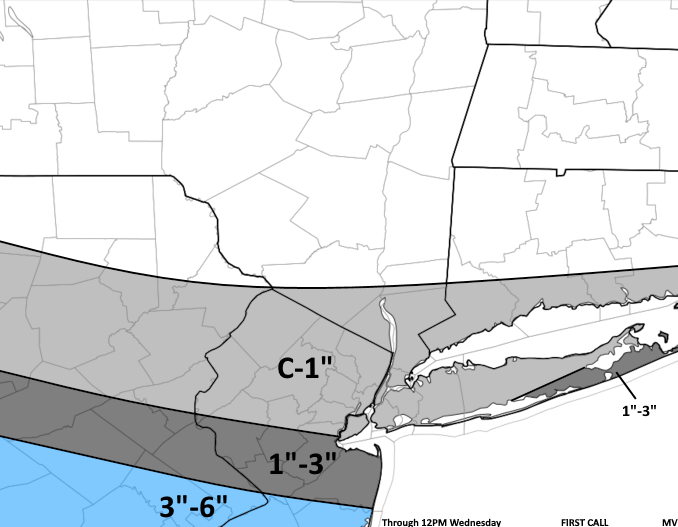
While this is only based on data through today's 12z runs, I would not be surprised if I have to add a little bit to the northern/western extent of my 3-6" zone, and maybe add a 6-9"/"locally up to 8/9" area based on what I have seen so far today. While there is still a broad consensus that the IVT stays largely south of NYC, some of the modeling is starting to hint that it may end up further north than it has been progged to, and instead of only targeting Baltimore/D.C. and possibly Philly, it looks to me like it has crawled northward to now also include central NJ and the eastern half of LI. This idea has support to me in looking at the mid-levels, as what used to be a shortwave begins to become sheared out as it rounds the base of the trough. Through PVA, it looks to hold together long enough to possibly bring some moderate snows further north. This also translates to H7, where a local closed-low beneath this shortwave/PVA may aid in enhancing omega for a period of time tomorrow midday and afternoon. Another concern of mine is that these same forcing mechanisms may be just enough to develop a relatively weak coastal system right along the coast, and almost as an extension of the IVT, when combined with the large degree of baroclinic instability between the warm Atlantic and incoming Arctic airmass. While it may be weak and the forcing mechanisms may be declining in strength, this developing surface low could throw more moisture back over its northwestern side, mainly in the form of bands with some stratiform precipitation. This will be a key feature to watch in the very short-range guidance, as well as how the mid-level energy allows the levels beneath to evolve. Just my thoughts.
rb924119- Meteorologist
- Posts : 6890
Reputation : 194
Join date : 2013-02-06
Age : 32
Location : Greentown, Pa
Re: February 9th-10th IVT Update
![]() by Frank_Wx Mon Feb 08, 2016 7:30 pm
by Frank_Wx Mon Feb 08, 2016 7:30 pm
_________________
_______________________________________________________________________________________________________
CLICK HERE to view NJ Strong Snowstorm Classifications
Frank_Wx- Godzilla Seeker
- Posts : 21305
Reputation : 328
Join date : 2013-01-05
Age : 31
Location : Jersey City, NJ -
Re: February 9th-10th IVT Update
![]() by amugs Mon Feb 08, 2016 7:54 pm
by amugs Mon Feb 08, 2016 7:54 pm
.thumb.gif.67e019896da060d365c4b19fc2452a61.gif)
_________________
Mugs
AKA:King: Snow Weenie
Self Proclaimed
WINTER 2014-15 : 55.12" +.02 for 6 coatings (avg. 35")
WINTER 2015-16 Total - 29.8" (Avg 35")
WINTER 2016-17 : 39.5" so far
amugs- Advanced Forecaster - Mod
- Posts : 15093
Reputation : 213
Join date : 2013-01-07
Age : 54
Location : Hillsdale,NJ
Re: February 9th-10th IVT Update
![]() by snow247 Mon Feb 08, 2016 7:57 pm
by snow247 Mon Feb 08, 2016 7:57 pm
Last edited by snow247 on Mon Feb 08, 2016 7:58 pm; edited 1 time in total

snow247- Pro Enthusiast
- Posts : 2417
Reputation : 0
Join date : 2014-08-27
Location : Mount Ivy, NY - Elevation 545'
Re: February 9th-10th IVT Update
![]() by skinsfan1177 Mon Feb 08, 2016 7:57 pm
by skinsfan1177 Mon Feb 08, 2016 7:57 pm
skinsfan1177- Senior Enthusiast
- Posts : 4485
Reputation : 35
Join date : 2013-01-07
Age : 46
Location : Point Pleasant Boro
Re: February 9th-10th IVT Update
![]() by jmanley32 Mon Feb 08, 2016 8:02 pm
by jmanley32 Mon Feb 08, 2016 8:02 pm

jmanley32- Senior Enthusiast
- Posts : 20517
Reputation : 108
Join date : 2013-12-12
Age : 42
Location : Yonkers, NY
Page 1 of 7 • 1, 2, 3, 4, 5, 6, 7 ![]()
|
|
|