
 Search
January 2013 Long Range Thread
Page 4 of 5 •  1, 2, 3, 4, 5
 ![]()
Re: January 2013 Long Range Thread
![]() by Frank_Wx Thu Jan 17, 2013 2:00 am
by Frank_Wx Thu Jan 17, 2013 2:00 am
Frank_Wx- Godzilla Seeker

- Posts : 21305
Join date : 2013-01-05 -

Re: January 2013 Long Range Thread
![]() by Math23x7 Thu Jan 17, 2013 2:33 am
by Math23x7 Thu Jan 17, 2013 2:33 am
Math23x7- Wx Statistician Guru

- Posts : 2379
Join date : 2013-01-08
Re: January 2013 Banter Thread
![]() by docstox12 Thu Jan 17, 2013 9:06 am
by docstox12 Thu Jan 17, 2013 9:06 am
Frank_Wx wrote:GFS for the mid range storm, 23rd, is a wide miss. What is happening is the ridge in the west is collapsing and the northern stream is not digging enough into the trough for a phase. It's amazing to me how a weak s/w can influence a ridge by that much. We need the ridge to maintain itself. This is what has been killing us all winter. With the MJO expected to remain active in 7, I think that storm still has a chance and should not be dismissed.
Well, there is a big piece of the puzzle not there that is keeping us out of the big snowstorm this year.
When I look back on 52 years of observing winter weather in the NNJ area, it is safe to say big snowstorms are relatively rare around here.There were 6 in the 60's, 2 in the 70's, 3 in the 80's, 2 in the 90's and 5 in the 'oughts".I'm talking 12 inches or more .That leaves a total of only 18 big snowstorms ( maybe 20 if I missed a few) in 52 years.So many things must come together just right.A lot of times, storms run west and we get slop or rain, or they run OTS or south like tonights low pressure.Sometimes you get dry slotted in the most promising storm set up.You appreciate the big ones when you get them because they are so rare around here.

docstox12- Wx Statistician Guru
- Posts : 8507
Reputation : 222
Join date : 2013-01-07
Age : 73
Location : Monroe NY
Re: January 2013 Long Range Thread
![]() by Frank_Wx Thu Jan 17, 2013 9:32 am
by Frank_Wx Thu Jan 17, 2013 9:32 am
Math23x7 wrote:Frank, with the way weather.com has raised next weeks low temperatures for NYC out of the teens and into the 20s and with some indication by some models that mild air may return by the end of next week, do you think this will be the first winter where it fails to get below 20 degrees in NYC? (22 is the lowest it's been so far)
I think NYC will get below 20 next week.
docstox12 wrote:Frank_Wx wrote:GFS for the mid range storm, 23rd, is a wide miss. What is happening is the ridge in the west is collapsing and the northern stream is not digging enough into the trough for a phase. It's amazing to me how a weak s/w can influence a ridge by that much. We need the ridge to maintain itself. This is what has been killing us all winter. With the MJO expected to remain active in 7, I think that storm still has a chance and should not be dismissed.
Well, there is a big piece of the puzzle not there that is keeping us out of the big snowstorm this year.
When I look back on 52 years of observing winter weather in the NNJ area, it is safe to say big snowstorms are relatively rare around here.There were 6 in the 60's, 2 in the 70's, 3 in the 80's, 2 in the 90's and 5 in the 'oughts".I'm talking 12 inches or more .That leaves a total of only 18 big snowstorms ( maybe 20 if I missed a few) in 52 years.So many things must come together just right.A lot of times, storms run west and we get slop or rain, or they run OTS or south like tonights low pressure.Sometimes you get dry slotted in the most promising storm set up.You appreciate the big ones when you get them because they are so rare around here.
Good post. That is very true. Amazing to think there were maybe 5 alone between 2009 and 2011.

Frank_Wx- Godzilla Seeker
- Posts : 21305
Reputation : 328
Join date : 2013-01-05
Age : 31
Location : Jersey City, NJ -
Re: January 2013 Banter Thread
![]() by docstox12 Thu Jan 17, 2013 10:29 am
by docstox12 Thu Jan 17, 2013 10:29 am
docstox12- Wx Statistician Guru
- Posts : 8507
Reputation : 222
Join date : 2013-01-07
Age : 73
Location : Monroe NY
Re: January 2013 Long Range Thread
![]() by Frank_Wx Fri Jan 18, 2013 1:46 am
by Frank_Wx Fri Jan 18, 2013 1:46 am
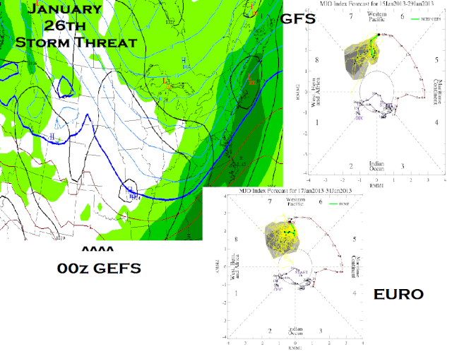
Very encouraging to see the latest MJO plots being taken into phase 8 by both the GFS/EURO. Even the GEFS are polar opposite of the GFS operational, which the NWS is foolishly siding with in the long range. Here are the 00z GEFS mean for the 26th storm, and the 23rd storm still needs to be watched as well for early next week. I like where things are heading.
Frank_Wx- Godzilla Seeker
- Posts : 21305
Reputation : 328
Join date : 2013-01-05
Age : 31
Location : Jersey City, NJ -
Re: January 2013 Long Range Thread
![]() by Frank_Wx Fri Jan 18, 2013 1:50 am
by Frank_Wx Fri Jan 18, 2013 1:50 am

Frank_Wx- Godzilla Seeker
- Posts : 21305
Reputation : 328
Join date : 2013-01-05
Age : 31
Location : Jersey City, NJ -
Re: January 2013 Long Range Thread
![]() by sroc4 Fri Jan 18, 2013 7:35 am
by sroc4 Fri Jan 18, 2013 7:35 am
The predicted PNA has been the most consistent amongst the models, perfect position.
https://2img.net/r/ihimizer/img842/9217/12zallpnajan22.gif
The + NAO the GFS shows is the outlier at this time.
https://2img.net/r/ihimizer/img13/3659/12zallnaojan22.gif
-AO would indicate that if a surface low were to phase along the coast it would have plenty of cold air to work with.
https://2img.net/r/ihimizer/img23/9897/12zallaojan22.gif
The only thing I dont like about this potential is that the NAO will go from a pos state to a neutral or neg state which after reading the study on some of the historical storms that Ryan (Noreaster) posted in the Q and A thread is usually not the best scenario for a big storm to occur along the coast. However, that being said the Presidents day storm of Feb 2003 did have that NAO set up. According to that study a neg NAO rising towards neutral or even pos has historically produced the most major coastal storms.
Anyway I still think this thing will trend west over the next several days as the pieces of the puzzle begin to make there way onto the west coast and the models have more data to work with. Enough west to impact the coast is yet to be seen.
The weather will be what it wants to be...I just hope it be snowing.

sroc4- Admin
- Posts : 8331
Reputation : 301
Join date : 2013-01-07
Location : Wading River, LI
Re: January 2013 Long Range Thread
![]() by Frank_Wx Fri Jan 18, 2013 11:47 am
by Frank_Wx Fri Jan 18, 2013 11:47 am
Don't say I didn't warn ya!
MJO going into phase 8. L
Boooyahh!
Frank_Wx- Godzilla Seeker
- Posts : 21305
Reputation : 328
Join date : 2013-01-05
Age : 31
Location : Jersey City, NJ -
Re: January 2013 Long Range Thread
![]() by skinsfan1177 Fri Jan 18, 2013 12:49 pm
by skinsfan1177 Fri Jan 18, 2013 12:49 pm


skinsfan1177- Senior Enthusiast

- Posts : 4485
Reputation : 35
Join date : 2013-01-07
Age : 46
Location : Point Pleasant Boro
Re: January 2013 Long Range Thread
![]() by Frank_Wx Fri Jan 18, 2013 1:06 pm
by Frank_Wx Fri Jan 18, 2013 1:06 pm
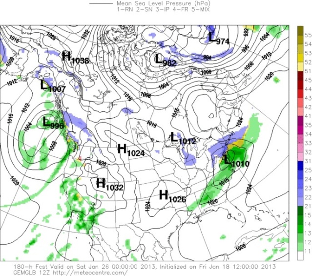
GGEM for 26th storm. It didn't have anything for the 23rd storm.
Frank_Wx- Godzilla Seeker
- Posts : 21305
Reputation : 328
Join date : 2013-01-05
Age : 31
Location : Jersey City, NJ -
Re: January 2013 Long Range Thread
![]() by NjWeatherGuy Fri Jan 18, 2013 2:40 pm
by NjWeatherGuy Fri Jan 18, 2013 2:40 pm

NjWeatherGuy- Advanced Forecaster

- Posts : 4100
Reputation : 28
Join date : 2013-01-06
Location : Belle Mead, NJ
Re: January 2013 Banter Thread
![]() by docstox12 Fri Jan 18, 2013 3:14 pm
by docstox12 Fri Jan 18, 2013 3:14 pm
NjWeatherGuy wrote:I just cant get excited about this until we get into the 4-5 day range. The GFS and NAM were different by several hundred miles for the last storm less than 48 hours to the event. These models are useless, I'm done with the long range and getting hyped up for something that will end up radically different.
Remember on the Channel 7 Board Bill Evans would say "Models are for guidance purposes only".Truer words were never spoken.yes, it's interesting to see what the computers spit out long range, but I never get really excited until a few hours before a projected snowstorm hits and I see the radar is totally filled without a dry slot and many hours of snow seen ahead on the said radar.
docstox12- Wx Statistician Guru
- Posts : 8507
Reputation : 222
Join date : 2013-01-07
Age : 73
Location : Monroe NY
Re: January 2013 Long Range Thread
![]() by Frank_Wx Fri Jan 18, 2013 4:42 pm
by Frank_Wx Fri Jan 18, 2013 4:42 pm
Frank_Wx- Godzilla Seeker
- Posts : 21305
Reputation : 328
Join date : 2013-01-05
Age : 31
Location : Jersey City, NJ -
Re: January 2013 Long Range Thread
![]() by NjWeatherGuy Fri Jan 18, 2013 5:26 pm
by NjWeatherGuy Fri Jan 18, 2013 5:26 pm
NjWeatherGuy- Advanced Forecaster
- Posts : 4100
Reputation : 28
Join date : 2013-01-06
Location : Belle Mead, NJ
Re: January 2013 Long Range Thread
![]() by Frank_Wx Fri Jan 18, 2013 11:41 pm
by Frank_Wx Fri Jan 18, 2013 11:41 pm
Frank_Wx- Godzilla Seeker
- Posts : 21305
Reputation : 328
Join date : 2013-01-05
Age : 31
Location : Jersey City, NJ -
Re: January 2013 Banter Thread
![]() by docstox12 Sat Jan 19, 2013 5:50 am
by docstox12 Sat Jan 19, 2013 5:50 am
Frank_Wx wrote:GFS has the snowstorm for end of next week. About a foot of snow this run. I'll take it. Lol
Impressive and interesting.NWS was starting to mention something but they had rain/snow for NNJ on Friday I think.Way too far out to tell, but the models see something.I'll get excited next Thursday,LOL!
docstox12- Wx Statistician Guru
- Posts : 8507
Reputation : 222
Join date : 2013-01-07
Age : 73
Location : Monroe NY
Re: January 2013 Long Range Thread
![]() by Frank_Wx Sat Jan 19, 2013 10:29 am
by Frank_Wx Sat Jan 19, 2013 10:29 am
I'll be working today. Will get a blog up tonight or tomorrow.
Frank_Wx- Godzilla Seeker
- Posts : 21305
Reputation : 328
Join date : 2013-01-05
Age : 31
Location : Jersey City, NJ -

Frank_Wx- Godzilla Seeker
- Posts : 21305
Reputation : 328
Join date : 2013-01-05
Age : 31
Location : Jersey City, NJ -
Re: January 2013 Long Range Thread
![]() by Frank_Wx Tue Jan 22, 2013 2:41 pm
by Frank_Wx Tue Jan 22, 2013 2:41 pm

Frank_Wx- Godzilla Seeker
- Posts : 21305
Reputation : 328
Join date : 2013-01-05
Age : 31
Location : Jersey City, NJ -
Re: January 2013 Long Range Thread
![]() by Noreaster Tue Jan 22, 2013 11:41 pm
by Noreaster Tue Jan 22, 2013 11:41 pm

Noreaster- Posts : 463
Reputation : 5
Join date : 2013-01-08
Age : 41
Location : Merrick, NY
Re: January 2013 Long Range Thread
![]() by Frank_Wx Fri Jan 25, 2013 12:45 am
by Frank_Wx Fri Jan 25, 2013 12:45 am
Seriously, it's so hard to resist looking at models when you're desperate for snow.

Frank_Wx- Godzilla Seeker
- Posts : 21305
Reputation : 328
Join date : 2013-01-05
Age : 31
Location : Jersey City, NJ -
Re: January 2013 Long Range Thread
![]() by Snow88 Fri Jan 25, 2013 8:18 am
by Snow88 Fri Jan 25, 2013 8:18 am

Snow88- Senior Enthusiast
- Posts : 2193
Reputation : 4
Join date : 2013-01-09
Age : 35
Location : Brooklyn, NY


Snow88- Senior Enthusiast
- Posts : 2193
Reputation : 4
Join date : 2013-01-09
Age : 35
Location : Brooklyn, NY
Re: January 2013 Long Range Thread
![]() by Frank_Wx Fri Jan 25, 2013 10:49 am
by Frank_Wx Fri Jan 25, 2013 10:49 am
I'll be away most of the day. Hopefully by Monday, we'll have a storm to track for the end of next week.
Frank_Wx- Godzilla Seeker
- Posts : 21305
Reputation : 328
Join date : 2013-01-05
Age : 31
Location : Jersey City, NJ -
Re: January 2013 Long Range Thread
![]() by Math23x7 Fri Jan 25, 2013 11:49 am
by Math23x7 Fri Jan 25, 2013 11:49 am
Math23x7- Wx Statistician Guru
- Posts : 2379
Reputation : 68
Join date : 2013-01-08
Re: January 2013 Long Range Thread
![]() by amugs Fri Jan 25, 2013 11:03 pm
by amugs Fri Jan 25, 2013 11:03 pm

amugs- Advanced Forecaster - Mod

- Posts : 15093
Reputation : 213
Join date : 2013-01-07
Age : 54
Location : Hillsdale,NJ
Page 4 of 5 • 1, 2, 3, 4, 5 ![]()
|
|
|