
 Search
January 2013 Long Range Thread
Page 2 of 5 •  1, 2, 3, 4, 5
 ![]()
Re: January 2013 Long Range Thread
![]() by aiannone Tue Jan 08, 2013 3:53 pm
by aiannone Tue Jan 08, 2013 3:53 pm
THE SECOND PATTERN CHANGE WILL BEGIN TO SHOW ITS CARDS BY THE MIDDLE
OF THE MONTH. A MAJOR SUDDEN STRATOSPHERIC WARMING EVENT IS UNDERWAY
AND NEARING COMPLETION. SUDDEN STRATOSPHERIC WARMING EVENTS ARE
FAVORED TO OCCUR DURING AN EASTERLY PHASE OF THE QUASI-BIENNIAL
OSCILLATION /QBO/…WHICH IS THE PHASE THE STRATOSPHERE IS IN THIS
WINTER. THE SUDDEN STRATOSPHERIC WARMING CAUSES A DRAMATIC
WEAKENING…AND SOMETIMES ENTIRE BREAKDOWN OF THE STRATOSPHERIC
POLAR VORTEX…AND A GREAT WEAKENING OR EVEN REVERSAL OF THE
STRATOSPHERIC POLAR NIGHT JET. THE GFS FORECASTS THIS TO OCCUR OVER
THE NEXT WEEK AT THE 2MB LEVEL.
THE RESULT OF ALL OF THIS IS THE GENERATION OF STRONG HIGH LATITUDE
BLOCKING AS THE DRAMATIC CHANGES IN THE STRATOSPHERE FEED DOWN INTO
THE TROPOSPHERE. HIGH LATITUDE BLOCKING FORCES THE COLDEST AIR SOUTH
OUT OF THE HIGH ARCTIC AND TOWARDS THE MID LATITUDES…AND ALSO
FAVORS LASTING STRONGLY NEGATIVE EPISODES OF ARCTIC OSCILLATION /AO/
AND NORTH ATLANTIC OSCILLATION /NAO/. THIS TYPICALLY BEGINS TO TAKE
PLACE 10-15 DAYS AFTER THE SUDDEN STRATOSPHERIC WARMING EVENT. HOW
LONG IT LASTS CAN VARY…BUT TYPICALLY THE COLD PATTERN LASTS FOR AT
LEAST A FEW WEEKS…AND OCCASIONALLY CAN PERSIST THROUGH THE REST OF
WINTER.
AS ALL OF THIS IS OCCURRING…THE MJO IS FORECAST BY THE GEFS
ENSEMBLES TO WEAKEN AND FADE AWAY IN ABOUT 10 DAYS. THE PACIFIC
NORTH AMERICAN PATTERN /PNA/ IS FORECAST TO REMAIN NEGATIVE OVER THE
NEXT 10 DAYS…WHICH WILL DIRECT THE FIRST BATCHES OF COLD INTO THE
WESTERN AND EVENTUALLY CENTRAL UNITED STATES. GEFS ENSEMBLE MEMBERS
SUPPORT A TREND TOWARDS A NEUTRAL OR POSITIVE PNA BY THE MIDDLE OF
THE MONTH…WHICH SHOULD ALLOW THE GROWING COLD TO SPREAD EASTWARD.
WHAT ALL OF THIS TECHNICAL JARGON MEANS IS THAT THERE IS MODERATE TO
HIGH CONFIDENCE IN A PATTERN CHANGE TOWARDS MUCH COLDER WEATHER FOR
THE CENTRAL AND EASTERN UNITED STATES STARTING AROUND THE MIDDLE OF
JANUARY…WITH COLD LIKELY PEAKING IN LATE JANUARY INTO EARLY
FEBRUARY. THERE IS THE POTENTIAL FOR THE COLDEST AIR WE HAVE SEEN IN
AT LEAST SEVERAL YEARS DURING THIS PERIOD. WHAT SNOW POTENTIAL THIS
WILL BRING IS MUCH MORE UNCERTAIN DUE TO UNKNOWN DETAILS WITH
SYNOPTIC STORM TRACK AND LAKE EFFECT POTENTIAL.
aiannone- Senior Enthusiast - Mod

- Posts : 4814
Join date : 2013-01-07
Re: January 2013 Long Range Thread
![]() by NjWeatherGuy Tue Jan 08, 2013 7:30 pm
by NjWeatherGuy Tue Jan 08, 2013 7:30 pm
From what i've seen before the pattern change arrives a very slow moving cold front will move over the region. To me it looked pretty strong so I checked the GFS and today's 18z run at hour 192 shows elevated CAPE, lifting and showalter indeces over our area. Nothing too extreme but I think we cant rule out some rumbles of thunder or lightning as this passes through. Of course, it's too far away at this time to know what will happen exactly.
NjWeatherGuy- Advanced Forecaster

- Posts : 4100
Join date : 2013-01-06
Re: January 2013 Long Range Thread
![]() by NjWeatherGuy Tue Jan 08, 2013 7:44 pm
by NjWeatherGuy Tue Jan 08, 2013 7:44 pm

NjWeatherGuy- Advanced Forecaster
- Posts : 4100
Reputation : 28
Join date : 2013-01-06
Location : Belle Mead, NJ
Re: January 2013 Long Range Thread
![]() by Frank_Wx Wed Jan 09, 2013 7:02 pm
by Frank_Wx Wed Jan 09, 2013 7:02 pm

Frank_Wx- Godzilla Seeker

- Posts : 21305
Reputation : 328
Join date : 2013-01-05
Age : 31
Location : Jersey City, NJ -

Re: January 2013 Long Range Thread
![]() by Frank_Wx Wed Jan 09, 2013 7:04 pm
by Frank_Wx Wed Jan 09, 2013 7:04 pm
Also, did anyone notice the UKMET MJO? It gets into phase 7, unlike some models showing once the MJO gets into phase 6 it dies
Frank_Wx- Godzilla Seeker
- Posts : 21305
Reputation : 328
Join date : 2013-01-05
Age : 31
Location : Jersey City, NJ -
Re: January 2013 Long Range Thread
![]() by amugs Wed Jan 09, 2013 7:41 pm
by amugs Wed Jan 09, 2013 7:41 pm

amugs- Advanced Forecaster - Mod
- Posts : 15093
Reputation : 213
Join date : 2013-01-07
Age : 54
Location : Hillsdale,NJ
Re: January 2013 Long Range Thread
![]() by Frank_Wx Wed Jan 09, 2013 8:12 pm
by Frank_Wx Wed Jan 09, 2013 8:12 pm
amugs wrote:Seems to be good news! Any word Frank on why I cannot post an external link or has this issue been cleared up?
I thought I fixed this problem. Let me try again.
Frank_Wx- Godzilla Seeker
- Posts : 21305
Reputation : 328
Join date : 2013-01-05
Age : 31
Location : Jersey City, NJ -
Re: January 2013 Long Range Thread
![]() by amugs Wed Jan 09, 2013 9:43 pm
by amugs Wed Jan 09, 2013 9:43 pm
Here is the update from Accuweather and they are reflecting what you guys are saying that the cold air will be here but only last a few days and then warm up and this back and forth for the last weeks of Jan into early Feb due to this stubborn SE ridge/ High Pressure off the Southeastern US/Atlantic.
Question - what can move or breakdown this sort of cold air blocking mechanism? Just trying to learn.
amugs- Advanced Forecaster - Mod
- Posts : 15093
Reputation : 213
Join date : 2013-01-07
Age : 54
Location : Hillsdale,NJ
Re: January 2013 Long Range Thread
![]() by amugs Wed Jan 09, 2013 9:44 pm
by amugs Wed Jan 09, 2013 9:44 pm
amugs- Advanced Forecaster - Mod
- Posts : 15093
Reputation : 213
Join date : 2013-01-07
Age : 54
Location : Hillsdale,NJ
Re: January 2013 Long Range Thread
![]() by Noreaster Wed Jan 09, 2013 9:56 pm
by Noreaster Wed Jan 09, 2013 9:56 pm

Noreaster- Posts : 463
Reputation : 5
Join date : 2013-01-08
Age : 41
Location : Merrick, NY
Re: January 2013 Long Range Thread
![]() by Frank_Wx Wed Jan 09, 2013 10:02 pm
by Frank_Wx Wed Jan 09, 2013 10:02 pm
amugs wrote:http://www.accuweather.com/en/weather-news/timing-the-arctic-cold/3777976
Here is the update from Accuweather and they are reflecting what you guys are saying that the cold air will be here but only last a few days and then warm up and this back and forth for the last weeks of Jan into early Feb due to this stubborn SE ridge/ High Pressure off the Southeastern US/Atlantic.
Question - what can move or breakdown this sort of cold air blocking mechanism? Just trying to learn.
That's the big question going forward. I'm going to have to disagree with Accuweather here.
I think the active MJO cycle will be enough to push the southeast ridge further east and out to sea. Once the PV situates itself over south-central Canada, a trough will build in over the east and supply cold air. I don't think it will be arctic air, but definitely cold.
The -NAO signal over Greenland should be enough to maintain the PV and prevent it from moving, thus preventing the southeast ridge from returning.
Frank_Wx- Godzilla Seeker
- Posts : 21305
Reputation : 328
Join date : 2013-01-05
Age : 31
Location : Jersey City, NJ -
Re: January 2013 Long Range Thread
![]() by NjWeatherGuy Thu Jan 10, 2013 3:07 pm
by NjWeatherGuy Thu Jan 10, 2013 3:07 pm
NjWeatherGuy- Advanced Forecaster
- Posts : 4100
Reputation : 28
Join date : 2013-01-06
Location : Belle Mead, NJ
Re: January 2013 Long Range Thread
![]() by Frank_Wx Fri Jan 11, 2013 11:21 am
by Frank_Wx Fri Jan 11, 2013 11:21 am

LOVE the look of the MJO today. Once it gets into phase 7, it looks to want to stay and loop around in there. I highly doubt it reverses back into phase 6 as some guidance showed yesterday.
Frank_Wx- Godzilla Seeker
- Posts : 21305
Reputation : 328
Join date : 2013-01-05
Age : 31
Location : Jersey City, NJ -
Re: January 2013 Long Range Thread
![]() by Frank_Wx Fri Jan 11, 2013 11:37 am
by Frank_Wx Fri Jan 11, 2013 11:37 am

Frank_Wx- Godzilla Seeker
- Posts : 21305
Reputation : 328
Join date : 2013-01-05
Age : 31
Location : Jersey City, NJ -
Re: January 2013 Long Range Thread
![]() by Frank_Wx Fri Jan 11, 2013 11:38 am
by Frank_Wx Fri Jan 11, 2013 11:38 am
Frank_Wx- Godzilla Seeker
- Posts : 21305
Reputation : 328
Join date : 2013-01-05
Age : 31
Location : Jersey City, NJ -
Re: January 2013 Long Range Thread
![]() by Frank_Wx Fri Jan 11, 2013 11:42 am
by Frank_Wx Fri Jan 11, 2013 11:42 am
Frank_Wx- Godzilla Seeker
- Posts : 21305
Reputation : 328
Join date : 2013-01-05
Age : 31
Location : Jersey City, NJ -
Re: January 2013 Long Range Thread
![]() by Quietace Fri Jan 11, 2013 11:45 am
by Quietace Fri Jan 11, 2013 11:45 am

Quietace- Meteorologist - Mod

- Posts : 3687
Reputation : 33
Join date : 2013-01-07
Age : 27
Location : Point Pleasant, NJ
Re: January 2013 Long Range Thread
![]() by Frank_Wx Fri Jan 11, 2013 11:47 am
by Frank_Wx Fri Jan 11, 2013 11:47 am
Frank_Wx- Godzilla Seeker
- Posts : 21305
Reputation : 328
Join date : 2013-01-05
Age : 31
Location : Jersey City, NJ -
Re: January 2013 Long Range Thread
![]() by ltthedog Fri Jan 11, 2013 1:14 pm
by ltthedog Fri Jan 11, 2013 1:14 pm
ltthedog- Posts : 3
Reputation : 0
Join date : 2013-01-10
Re: January 2013 Long Range Thread
![]() by Frank_Wx Fri Jan 11, 2013 1:44 pm
by Frank_Wx Fri Jan 11, 2013 1:44 pm
ltthedog wrote:Frank your thoughts on the midweek storm potential. 12Z GFS basically lost it but GGEM, and the CFS still have a major overruning event while with marginal temps certainly looks like a lot of precip may fall looking at these models verbatim.
We're talking about it in the other thread.
Frank_Wx- Godzilla Seeker
- Posts : 21305
Reputation : 328
Join date : 2013-01-05
Age : 31
Location : Jersey City, NJ -
Re: January 2013 Long Range Thread
![]() by Dunnzoo Fri Jan 11, 2013 4:09 pm
by Dunnzoo Fri Jan 11, 2013 4:09 pm

Dunnzoo- Senior Enthusiast - Mod
- Posts : 4892
Reputation : 68
Join date : 2013-01-11
Age : 62
Location : Westwood, NJ
Re: January 2013 Long Range Thread
![]() by Frank_Wx Fri Jan 11, 2013 11:32 pm
by Frank_Wx Fri Jan 11, 2013 11:32 pm
Frank_Wx- Godzilla Seeker
- Posts : 21305
Reputation : 328
Join date : 2013-01-05
Age : 31
Location : Jersey City, NJ -

Frank_Wx- Godzilla Seeker
- Posts : 21305
Reputation : 328
Join date : 2013-01-05
Age : 31
Location : Jersey City, NJ -
Frank_Wx- Godzilla Seeker
- Posts : 21305
Reputation : 328
Join date : 2013-01-05
Age : 31
Location : Jersey City, NJ -
Re: January 2013 Long Range Thread
![]() by Frank_Wx Sat Jan 12, 2013 2:00 am
by Frank_Wx Sat Jan 12, 2013 2:00 am

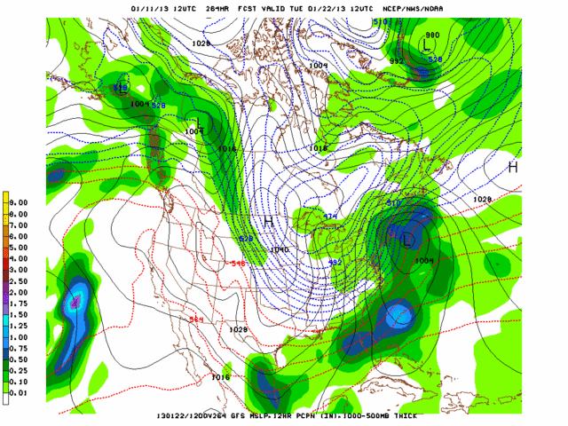
If one were to extrapolate the 00z EURO beyond 240, I think it would have shown some sort of east coast storm around the 23rd. The PV split, allowing for relaxation in the pattern, and there is a nice nagative tilt in our trough coupled with a +PNA/-EPO/-NAO
Honestly, if the upcoming pattern does not produce something between the 20th-25th, I'll be shocked.
Frank_Wx- Godzilla Seeker
- Posts : 21305
Reputation : 328
Join date : 2013-01-05
Age : 31
Location : Jersey City, NJ -
Re: January 2013 Long Range Thread
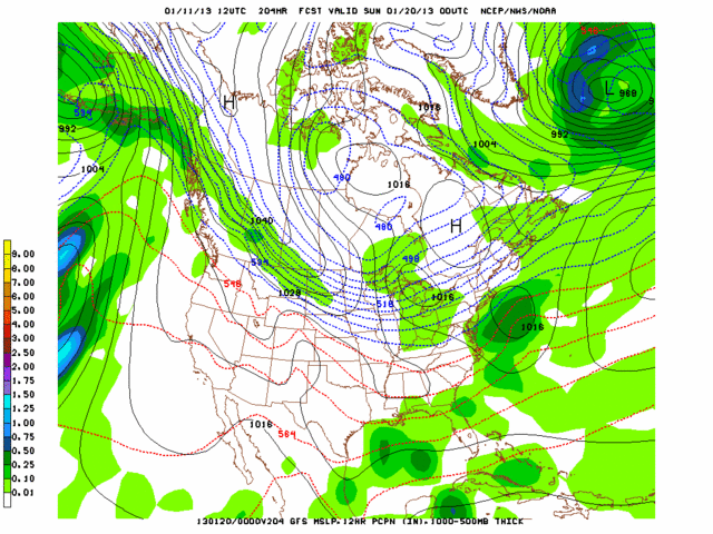
![]() by Frank_Wx Sat Jan 12, 2013 1:04 pm
by Frank_Wx Sat Jan 12, 2013 1:04 pm
Incredible blocking
Great ridging
MJO progression through 7
Storm signals between 20th-26th.
Sometime in that time period, there will be a storm.
Frank_Wx- Godzilla Seeker
- Posts : 21305
Reputation : 328
Join date : 2013-01-05
Age : 31
Location : Jersey City, NJ -
Re: January 2013 Long Range Thread
![]() by Frank_Wx Sat Jan 12, 2013 3:36 pm
by Frank_Wx Sat Jan 12, 2013 3:36 pm

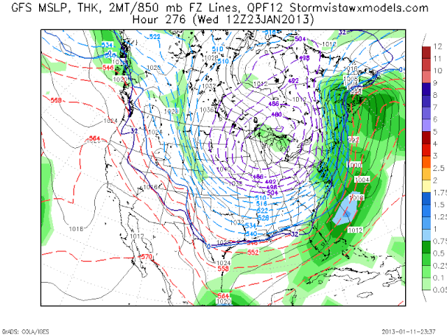
Euro is showing 850mb temps sub -20C in the long range. Downright frigid!!!!
Frank_Wx- Godzilla Seeker
- Posts : 21305
Reputation : 328
Join date : 2013-01-05
Age : 31
Location : Jersey City, NJ -
Page 2 of 5 • 1, 2, 3, 4, 5 ![]()
|
|
|