
 Search
March 14, 2017 Storm In Review
Page 2 of 3 •  1, 2, 3
 ![]()
Re: March 14, 2017 Storm In Review
![]() by Dtone Wed Mar 15, 2017 11:38 am
by Dtone Wed Mar 15, 2017 11:38 am
devsman wrote:Just got to work in Flushing Queens. These roads are the worst of seen here in any storm. I had to park half mile away from my school. Every car is trapped in ice. Deblasio did a horrible job. Cars are stranded in the street. Bad bad job NYC.
Yeah it is bad. To be fair I think its more the nature of sleet compared to snow then anything the city could of done.
Just b/c there wasn't epic snow totals closer to the coast doesn't mean it wasn't a impactful storm. I would of had a easier time with 2 feet of pure snow than a foot of sleet. It sucks.
I have co workers from LI and they were shocked at the acclumations once they crossed the Whitestone.
Dtone- Wx Statistician Guru

- Posts : 1738
Join date : 2013-08-26
Re: March 14, 2017 Storm In Review
![]() by Frank_Wx Wed Mar 15, 2017 11:51 am
by Frank_Wx Wed Mar 15, 2017 11:51 am
billg315 wrote:I posted a story in banter, because I think its a better place for the discussion. But I would love to get people's thoughts/reactions because I found it stunning. The story I posted in Banter is an A.P. story where the NWS acknowledges thinking their prediction was overdone Monday afternoon, but not adjusting the totals downward because they wanted people to be prepared anyway. It's the first time I remember the NWS admitting they left a forecast out there they didn't really believe in, to achieve a "preparedness" goal. I submit, (and I really do respect these guys and the tough work they do) that for their credibility alone, as well as scientific honesty, this was a mistake.
Agree it was a mistake. The purpose of an accurate forecast is to gain the trust of the general public. When the next storm comes around, maybe less people will take their forecast seriously. Don't these guys have a way to measure their performance? If, say, at the end of the year you have an 85% accuracy but your goal is 90%, then you're hurting yourself personally too. I just do not understand that logic.
Frank_Wx- Godzilla Seeker

- Posts : 21305
Join date : 2013-01-05 -

Re: March 14, 2017 Storm In Review
![]() by aiannone Wed Mar 15, 2017 12:54 pm
by aiannone Wed Mar 15, 2017 12:54 pm
_________________
-Alex Iannone-

aiannone- Senior Enthusiast - Mod

- Posts : 4813
Reputation : 92
Join date : 2013-01-07
Location : Saint James, LI (Northwest Suffolk Co.)
Re: March 14, 2017 Storm In Review
![]() by CPcantmeasuresnow Wed Mar 15, 2017 12:58 pm
by CPcantmeasuresnow Wed Mar 15, 2017 12:58 pm
aiannone wrote:34.2" here just west of Binghamton, NY. Incredible. Snowiest storm on record here and we are 3.7" away from the snowiest winter on record!
What's the total there for the winter so far. I know they average in the 80's for the season so to be near a record you must be well past 100?

CPcantmeasuresnow- Wx Statistician Guru
- Posts : 7274
Reputation : 230
Join date : 2013-01-07
Age : 103
Location : Eastern Orange County, NY
Re: March 14, 2017 Storm In Review
![]() by dad4twoboys Wed Mar 15, 2017 1:05 pm
by dad4twoboys Wed Mar 15, 2017 1:05 pm
Click Me !!!
With a "shout out" to Alex in Binghampton !!!
dad4twoboys- Pro Enthusiast

- Posts : 200
Reputation : 12
Join date : 2013-01-08
Location : Brewster, New York -
Re: March 14, 2017 Storm In Review
![]() by Frank_Wx Wed Mar 15, 2017 1:32 pm
by Frank_Wx Wed Mar 15, 2017 1:32 pm

_________________
_______________________________________________________________________________________________________
CLICK HERE to view NJ Strong Snowstorm Classifications

Frank_Wx- Godzilla Seeker
- Posts : 21305
Reputation : 328
Join date : 2013-01-05
Age : 31
Location : Jersey City, NJ -
Re: March 14, 2017 Storm In Review
![]() by aiannone Wed Mar 15, 2017 1:36 pm
by aiannone Wed Mar 15, 2017 1:36 pm
CPcantmeasuresnow wrote:aiannone wrote:34.2" here just west of Binghamton, NY. Incredible. Snowiest storm on record here and we are 3.7" away from the snowiest winter on record!
What's the total there for the winter so far. I know they average in the 80's for the season so to be near a record you must be well past 100?
127.7". Record for snowiest winter is 131.3" set in 1993-1994
_________________
-Alex Iannone-
aiannone- Senior Enthusiast - Mod
- Posts : 4813
Reputation : 92
Join date : 2013-01-07
Location : Saint James, LI (Northwest Suffolk Co.)
Re: March 14, 2017 Storm In Review
![]() by CPcantmeasuresnow Wed Mar 15, 2017 1:40 pm
by CPcantmeasuresnow Wed Mar 15, 2017 1:40 pm
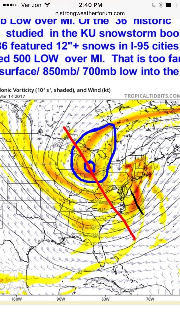
Frank_Wx wrote:This graphic is kinda telling
Amazing so many missed this, models included. Except of course that POS the NAM, which it seems has done pretty well out on it's own early over the past couple of years.
I keep thinking of the poor gullible person in Red Sox Suck that may have looked at the HRRR the day before and saw the 44 inches over their house who might have believed it, then to end up with 6 inches, wow talk about a let down.
CPcantmeasuresnow- Wx Statistician Guru
- Posts : 7274
Reputation : 230
Join date : 2013-01-07
Age : 103
Location : Eastern Orange County, NY
Re: March 14, 2017 Storm In Review
![]() by CPcantmeasuresnow Wed Mar 15, 2017 1:41 pm
by CPcantmeasuresnow Wed Mar 15, 2017 1:41 pm
aiannone wrote:CPcantmeasuresnow wrote:aiannone wrote:34.2" here just west of Binghamton, NY. Incredible. Snowiest storm on record here and we are 3.7" away from the snowiest winter on record!
What's the total there for the winter so far. I know they average in the 80's for the season so to be near a record you must be well past 100?
127.7". Record for snowiest winter is 131.3" set in 1993-1994
I don't want to jinx it and say that looks like a lock, so I won't.
CPcantmeasuresnow- Wx Statistician Guru
- Posts : 7274
Reputation : 230
Join date : 2013-01-07
Age : 103
Location : Eastern Orange County, NY
Re: March 14, 2017 Storm In Review
![]() by amugs Wed Mar 15, 2017 1:45 pm
by amugs Wed Mar 15, 2017 1:45 pm
_________________
Mugs
AKA:King: Snow Weenie
Self Proclaimed
WINTER 2014-15 : 55.12" +.02 for 6 coatings (avg. 35")
WINTER 2015-16 Total - 29.8" (Avg 35")
WINTER 2016-17 : 39.5" so far

amugs- Advanced Forecaster - Mod
- Posts : 15093
Reputation : 213
Join date : 2013-01-07
Age : 54
Location : Hillsdale,NJ
Re: March 14, 2017 Storm In Review
![]() by nutleyblizzard Wed Mar 15, 2017 2:06 pm
by nutleyblizzard Wed Mar 15, 2017 2:06 pm

nutleyblizzard- Senior Enthusiast

- Posts : 1952
Reputation : 41
Join date : 2014-01-30
Age : 58
Location : Nutley, new jersey
Re: March 14, 2017 Storm In Review
![]() by Guest Wed Mar 15, 2017 2:15 pm
by Guest Wed Mar 15, 2017 2:15 pm
Frank_Wx wrote:This graphic is kinda telling
Not to pat myself on the back because I don't have the scientific knowledge that you guys do BUT.....Leading up to the storm I actually posted in response to one of Amugs's posts that we don't want the upper low diving in to be too strong because it would pull the LP too close to the coast and therefore create a warm solution.
Guest- Guest
Re: March 14, 2017 Storm In Review
![]() by Scullybutcher Wed Mar 15, 2017 2:23 pm
by Scullybutcher Wed Mar 15, 2017 2:23 pm
nutleyblizzard wrote:Commenting from an earlier post Sroc made, if we had a -NAO, not only would the storm of been a slower mover, but the polar jet would have had ample time to catch up with the other streams. I know this is throwing salt in the wound who missed out with the brunt of the storm (myself included), but think about it. A slow moving colder version triple phased bomb. I can imagine a snow map of 18-24 inches in DC, climbing to 2-3 feet in philly/south Jersey, 3 feet+ north Jersey/ NYC/LI, 4 feet+ New England.
I hope I get to see this storm in my lifetime.

Scullybutcher- Pro Enthusiast
- Posts : 543
Reputation : 16
Join date : 2013-02-06
Location : North Smithtown, western Suffolk county, long island
Re: March 14, 2017 Storm In Review
![]() by nutleyblizzard Wed Mar 15, 2017 2:38 pm
by nutleyblizzard Wed Mar 15, 2017 2:38 pm
That's my dream storm. We were just missing the one key ingredient- blocking. Ive got a feeling one day hopefully soon we will.Scullybutcher wrote:nutleyblizzard wrote:Commenting from an earlier post Sroc made, if we had a -NAO, not only would the storm of been a slower mover, but the polar jet would have had ample time to catch up with the other streams. I know this is throwing salt in the wound who missed out with the brunt of the storm (myself included), but think about it. A slow moving colder version triple phased bomb. I can imagine a snow map of 18-24 inches in DC, climbing to 2-3 feet in philly/south Jersey, 3 feet+ north Jersey/ NYC/LI, 4 feet+ New England.
I hope I get to see this storm in my lifetime.
nutleyblizzard- Senior Enthusiast
- Posts : 1952
Reputation : 41
Join date : 2014-01-30
Age : 58
Location : Nutley, new jersey
Re: March 14, 2017 Storm In Review
![]() by sroc4 Wed Mar 15, 2017 2:40 pm
by sroc4 Wed Mar 15, 2017 2:40 pm
Frank_Wx wrote:This graphic is kinda telling
I'm not sure I agree with the drawn in lines of this graphic. I can understand the concept but this is not a defined closed low. I think it is a matter of the northern piece not in sink with the PAC and ST piece. That's just my opinion. The red line is depicting what? The fully phased trough? Again I don't believe that.
_________________
"In weather and in life, there's no winning and losing; there's only winning and learning."
WINTER 2012/2013 TOTALS 43.65"WINTER 2017/2018 TOTALS 62.85" WINTER 2022/2023 TOTALS 4.9"
WINTER 2013/2014 TOTALS 64.85"WINTER 2018/2019 TOTALS 14.25" WINTER 2023/2024 TOTALS 13.1"
WINTER 2014/2015 TOTALS 71.20"WINTER 2019/2020 TOTALS 6.35"
WINTER 2015/2016 TOTALS 35.00"WINTER 2020/2021 TOTALS 37.75"
WINTER 2016/2017 TOTALS 42.25"WINTER 2021/2022 TOTALS 31.65"

sroc4- Admin
- Posts : 8331
Reputation : 301
Join date : 2013-01-07
Location : Wading River, LI
Re: March 14, 2017 Storm In Review
![]() by sroc4 Wed Mar 15, 2017 2:42 pm
by sroc4 Wed Mar 15, 2017 2:42 pm
_________________
"In weather and in life, there's no winning and losing; there's only winning and learning."
WINTER 2012/2013 TOTALS 43.65"WINTER 2017/2018 TOTALS 62.85" WINTER 2022/2023 TOTALS 4.9"
WINTER 2013/2014 TOTALS 64.85"WINTER 2018/2019 TOTALS 14.25" WINTER 2023/2024 TOTALS 13.1"
WINTER 2014/2015 TOTALS 71.20"WINTER 2019/2020 TOTALS 6.35"
WINTER 2015/2016 TOTALS 35.00"WINTER 2020/2021 TOTALS 37.75"
WINTER 2016/2017 TOTALS 42.25"WINTER 2021/2022 TOTALS 31.65"
sroc4- Admin
- Posts : 8331
Reputation : 301
Join date : 2013-01-07
Location : Wading River, LI
Re: March 14, 2017 Storm In Review
![]() by amugs Wed Mar 15, 2017 3:16 pm
by amugs Wed Mar 15, 2017 3:16 pm
nutleyblizzard wrote:Commenting from an earlier post Sroc made, if we had a -NAO, not only would the storm of been a slower mover, but the polar jet would have had ample time to catch up with the other streams. I know this is throwing salt in the wound who missed out with the brunt of the storm (myself included), but think about it. A slow moving colder version triple phased bomb. I can imagine a snow map of 18-24 inches in DC, climbing to 2-3 feet in philly/south Jersey, 3 feet+ north Jersey/ NYC/LI, 4 feet+ New England.
The -NAO was teh key that models were showing even three days prior and it retrograded on us. The wave 2 was to be and was modeled as a 50/50 LP. Both of these did not come to fruition - IF we had one or the other (rather the 50/50 IMO) this woudl have been a longer duration event as you say Nuts. WE maybe able to pull one of these scenarios off in the upcoming decade. Heck look at teh all teh blizzard criteria storm the tri state area has been affected by since 2009? Seven - Dec 2009, Boxer Day 2010 (names non existent then), Jan 24-25(?) 2011, Nemo, Juno, Jonas and Stella. I thought 78 - 83 (77, 78 and 83)was a good stretch but this is one the best.
Anyway, I recieved 13.0" from the storm so i am not complaining - IF it did not go over to sleet I woudl have had 18-20" beggars cant be choosers!
_________________
Mugs
AKA:King: Snow Weenie
Self Proclaimed
WINTER 2014-15 : 55.12" +.02 for 6 coatings (avg. 35")
WINTER 2015-16 Total - 29.8" (Avg 35")
WINTER 2016-17 : 39.5" so far
amugs- Advanced Forecaster - Mod
- Posts : 15093
Reputation : 213
Join date : 2013-01-07
Age : 54
Location : Hillsdale,NJ
Re: March 14, 2017 Storm In Review
![]() by UnionWX Wed Mar 15, 2017 4:14 pm
by UnionWX Wed Mar 15, 2017 4:14 pm
20" here.

UnionWX- Posts : 31
Reputation : 0
Join date : 2015-10-05
Age : 38
Location : Hardyston Twp, NJ (NE Sussex)
Re: March 14, 2017 Storm In Review
![]() by CPcantmeasuresnow Wed Mar 15, 2017 5:21 pm
by CPcantmeasuresnow Wed Mar 15, 2017 5:21 pm

CPcantmeasuresnow- Wx Statistician Guru
- Posts : 7274
Reputation : 230
Join date : 2013-01-07
Age : 103
Location : Eastern Orange County, NY
Re: March 14, 2017 Storm In Review
![]() by weatherwatchermom Wed Mar 15, 2017 6:20 pm
by weatherwatchermom Wed Mar 15, 2017 6:20 pm
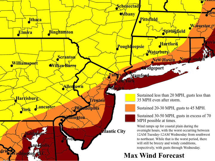
CPcantmeasuresnow wrote:Judging from this map, it looks like RB left his job in Fishkill where they had 26 inches to go home to NEPA where they had 26.5 inches. So I suppose he made the right decision? What the snowchoholic won't do for a 1/2 inch of snow. We're a sick bunch.


weatherwatchermom- Senior Enthusiast
- Posts : 3734
Reputation : 77
Join date : 2014-11-25
Age : 60
Location : Hazlet Township, NJ
Re: March 14, 2017 Storm In Review
![]() by frank 638 Wed Mar 15, 2017 7:00 pm
by frank 638 Wed Mar 15, 2017 7:00 pm
also i just want say thank u to sroc docstox jmanley and many more for all your hardwork you do .
frank 638- Senior Enthusiast
- Posts : 2824
Reputation : 37
Join date : 2016-01-01
Age : 40
Location : bronx ny
Re: March 14, 2017 Storm In Review
![]() by amugs Wed Mar 15, 2017 8:39 pm
by amugs Wed Mar 15, 2017 8:39 pm
Frank,
Awesome job. Was right along with u, Armondo amd others on this storm. Heck not the 1st time a stirm has thrown a last minute curve and it won't be the last. Many variables that can happen with these intense. Great job kid and onto the next one.
The afternoon chat was great and anytime we chat it is great and means a big storm.
We learn from Big Momma and always will.
Thanks for everyone input here and sharing of information.
_________________
Mugs
AKA:King: Snow Weenie
Self Proclaimed
WINTER 2014-15 : 55.12" +.02 for 6 coatings (avg. 35")
WINTER 2015-16 Total - 29.8" (Avg 35")
WINTER 2016-17 : 39.5" so far
amugs- Advanced Forecaster - Mod
- Posts : 15093
Reputation : 213
Join date : 2013-01-07
Age : 54
Location : Hillsdale,NJ
Re: March 14, 2017 Storm In Review
![]() by docstox12 Thu Mar 16, 2017 5:41 am
by docstox12 Thu Mar 16, 2017 5:41 am
CPcantmeasuresnow wrote:Judging from this map, it looks like RB left his job in Fishkill where they had 26 inches to go home to NEPA where they had 26.5 inches. So I suppose he made the right decision? What the snowchoholic won't do for a 1/2 inch of snow. We're a sick bunch.
Friggin' HILARIOUS.Coffee spit out worthy.

docstox12- Wx Statistician Guru
- Posts : 8502
Reputation : 222
Join date : 2013-01-07
Age : 73
Location : Monroe NY
Re: March 14, 2017 Storm In Review
![]() by oldtimer Thu Mar 16, 2017 11:01 am
by oldtimer Thu Mar 16, 2017 11:01 am
Last edited by oldtimer on Thu Mar 16, 2017 12:53 pm; edited 2 times in total (Reason for editing : want to add to Doc)
oldtimer- Senior Enthusiast
- Posts : 1103
Reputation : 14
Join date : 2013-01-16
Age : 78
Location : Port Jefferson Station Suffolk County
Re: March 14, 2017 Storm In Review
![]() by docstox12 Thu Mar 16, 2017 11:19 am
by docstox12 Thu Mar 16, 2017 11:19 am
oldtimer wrote:Hey I been thinking of you Doc and Cp Got a big kick out your excitement It been quite awhile for a big one Can you imagine if it was to kick 50 miles east The whole I95 would had 30 I still thing we will have couple more plowable systems
OK, Oldtimer, I'm with you.We might have one this weekend up here and it sure stays cold through next week.Might be another in the wings before the April showers hit.
docstox12- Wx Statistician Guru
- Posts : 8502
Reputation : 222
Join date : 2013-01-07
Age : 73
Location : Monroe NY
Re: March 14, 2017 Storm In Review
![]() by rb924119 Thu Mar 16, 2017 2:51 pm
by rb924119 Thu Mar 16, 2017 2:51 pm
To more important points, and mainly Frank, I would certainly not call this a "disappointing forecast". First off, you, myself, and the rest of our long range crew scoped this from YARD, with (I believe) Tom and Armando leading the way SEVERAL WEEKS in advance. Inside of ten days, that's when you, myself, Scott, Mugs, and Al(gae) started to add our opinions to the discussion as well. As far as I know, WE WERE THE ONLY ONES EVEN ALLUDING TO THE RETURN OF WINTER EVEN WITHIN SEVEN TO TEN DAYS BEFORE THE EVENT!!! That HAS to count for something. Just the ability to highlight a three or four day stretch and say "yup, we really like this period for a potential winter storm" from ten or more days out is remarkable, and I think it deserves to be recognized. Secondly, you went with a call that supported YOUR own reasoning. YOU picked a storm track, YOU picked the QPF (which, btw, you kicked my arse with, seeing as though widespread totals of 30"+ were achieved across the northern tier of PA and central NY, something I didn't think was going to be possible, so yet another hat tip to you). YOU DIDN'T let the models lead you blindly. As you always do, you had methods behind your madness; you weren't just blindly following, like I think many other forecasters were. Having reasons for what you forecast makes learning from them all the easier, because you can identify the pieces that didn't fall into place and keep those lessons stored for another storm, which you did, and is yet ANOTHER success. You think all of these TV mets who were fiercely defending why they got it wrong have done this same analysis? Not even close. Their hands have been washed and they've moved right along without breaking stride, because all they do is follow guidance. You managed to turn this into a learning experience for everybody, and there is NEVER a disappointment in learning. How many have you gotten right in your career (this season) compared to wrong? Yeah, that's what I thought
rb924119- Meteorologist

- Posts : 6889
Reputation : 194
Join date : 2013-02-06
Age : 32
Location : Greentown, Pa
Re: March 14, 2017 Storm In Review
![]() by rb924119 Thu Mar 16, 2017 3:02 pm
by rb924119 Thu Mar 16, 2017 3:02 pm
Ok, sorry everybody but I DO NOT have time for a video right now. However, here is my overdue First Call:
Start: 11pm tonight to 3am tomorrow, for most, a couple hours before and after sunrise across southern and central New England.
End: Tuesday afternoon to evening, depending on where you are (, early-afternoon coastal plain), late-afternoon eastern Pa/NY, evening rest of New England)
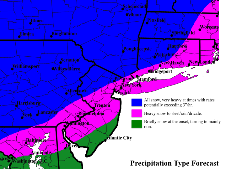
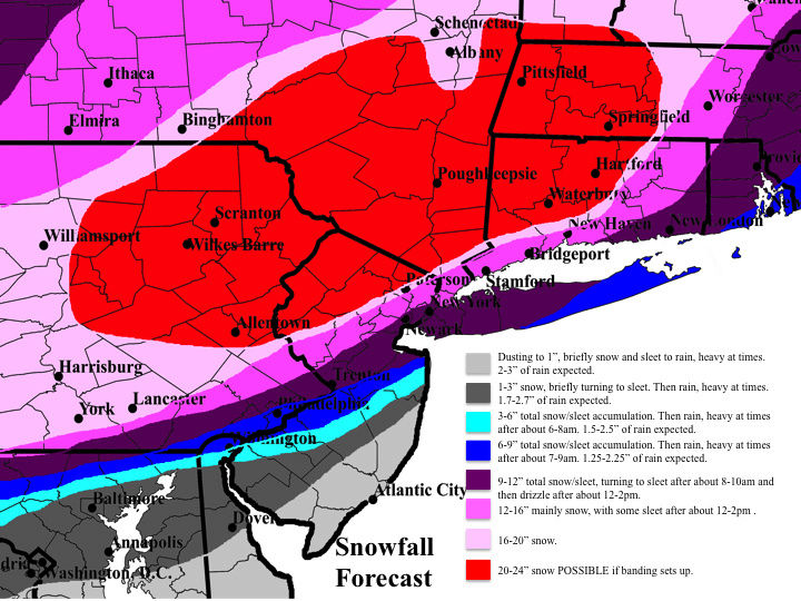
See the maps for the initial thoughts above, but I generally followed a blend of the NAM, SREF, RGEM, UKMET, and EURO suites, although with much less QPF. Unfortunately, I do not have time to go into detail as to why I chose these models and backed off on QPF, but the lack of confluence to the northeast of our system will allow this to be in and out in roughly 12 hours. To get more than 2 feet out of it in that time will be very tough in my opinion, even with ratios, when you take into account time lost to saturate the column and the winding down of the snowfall toward the end. That said, this will still be a very impactful system with extremely heavy snowfall rates at times, making travel nearly impossible, and lowering visibilities to near zero even without any help from wind. As you can see, though, I am expecting the surge of warm air to win out at least for a time along and east of the I-95 corridor. I have several reasons for this, but I do not have time to explain now. Minor to moderate coastal flooding is also expected with astronomical high tides overlapping with the wind and 2-4' storm surge, so coastal communities should be prepared for that. Also. beach erosion will be bad yet again. Sorry for the lack of a post, but I have to get ready for work! Enjoy your afternoons, everybody, and I will return this evening for continued discussion and any updates to my first call!!
Had I been able to issue a Final Call, (yeah, hind sight is 20/20 and I know it's easy to say something after it happens, but please take my word for it), I know that I would have verified better, as I would have increased my max values similarly to Frank's, tightened up my coastal gradient, and likely shifted things a little further westward, since I continued to favor the coastal hugger idea and just would have tweaked lines/numbers. However, this was what I issued to the public, so this is what I'm grading on. I busted too. My orange shading of winds should have extended further west to include much of NJ and more of the LHV/southern New England. My p-type forecast was pretty good, with only a minor northwestward shift needed to verify. My snowfall forecast was much too low for the northern tier of PA and central NY, should have expanded further northwestward, and my coastal snowfall gradient should have been tighter. Again, I feel confident that I would have made most of these changes if a final call was issued, but it wasn't, so even my publicly issued forecast, which was largely west-based with the low track, busted. I was also WAY OFF with my expected duration, as this lasted closer to 18-20 hours for many, rather than 12. I'm right there with you, Frank.
rb924119- Meteorologist
- Posts : 6889
Reputation : 194
Join date : 2013-02-06
Age : 32
Location : Greentown, Pa
Page 2 of 3 • 1, 2, 3 ![]()
|
|
|