
 Search
January 22nd-24th Storm Update / Discussions
Page 1 of 12 • 1, 2, 3 ... 10, 11, 12 ![]()

January 22nd-24th Storm Update / Discussions
![]() by Frank_Wx Fri Jan 20, 2017 8:26 am
by Frank_Wx Fri Jan 20, 2017 8:26 am

The eventual track of the surface low pressure associated with next week's storm depends on what happens at the 500mb level. The EURO and GFS agree a closed 500mb low will be over the Gulf Sunday afternoon. Since it is a closed low, heights are rising ahead of it and sending an easterly fetch of mild air into the east coast. However, there is also a pinched off High Pressure over the Hudson Bay and modeled to drift east-southeast as this storm comes up the coast. This "block" to the north could result in a couple of different scenarios:
1. The ridge to our north and the ridge off the coast link together to keep the surface low on a path to track right along I-95 or west of there. An inland track would bring the worst impacts in my opinion. Heavy rain and high winds. A track along I-95 would still bring heavy rain and high winds, but there would be a dry slot as the center moves over us.
2. The ridge to the north and ridge off the coast remain separate entities, which could allow the 500mb closed low to track off the coast. I am favoring the other scenario at the moment, because I feel a 500mb low closing off in the Southeast with dual 160kt/250mb jet streaks modeled to bring the upper air trough negative will result in a westerly track. Additionally, I feel the High Pressure to the north could track far enough east that it would actually act as a block and try to prevent the surface low from transferring energy to the coast. However, if this storm did track off the coast there is a good shot interior portions of the Northeast, including NEPA and SW NY, could see accumulating snowfall as a backdoor cold front ushers cold air into the region. As the storm deepens, the cold tries to crash to the coast. I would not rule out possible snow for NW NJ either. But I don't see NYC Metro or the immediate coast seeing any snow even if it did take this path.
3. If the block to the north stays over or near the Hudson, then as the primary tries going north, it will transfer energy to the coast and a secondary low will develop. This would also result in less rainfall and even less wind for parts of the area, as the secondary low would likely not strengthen in time to bring us the worst impacts. However, it's possible it does - especially around the BM - which would put the area at risk of heavy rain and wind. This would be a trickier forecast and one some models are hinting at.
Overall, I favor scenarios 1, 3, and 2 in that order.

Here is a look at the dual jet streaks I mentioned. Notice how the 250mb trough goes negative at some point Monday. The dynamics being fed into this storm from the Sub-Tropical Jet and the warm Gulf/Caribbean sea surface temperatures will make this a high impact event. There is a chance the surface low rapidly deepens as it comes up the coast, possibly sub 980mb though I think sub 990mb is most likely. As it strengthens, the rainfall rates and winds will increase.

PWAT, or Precipitable Water, shows where the greatest rainfall potential exists. Basically higher PWAT values means the atmosphere will squeeze out as much water as possible in any given layer of the atmosphere during a storm event, as long as the dynamics are ripe (which they will be). Look at this feed from the Caribbean. If the storm does take an inland track, my concern is flooding for coastal areas from the rain and storm surge. The potential exists for over 3 inches, possibly 4 inches, of rain IF the storm takes the westerly track.
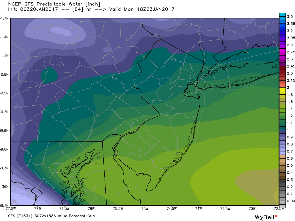
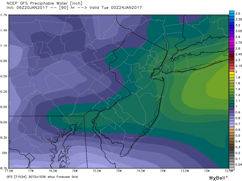
This is a closer view of the PWAT. The Jersey Shore, NYC, and LI are at risk of seeing the highest rainfall rates.
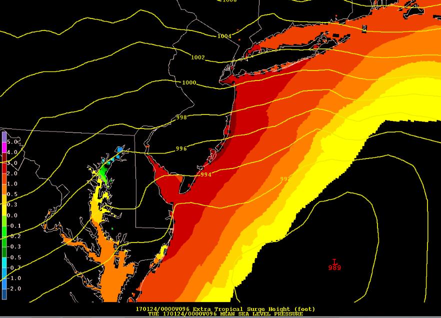
Speaking of storm surge, right now I am thinking 3 to 4 feet for the Jersey Shore which is fairly significant. No matter what an east wind is expected for a period of time which puts the area at risk of coastal flooding. Please use common sense. If 3-4 foot surge brings flooding to your area, I would begin making preparations now...
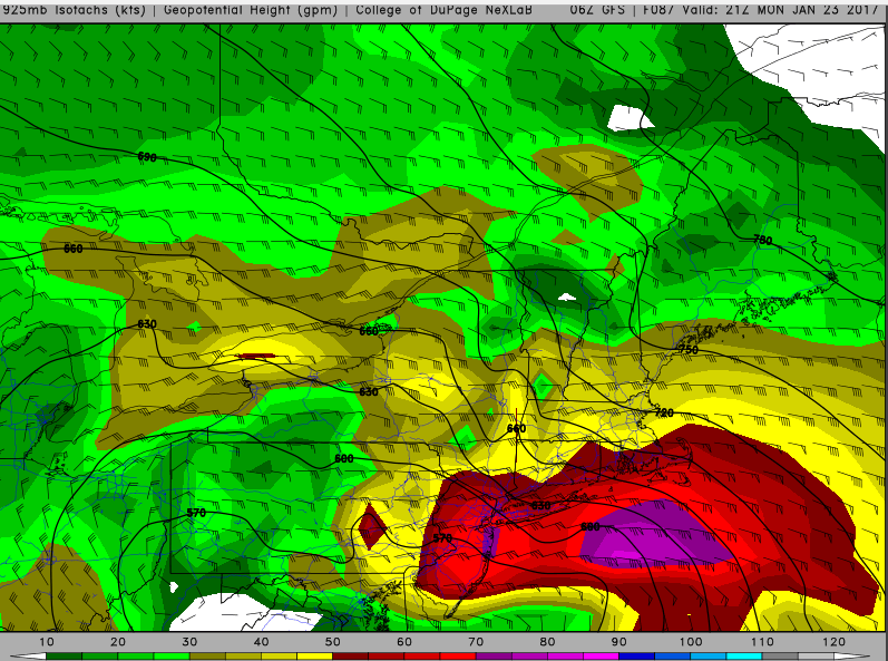
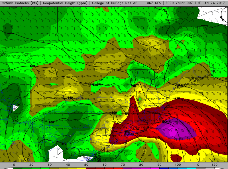
925mb winds are forecasted to be in the 60-70kt range. It will not shock me, depending on track of the surface low, if 925mb winds increase to 80kt (already shown near LI). Given the dynamics at play, and the lack of inversion shown on the soundings, these high winds have a good chance of translating down to the surface. My main concern is that the saturated ground / trees and high winds expected to last over a 24-hour period will result in scattered power outages.
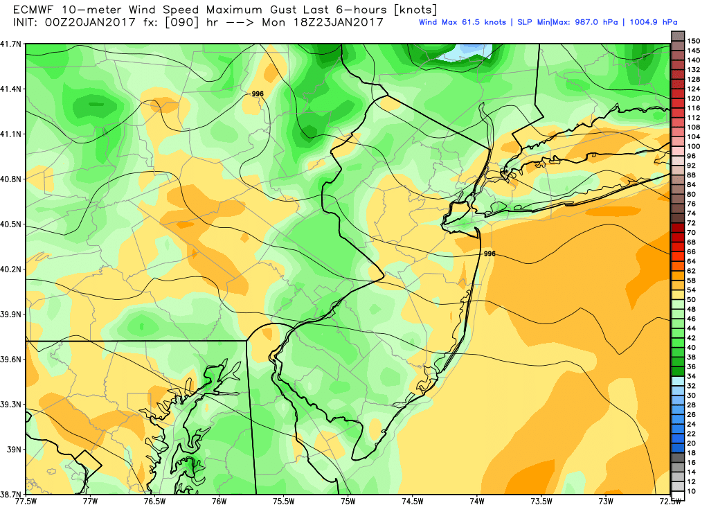
The EURO has wind gusts in the 50-60mph range over at least a 12 hour period. However, 30-40mph gusts are possible over the entire duration of this storm. Wind is always a tricky forecast, and never seems to pan out, but this looks like one system I would not mess with. Even if the winds are strong over a 3-6 hour period, that could be enough to cause some damage to parts of the area. Especially if they gust as high as 60mph or possibly even 70mph in some spots.
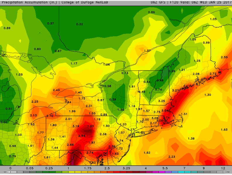
The rainfall forecast depends on exact track. I would say right now the area is in a good spot to see at least 2 inches of rain. I am not buying the model runs showing less than 2 inches of rain at the moment. As stated, depending on track, parts of the area will exceed 3 inches of rain if not more. Couple that with the storm surge and high winds, it's not looking like a pleasant Sunday afternoon through Tuesday morning. Yes, this will be a long duration event. The worst of it looks to be Monday afternoon.
We'll see what models have to say over the next 2 days. But I think ingredients are ripe for a fairly significant event to impact the area. Every town handles flooding differently. Some better than others.
_________________
_______________________________________________________________________________________________________
CLICK HERE to view NJ Strong Snowstorm Classifications

Frank_Wx- Godzilla Seeker

- Posts : 21305
Reputation : 328
Join date : 2013-01-05
Age : 31
Location : Jersey City, NJ -

Re: January 22nd-24th Storm Update / Discussions
![]() by sroc4 Fri Jan 20, 2017 8:38 am
by sroc4 Fri Jan 20, 2017 8:38 am
First I still think snow to the coast is highly unlikely at this time, but still not dead. Areas N&W of I-95 still have a better shot.
Secondly if we want to cont to see a colder soln we MUST see the closed H5 ULL pass S&E of the area, and even then its not a lock. It seems like a consensus is forming that takes the ULL just to the west of the region up the spine of the Appalachians. The energy that forms this storm originates over the warm Pacific ocean, so this storm has to generate its own cold air since we do not have a cold air mass in place.
Third, and this seems to be more clear to me now, is that the system begins to become occluded beginning somewhere over the Tenn Valley and where the LP comes off the DELMARVA area, so by the time it comes off the coast the surface LP is already beginning to weaken, and "fill in" and the precip shield begins to look all ragged and dispersed relative to where you would expect to see it around a surface LP center because the best forcing is no longer associated with the LP center due to this process of occlusion. To read about more details about occlusion of a LP center here is a good link:
https://courseware.e-education.psu.edu/public/meteo/meteo101demo/Examples/Section9p05.html
Timing is everything. There are still differences in the exact timing of occlusion. And if you read the details in the link provided you can see that there are two phases of occlusion.
NOTE: the energy that is this storm, and there is ALOT of it, only comes ashore in the west over the next 18-36hrs, so the best sampling is yet to come. As we have already seen that small last minute trends at H5 can have huge implications on the outcome of the final soln at the surface. So keep an eye on the S/R hi res models as they cont to come into range. If we see them differing to what the globals have been depicting at H5 then red flag; expect shifts for better or worse.
I'm sorry I don't have the time or energy to put up maps this morning. I would love to illustrate my thoughts above; esp the process of occlusion. If I feel better I will def have more details myself, about some of the things I just discussed by tomorrow morning. Now I have to get through today at work. Ugg
When Frank goes silent it usually means he is making up a detailed write up, so expect that soon.
_________________
"In weather and in life, there's no winning and losing; there's only winning and learning."
WINTER 2012/2013 TOTALS 43.65"WINTER 2017/2018 TOTALS 62.85" WINTER 2022/2023 TOTALS 4.9"
WINTER 2013/2014 TOTALS 64.85"WINTER 2018/2019 TOTALS 14.25" WINTER 2023/2024 TOTALS 13.1"
WINTER 2014/2015 TOTALS 71.20"WINTER 2019/2020 TOTALS 6.35"
WINTER 2015/2016 TOTALS 35.00"WINTER 2020/2021 TOTALS 37.75"
WINTER 2016/2017 TOTALS 42.25"WINTER 2021/2022 TOTALS 31.65"

sroc4- Admin
- Posts : 8331
Reputation : 301
Join date : 2013-01-07
Location : Wading River, LI
Re: January 22nd-24th Storm Update / Discussions
![]() by jmanley32 Fri Jan 20, 2017 8:39 am
by jmanley32 Fri Jan 20, 2017 8:39 am
I think it's very possible it may b more than just scattered outages due to as u said duration. I can say from experience here in yonkers we have one of the unhealthy tree and low rooted tree systems around. 45 mph starts to do some damage. 60 mph posdibly plus would b really bad. Sadly since sandy they have cut down hundreds of trees around. We will see what happens. My drive on mon back to ny should b fun glad I don't drive a big rig!

jmanley32- Senior Enthusiast

- Posts : 20513
Reputation : 108
Join date : 2013-12-12
Age : 42
Location : Yonkers, NY
Re: January 22nd-24th Storm Update / Discussions
![]() by sroc4 Fri Jan 20, 2017 8:41 am
by sroc4 Fri Jan 20, 2017 8:41 am
_________________
"In weather and in life, there's no winning and losing; there's only winning and learning."
WINTER 2012/2013 TOTALS 43.65"WINTER 2017/2018 TOTALS 62.85" WINTER 2022/2023 TOTALS 4.9"
WINTER 2013/2014 TOTALS 64.85"WINTER 2018/2019 TOTALS 14.25" WINTER 2023/2024 TOTALS 13.1"
WINTER 2014/2015 TOTALS 71.20"WINTER 2019/2020 TOTALS 6.35"
WINTER 2015/2016 TOTALS 35.00"WINTER 2020/2021 TOTALS 37.75"
WINTER 2016/2017 TOTALS 42.25"WINTER 2021/2022 TOTALS 31.65"
sroc4- Admin
- Posts : 8331
Reputation : 301
Join date : 2013-01-07
Location : Wading River, LI
Re: January 22nd-24th Storm Update / Discussions
![]() by Guest Fri Jan 20, 2017 8:41 am
by Guest Fri Jan 20, 2017 8:41 am
Guest- Guest
Re: January 22nd-24th Storm Update / Discussions
![]() by jmanley32 Fri Jan 20, 2017 8:44 am
by jmanley32 Fri Jan 20, 2017 8:44 am
Its before yours lol. A bag of crushed a holes lol what we're u doing last night lol. Nam looks scary and doesn't appear to show occlusion.sroc4 wrote:Hey guys and gals. I currently feel like a bag of smashed A-holes. I was out like a light last night by 9pm and didn't wake up until about an hr ago. I haven't looked at the details of this storm as I normally do, but Ive looked enough to see a few things.
First I still think snow to the coast is highly unlikely at this time, but still not dead. Areas N&W of I-95 still have a better shot.
Secondly if we want to cont to see a colder soln we MUST see the closed H5 ULL pass S&E of the area, and even then its not a lock. It seems like a consensus is forming that takes the ULL just to the west of the region up the spine of the Appalachians. The energy that forms this storm originates over the warm Pacific ocean, so this storm has to generate its own cold air since we do not have a cold air mass in place.
Third, and this seems to be more clear to me now, is that the system begins to become occluded beginning somewhere over the Tenn Valley and where the LP comes off the DELMARVA area, so by the time it comes off the coast the surface LP is already beginning to weaken, and "fill in" and the precip shield begins to look all ragged and dispersed relative to where you would expect to see it around a surface LP center because the best forcing is no longer associated with the LP center due to this process of occlusion. To read about more details about occlusion of a LP center here is a good link:
https://courseware.e-education.psu.edu/public/meteo/meteo101demo/Examples/Section9p05.html
Timing is everything. There are still differences in the exact timing of occlusion. And if you read the details in the link provided you can see that there are two phases of occlusion.
NOTE: the energy that is this storm, and there is ALOT of it, only comes ashore in the west over the next 18-36hrs, so the best sampling is yet to come. As we have already seen that small last minute trends at H5 can have huge implications on the outcome of the final soln at the surface. So keep an eye on the S/R hi res models as they cont to come into range. If we see them differing to what the globals have been depicting at H5 then red flag; expect shifts for better or worse.
I'm sorry I don't have the time or energy to put up maps this morning. I would love to illustrate my thoughts above; esp the process of occlusion. If I feel better I will def have more details myself, about some of the things I just discussed by tomorrow morning. Now I have to get through today at work. Ugg
When Frank goes silent it usually means he is making up a detailed write up, so expect that soon.
jmanley32- Senior Enthusiast
- Posts : 20513
Reputation : 108
Join date : 2013-12-12
Age : 42
Location : Yonkers, NY
Re: January 22nd-24th Storm Update / Discussions
![]() by rb924119 Fri Jan 20, 2017 8:45 am
by rb924119 Fri Jan 20, 2017 8:45 am
rb924119- Meteorologist

- Posts : 6889
Reputation : 194
Join date : 2013-02-06
Age : 32
Location : Greentown, Pa
Re: January 22nd-24th Storm Update / Discussions
![]() by weatherwatchermom Fri Jan 20, 2017 8:56 am
by weatherwatchermom Fri Jan 20, 2017 8:56 am
sroc4 wrote:See what I mean about Frank. lol
Hope you feel better!!

weatherwatchermom- Senior Enthusiast
- Posts : 3733
Reputation : 77
Join date : 2014-11-25
Age : 60
Location : Hazlet Township, NJ
Re: January 22nd-24th Storm Update / Discussions
![]() by skinsfan1177 Fri Jan 20, 2017 9:04 am
by skinsfan1177 Fri Jan 20, 2017 9:04 am

skinsfan1177- Senior Enthusiast
- Posts : 4485
Reputation : 35
Join date : 2013-01-07
Age : 46
Location : Point Pleasant Boro
Re: January 22nd-24th Storm Update / Discussions
![]() by Frank_Wx Fri Jan 20, 2017 9:06 am
by Frank_Wx Fri Jan 20, 2017 9:06 am
sroc4 wrote:See what I mean about Frank. lol
Went to happy hour last night. Or hours...
_________________
_______________________________________________________________________________________________________
CLICK HERE to view NJ Strong Snowstorm Classifications
Frank_Wx- Godzilla Seeker
- Posts : 21305
Reputation : 328
Join date : 2013-01-05
Age : 31
Location : Jersey City, NJ -
Re: January 22nd-24th Storm Update / Discussions
![]() by rb924119 Fri Jan 20, 2017 9:07 am
by rb924119 Fri Jan 20, 2017 9:07 am
SREFS look pretty good for the northwest. White and cold. Gotta see if it holds.
rb924119- Meteorologist
- Posts : 6889
Reputation : 194
Join date : 2013-02-06
Age : 32
Location : Greentown, Pa
Re: January 22nd-24th Storm Update / Discussions
![]() by Frank_Wx Fri Jan 20, 2017 9:07 am
by Frank_Wx Fri Jan 20, 2017 9:07 am
LONG TERM /SATURDAY NIGHT THROUGH THURSDAY/...
Focus is on a storm forecast to take shape as strong Pacific jet
energy about to come onshore the California coast closes off over
the southern Plains Saturday night, then intensifies on Sunday and
moves up the coast on Monday, as downstream blocking via a full
latitude ridge over the western Atlantic and a closed low east of
Labrador prevent its escape out to sea. One leading low could
approach the Mid Atlantic region on Sunday and bring us some light
rain, then as the closed low becomes negatively tilted over the
Southeast states, the primary low should quickly intensify as it
rides up the coast. As this low moves up the coast, a sharp
pressure gradient between high pressure moving southeast from
Quebec toward the Canadian Maritimes will produce strong winds
along the coast and in the higher interior elevations, and cold
air moving southward with the high looks to make it into the area
from late Sunday night into Monday, with a period of wet snow
across the interior before warmer air moves in aloft. A surface
low track closer to the coast than the ensemble means, and slower
than operational models, is preferred attm.
Potential for strong, possibly damaging easterly winds, continues
to increase. EPS probabilities of sustained 40 mph winds and 60
mph wind gusts continue to remain high for the coastline and now
also for the highest interior elevations, and its probabilities of
45-mph wind gusts are over 50 percent over most of the area. Also,
both GFS and ECMWF MOS continue to predict increasing potential
for sustained winds over 30 mph Mon night into Tue morning,
perhaps as high as 40 mph at the peak of the storm across Long
Island/coastal CT/NYC metro.
A prolonged moderate rainfall of 1-3 inches remains likely as the
storm maintains a tropical moisture connection to the Caribbean
and Eastern Pacific. The rain could become heavy Mon
afternoon/evening especially east of NYC, and maybe even
throughout the region if the low tracks just a little farther
west. With colder air from the Canadian high filtering down into
the region, a period of wet snow is likely across the interior
from late Sunday night into Monday before warmer air moves in
aloft ahead of the low. Amounts should be light, but but as with
several other events this season, could be substantially higher in
the hills of Orange/Putnam/Rockland, and also farther north in
most areas just to the north
_________________
_______________________________________________________________________________________________________
CLICK HERE to view NJ Strong Snowstorm Classifications
Frank_Wx- Godzilla Seeker
- Posts : 21305
Reputation : 328
Join date : 2013-01-05
Age : 31
Location : Jersey City, NJ -
Re: January 22nd-24th Storm Update / Discussions
![]() by rb924119 Fri Jan 20, 2017 9:15 am
by rb924119 Fri Jan 20, 2017 9:15 am
rb924119- Meteorologist
- Posts : 6889
Reputation : 194
Join date : 2013-02-06
Age : 32
Location : Greentown, Pa
Re: January 22nd-24th Storm Update / Discussions
![]() by Frank_Wx Fri Jan 20, 2017 9:27 am
by Frank_Wx Fri Jan 20, 2017 9:27 am

_________________
_______________________________________________________________________________________________________
CLICK HERE to view NJ Strong Snowstorm Classifications
Frank_Wx- Godzilla Seeker
- Posts : 21305
Reputation : 328
Join date : 2013-01-05
Age : 31
Location : Jersey City, NJ -
Re: January 22nd-24th Storm Update / Discussions
![]() by jmanley32 Fri Jan 20, 2017 9:31 am
by jmanley32 Fri Jan 20, 2017 9:31 am
Dayumm, NYC and coastal CT/LI too, what is NMB? Many of those look like freaking hurricanes wow, is there a wind map for those ensembles or just precip? Either way with the isobars u can tell many of those are real bad.Frank_Wx wrote:Some of the NMB's are scary for NJ
jmanley32- Senior Enthusiast
- Posts : 20513
Reputation : 108
Join date : 2013-12-12
Age : 42
Location : Yonkers, NY
Re: January 22nd-24th Storm Update / Discussions
![]() by amugs Fri Jan 20, 2017 9:31 am
by amugs Fri Jan 20, 2017 9:31 am
Frank_Wx wrote:Upton:
LONG TERM /SATURDAY NIGHT THROUGH THURSDAY/...
Focus is on a storm forecast to take shape as strong Pacific jet
energy about to come onshore the California coast closes off over
the southern Plains Saturday night, then intensifies on Sunday and
moves up the coast on Monday, as downstream blocking via a full
latitude ridge over the western Atlantic and a closed low east of
Labrador prevent its escape out to sea. One leading low could
approach the Mid Atlantic region on Sunday and bring us some light
rain, then as the closed low becomes negatively tilted over the
Southeast states, the primary low should quickly intensify as it
rides up the coast. As this low moves up the coast, a sharp
pressure gradient between high pressure moving southeast from
Quebec toward the Canadian Maritimes will produce strong winds
along the coast and in the higher interior elevations, and cold
air moving southward with the high looks to make it into the area
from late Sunday night into Monday, with a period of wet snow
across the interior before warmer air moves in aloft. A surface
low track closer to the coast than the ensemble means, and slower
than operational models, is preferred attm.
Potential for strong, possibly damaging easterly winds, continues
to increase. EPS probabilities of sustained 40 mph winds and 60
mph wind gusts continue to remain high for the coastline and now
also for the highest interior elevations, and its probabilities of
45-mph wind gusts are over 50 percent over most of the area. Also,
both GFS and ECMWF MOS continue to predict increasing potential
for sustained winds over 30 mph Mon night into Tue morning,
perhaps as high as 40 mph at the peak of the storm across Long
Island/coastal CT/NYC metro.
A prolonged moderate rainfall of 1-3 inches remains likely as the
storm maintains a tropical moisture connection to the Caribbean
and Eastern Pacific. The rain could become heavy Mon
afternoon/evening especially east of NYC, and maybe even
throughout the region if the low tracks just a little farther
west. With colder air from the Canadian high filtering down into
the region, a period of wet snow is likely across the interior
from late Sunday night into Monday before warmer air moves in
aloft ahead of the low. Amounts should be light, but but as with
several other events this season, could be substantially higher in
the hills of Orange/Putnam/Rockland, and also farther north in
most areas just to the north
Due us early risers beat you to that 7AM update man - look a page back LOL!!! I posted that whilst you, sroc and rb were snoozing as i had senior study!
Sroc feel better man.
NAM staying open down in the SE lest see where it goes from here

_________________
Mugs
AKA:King: Snow Weenie
Self Proclaimed
WINTER 2014-15 : 55.12" +.02 for 6 coatings (avg. 35")
WINTER 2015-16 Total - 29.8" (Avg 35")
WINTER 2016-17 : 39.5" so far

amugs- Advanced Forecaster - Mod

- Posts : 15093
Reputation : 213
Join date : 2013-01-07
Age : 54
Location : Hillsdale,NJ
Re: January 22nd-24th Storm Update / Discussions
![]() by Frank_Wx Fri Jan 20, 2017 9:32 am
by Frank_Wx Fri Jan 20, 2017 9:32 am
_________________
_______________________________________________________________________________________________________
CLICK HERE to view NJ Strong Snowstorm Classifications
Frank_Wx- Godzilla Seeker
- Posts : 21305
Reputation : 328
Join date : 2013-01-05
Age : 31
Location : Jersey City, NJ -
Re: January 22nd-24th Storm Update / Discussions
![]() by jmanley32 Fri Jan 20, 2017 9:33 am
by jmanley32 Fri Jan 20, 2017 9:33 am
Thats strange thought pretty much all guidance has it as a close low at 500mb by now.amugs wrote:Frank_Wx wrote:Upton:
LONG TERM /SATURDAY NIGHT THROUGH THURSDAY/...
Focus is on a storm forecast to take shape as strong Pacific jet
energy about to come onshore the California coast closes off over
the southern Plains Saturday night, then intensifies on Sunday and
moves up the coast on Monday, as downstream blocking via a full
latitude ridge over the western Atlantic and a closed low east of
Labrador prevent its escape out to sea. One leading low could
approach the Mid Atlantic region on Sunday and bring us some light
rain, then as the closed low becomes negatively tilted over the
Southeast states, the primary low should quickly intensify as it
rides up the coast. As this low moves up the coast, a sharp
pressure gradient between high pressure moving southeast from
Quebec toward the Canadian Maritimes will produce strong winds
along the coast and in the higher interior elevations, and cold
air moving southward with the high looks to make it into the area
from late Sunday night into Monday, with a period of wet snow
across the interior before warmer air moves in aloft. A surface
low track closer to the coast than the ensemble means, and slower
than operational models, is preferred attm.
Potential for strong, possibly damaging easterly winds, continues
to increase. EPS probabilities of sustained 40 mph winds and 60
mph wind gusts continue to remain high for the coastline and now
also for the highest interior elevations, and its probabilities of
45-mph wind gusts are over 50 percent over most of the area. Also,
both GFS and ECMWF MOS continue to predict increasing potential
for sustained winds over 30 mph Mon night into Tue morning,
perhaps as high as 40 mph at the peak of the storm across Long
Island/coastal CT/NYC metro.
A prolonged moderate rainfall of 1-3 inches remains likely as the
storm maintains a tropical moisture connection to the Caribbean
and Eastern Pacific. The rain could become heavy Mon
afternoon/evening especially east of NYC, and maybe even
throughout the region if the low tracks just a little farther
west. With colder air from the Canadian high filtering down into
the region, a period of wet snow is likely across the interior
from late Sunday night into Monday before warmer air moves in
aloft ahead of the low. Amounts should be light, but but as with
several other events this season, could be substantially higher in
the hills of Orange/Putnam/Rockland, and also farther north in
most areas just to the north
Due us early risers beat you to that 7AM update man - look a page back LOL!!! I posted that whilst you, sroc and rb were snoozing as i had senior study!
Sroc feel better man.
NAM staying open down in the SE lest see where it goes from here
jmanley32- Senior Enthusiast
- Posts : 20513
Reputation : 108
Join date : 2013-12-12
Age : 42
Location : Yonkers, NY
Re: January 22nd-24th Storm Update / Discussions
![]() by rb924119 Fri Jan 20, 2017 9:34 am
by rb924119 Fri Jan 20, 2017 9:34 am
rb924119- Meteorologist
- Posts : 6889
Reputation : 194
Join date : 2013-02-06
Age : 32
Location : Greentown, Pa
Re: January 22nd-24th Storm Update / Discussions
![]() by Frank_Wx Fri Jan 20, 2017 9:35 am
by Frank_Wx Fri Jan 20, 2017 9:35 am

_________________
_______________________________________________________________________________________________________
CLICK HERE to view NJ Strong Snowstorm Classifications
Frank_Wx- Godzilla Seeker
- Posts : 21305
Reputation : 328
Join date : 2013-01-05
Age : 31
Location : Jersey City, NJ -
Re: January 22nd-24th Storm Update / Discussions
![]() by rb924119 Fri Jan 20, 2017 9:37 am
by rb924119 Fri Jan 20, 2017 9:37 am
rb924119- Meteorologist
- Posts : 6889
Reputation : 194
Join date : 2013-02-06
Age : 32
Location : Greentown, Pa
Re: January 22nd-24th Storm Update / Discussions
![]() by Frank_Wx Fri Jan 20, 2017 9:37 am
by Frank_Wx Fri Jan 20, 2017 9:37 am
_________________
_______________________________________________________________________________________________________
CLICK HERE to view NJ Strong Snowstorm Classifications
Frank_Wx- Godzilla Seeker
- Posts : 21305
Reputation : 328
Join date : 2013-01-05
Age : 31
Location : Jersey City, NJ -
Re: January 22nd-24th Storm Update / Discussions
![]() by Frank_Wx Fri Jan 20, 2017 9:38 am
by Frank_Wx Fri Jan 20, 2017 9:38 am

_________________
_______________________________________________________________________________________________________
CLICK HERE to view NJ Strong Snowstorm Classifications
Frank_Wx- Godzilla Seeker
- Posts : 21305
Reputation : 328
Join date : 2013-01-05
Age : 31
Location : Jersey City, NJ -
Re: January 22nd-24th Storm Update / Discussions
![]() by jmanley32 Fri Jan 20, 2017 9:39 am
by jmanley32 Fri Jan 20, 2017 9:39 am
jmanley32- Senior Enthusiast
- Posts : 20513
Reputation : 108
Join date : 2013-12-12
Age : 42
Location : Yonkers, NY
Re: January 22nd-24th Storm Update / Discussions
![]() by Frank_Wx Fri Jan 20, 2017 9:39 am
by Frank_Wx Fri Jan 20, 2017 9:39 am

_________________
_______________________________________________________________________________________________________
CLICK HERE to view NJ Strong Snowstorm Classifications
Frank_Wx- Godzilla Seeker
- Posts : 21305
Reputation : 328
Join date : 2013-01-05
Age : 31
Location : Jersey City, NJ -
Page 1 of 12 • 1, 2, 3 ... 10, 11, 12 ![]()
|
|
|