
 Search
End of January - Early February Pattern Change
+8
CPcantmeasuresnow
Dunnzoo
Radz
Armando Salvadore
amugs
sroc4
jmanley32
Frank_Wx
12 posters
Page 2 of 2 •  1, 2
1, 2
Re: End of January - Early February Pattern Change
![]() by Isotherm Sun Jan 15, 2017 1:26 pm
by Isotherm Sun Jan 15, 2017 1:26 pm
After examining the data this morning, the following looks reasonable to me:
1) The initial wave-1 assault on the stratospheric vortex Jan 22-24 will be insufficient in inducing an official warming event. Meridional heat flux and momentum flux becomes more zonal by D10, reflective of a slight decrease in tropospheric wave driving. However, as I have mentioned, the tropospheric precursor pattern will begin to strengthen the Aleutian stratospheric high once again, setting the stage for another increase in wave-1 amplitudes, probably to at least 1400 gpm at 10hpa by the very end of January. This will act to increase geopotential heights across Canada, North America, and the polar regions, with the vortex displaced off-pole. The question becomes, will the wave forcing be sufficiently potent to close the deal? Namely, a continued push of the vortex into Europe w/ a classic displacement event. This will aid in determining the longevity of the upcoming pattern.
2) MJO robust / coherent propagation through P1-2 (see WWB) will result in the lagged tropospheric result with the development of mean troughing in Nino-esque locations. The Aleutian trough and concomitant W Canadian / AK ridging will act contemporaneously with the displacement activity through the stratosphere to raise geopotential heights in the EPO/PNA domains.
3) The AO and NAO will remain largely positive through the beginning of February, reflective of the aforementioned circumstances.
4) The period of favorability should peak in the first 10-11 days of February as the MJO forcing impacts the troposphere, coupled with the stratospheric progression. In the first 10 days of February, a snowstorm is highly probable somewhere in the Eastern US.
5) Beyond February 10th-11th, there are two possible pathways. The low frequency / interseasonal Nina walker cell should return coincident with the decay of the MJO, possibly leading to a worsening of the Pacific pattern as we approach mid February. The question would then become - do we hand off favorability to the Atlantic? This will only be the case if wave driving is sufficiently strong to induce the full SSW in early February. Otherwise, the off-pole displacement will be subsequently be followed by reconsolidation of the vortex at the pol and lowering geopotential heights by week 3. The outcome of the stratosphere is indeterminate, but there will be enough displacement activity to produce a conducive regime for early Feb.
Conclusion: the largest window of opportunity of the winter thus far begins near the end of Jan, through the second week of Feb. The pattern may turn more unfavorable thereafter, but I cannot guarantee that right now.
Isotherm- Advanced Forecaster

- Posts : 231
Join date : 2014-09-01 -

Re: End of January - Early February Pattern Change
![]() by Armando Salvadore Sun Jan 15, 2017 2:35 pm
by Armando Salvadore Sun Jan 15, 2017 2:35 pm
Thanks Tom, great stuff. As many have mentioned, Feb really lies/depends upon what happens with the stratosphere. However, from what has been stated and alluded too by you, our most favorable window of opportunity comes between that aforementioned time period. To follow up your statement about insufficient heat flux, it appears the EPV aren't as poleward as shown a few days ago. However, that doesn't mean it'll affect the short-term implications from another wave forcing. We still will see more forcing by the end of month as that Aleutian high does strengthen. To what extent is in question. It really is a domino effect. If we can manage significant warming to the point of a complete split, we'll see the tropical forcing kick in big time as a cooler tropical troposhere/lower stratosphere becomes a favorable environment for the MJO to thrive in.
Armando Salvadore- Advanced Forecaster
- Posts : 171
Join date : 2016-12-23
Re: End of January - Early February Pattern Change
![]() by Frank_Wx Sun Jan 15, 2017 3:52 pm
by Frank_Wx Sun Jan 15, 2017 3:52 pm
Isotherm wrote:After examining the data this morning, the following looks reasonable to me:
1) The initial wave-1 assault on the stratospheric vortex Jan 22-24 will be insufficient in inducing an official warming event. Meridional heat flux and momentum flux becomes more zonal by D10, reflective of a slight decrease in tropospheric wave driving. However, as I have mentioned, the tropospheric precursor pattern will begin to strengthen the Aleutian stratospheric high once again, setting the stage for another increase in wave-1 amplitudes, probably to at least 1400 gpm at 10hpa by the very end of January. This will act to increase geopotential heights across Canada, North America, and the polar regions, with the vortex displaced off-pole. The question becomes, will the wave forcing be sufficiently potent to close the deal? Namely, a continued push of the vortex into Europe w/ a classic displacement event. This will aid in determining the longevity of the upcoming pattern.
2) MJO robust / coherent propagation through P1-2 (see WWB) will result in the lagged tropospheric result with the development of mean troughing in Nino-esque locations. The Aleutian trough and concomitant W Canadian / AK ridging will act contemporaneously with the displacement activity through the stratosphere to raise geopotential heights in the EPO/PNA domains.
3) The AO and NAO will remain largely positive through the beginning of February, reflective of the aforementioned circumstances.
4) The period of favorability should peak in the first 10-11 days of February as the MJO forcing impacts the troposphere, coupled with the stratospheric progression. In the first 10 days of February, a snowstorm is highly probable somewhere in the Eastern US.
5) Beyond February 10th-11th, there are two possible pathways. The low frequency / interseasonal Nina walker cell should return coincident with the decay of the MJO, possibly leading to a worsening of the Pacific pattern as we approach mid February. The question would then become - do we hand off favorability to the Atlantic? This will only be the case if wave driving is sufficiently strong to induce the full SSW in early February. Otherwise, the off-pole displacement will be subsequently be followed by reconsolidation of the vortex at the pol and lowering geopotential heights by week 3. The outcome of the stratosphere is indeterminate, but there will be enough displacement activity to produce a conducive regime for early Feb.
Conclusion: the largest window of opportunity of the winter thus far begins near the end of Jan, through the second week of Feb. The pattern may turn more unfavorable thereafter, but I cannot guarantee that right now.
Not one thing I disagree with. We're largely in sync. Late January through February 5th (you say 10th) we'll be in a favorable wintry pattern with high probability of seeing our next winter storm event. The pattern beyond the 5th--10th is largely dependent on what happens in the Stratosphere. Unfortunately, mean zonal wind forecasts are better but not showing signs of reversal anymore. Very frustrating, but maybe the Wave 1 the end of this month could be enough. We just don't know yet.
Armando Salvadore wrote:Thanks Tom, great stuff. As many have mentioned, Feb really lies/depends upon what happens with the stratosphere. However, from what has been stated and alluded too by you, our most favorable window of opportunity comes between that aforementioned time period. To follow up your statement about insufficient heat flux, it appears the EPV aren't as poleward as shown a few days ago. However, that doesn't mean it'll affect the short-term implications from another wave forcing. We still will see more forcing by the end of month as that Aleutian high does strengthen. To what extent is in question. It really is a domino effect. If we can manage significant warming to the point of a complete split, we'll see the tropical forcing kick in big time as a cooler tropical troposhere/lower stratosphere becomes a favorable environment for the MJO to thrive in.
Aleutian or Alaskan High? In my readings, I've gathered wave forcing is most favorable when there is a Siberian or Alaskan High, with a large Aleutian trough squeezed in the middle.
_________________
_______________________________________________________________________________________________________
CLICK HERE to view NJ Strong Snowstorm Classifications

Frank_Wx- Godzilla Seeker

- Posts : 21305
Reputation : 328
Join date : 2013-01-05
Age : 31
Location : Jersey City, NJ -
Re: End of January - Early February Pattern Change
![]() by Armando Salvadore Sun Jan 15, 2017 7:14 pm
by Armando Salvadore Sun Jan 15, 2017 7:14 pm
Oh frank i was referring to the Aluetian high up at 10mb that is strengthened via wave 1 forcing from the troposhere reflection by which you just stated.

Armando Salvadore- Advanced Forecaster
- Posts : 171
Reputation : 0
Join date : 2016-12-23
Location : Springfield, NJ
Re: End of January - Early February Pattern Change
![]() by Frank_Wx Sun Jan 15, 2017 7:26 pm
by Frank_Wx Sun Jan 15, 2017 7:26 pm
Ahhhhhh all good
_________________
_______________________________________________________________________________________________________
CLICK HERE to view NJ Strong Snowstorm Classifications
Frank_Wx- Godzilla Seeker
- Posts : 21305
Reputation : 328
Join date : 2013-01-05
Age : 31
Location : Jersey City, NJ -
Re: End of January - Early February Pattern Change
![]() by Isotherm Sun Jan 15, 2017 10:01 pm
by Isotherm Sun Jan 15, 2017 10:01 pm
Armando Salvadore wrote:Thanks Tom, great stuff. As many have mentioned, Feb really lies/depends upon what happens with the stratosphere. However, from what has been stated and alluded too by you, our most favorable window of opportunity comes between that aforementioned time period. To follow up your statement about insufficient heat flux, it appears the EPV aren't as poleward as shown a few days ago. However, that doesn't mean it'll affect the short-term implications from another wave forcing. We still will see more forcing by the end of month as that Aleutian high does strengthen. To what extent is in question. It really is a domino effect. If we can manage significant warming to the point of a complete split, we'll see the tropical forcing kick in big time as a cooler tropical troposhere/lower stratosphere becomes a favorable environment for the MJO to thrive in.
Thanks Armando, fully agree. Should be interesting to see how things evolve.
Isotherm- Advanced Forecaster
- Posts : 231
Reputation : 4
Join date : 2014-09-01
Age : 33
Location : Monmouth County, NJ -
Re: End of January - Early February Pattern Change
![]() by Frank_Wx Thu Jan 19, 2017 9:21 am
by Frank_Wx Thu Jan 19, 2017 9:21 am
I will be issuing an updated video this weekend or early next week. At the end of this video I mentioned if the Stratosphere cooperates, it could lead to a colder than normal temp regime that is sustainable for most of February. As of this morning, I feel confident these changes will come to fruition in the form of a SSWE.
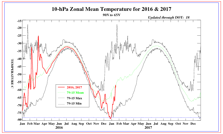
Current observations show 10hPa temperatures in the polar region rising rapidly. This is a result of a current increase in WAF from a large Siberian High dominating that region. Poleward EPV, in conjunction with drastic weakening of the 1hPa mean zonal winds, is already "stressing" the PV out.
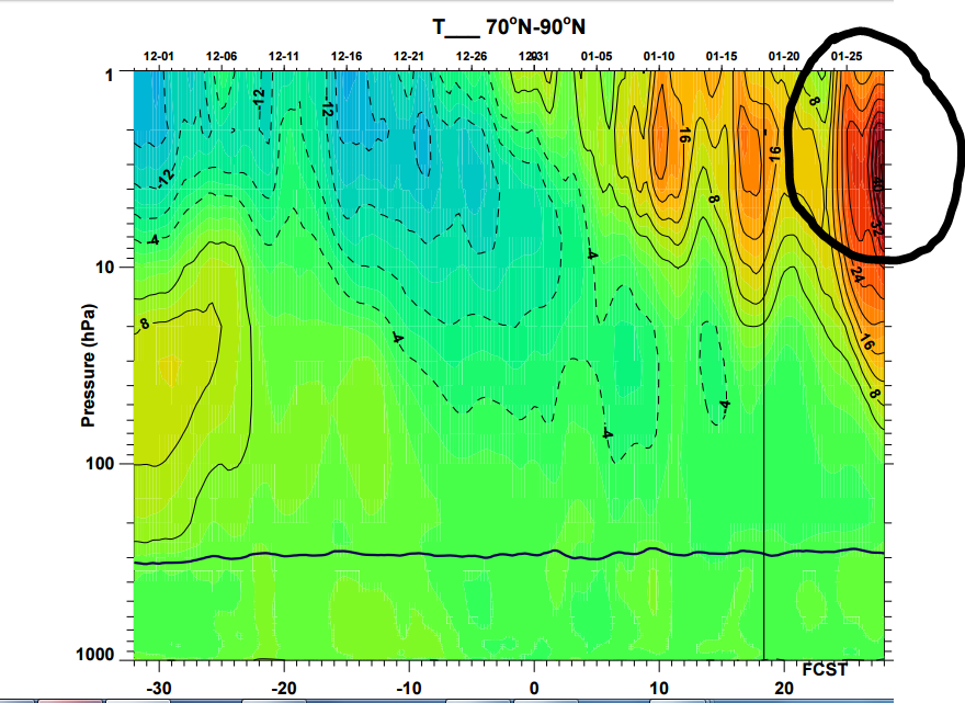
The Wave 1 attack that is forecasted is what excites me. All models are showing a sudden strat warming between 1hPa - 10hPa (upper level Strat). Check out these temperatures (circled) in the Day 8 to 15 range. Models are beginning to show this warmth bleed into the middle levels of the Stratosphere too. As geopotential heights build from the Pacific/Siberia, the PV will be pushed completely off the North Pole into eastern Europe. As a result, the AO is likely to go negative and the Trop PV will move southward into eastern Canada.
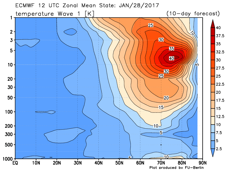
The heart of the Wave 1 warming will take place at 10hPa. As mentioned, this forecast keeps growing more bullish by the day. This is a forecast from the EURO.
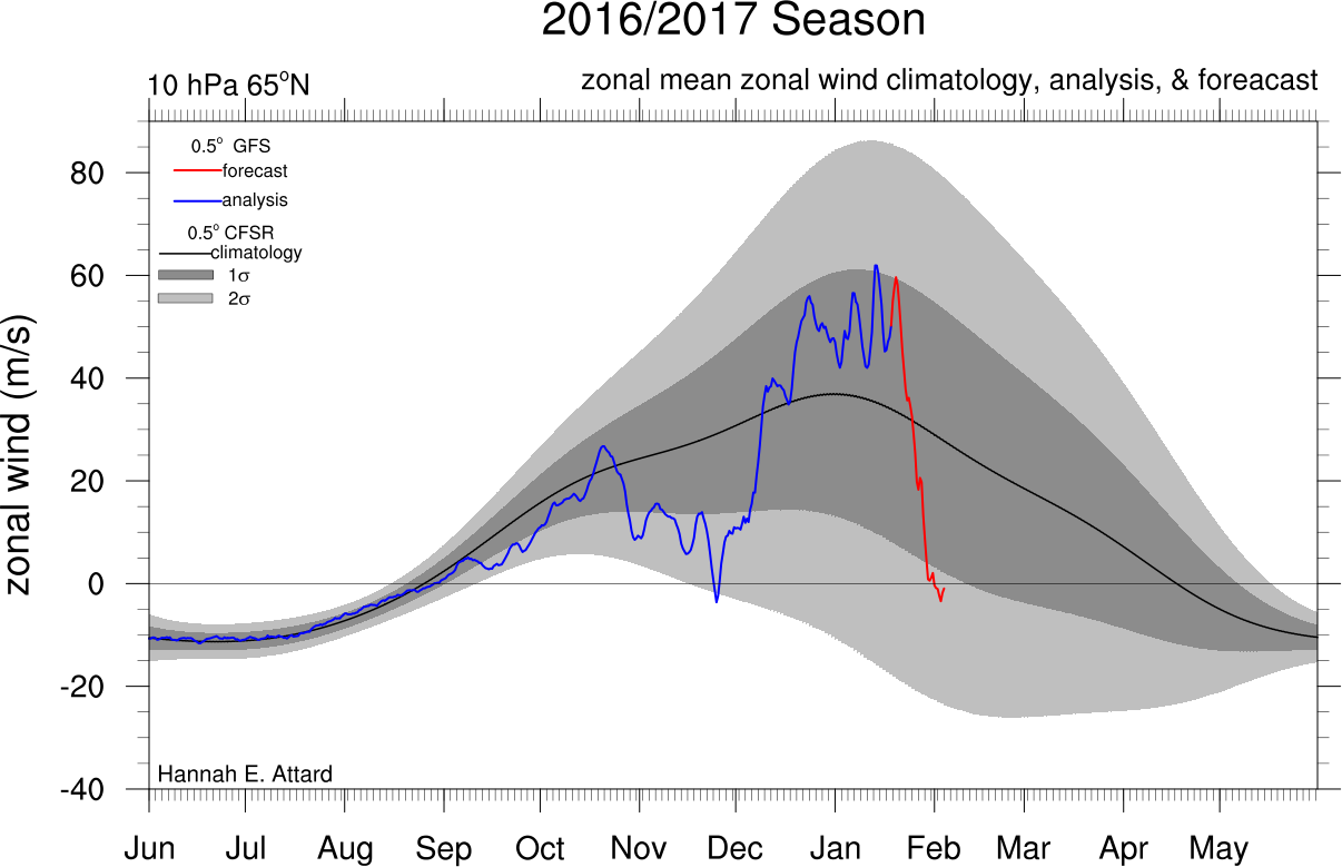
Further, we're now seeing signs mean zonal winds will reverse easterly at 10hPa/60N. This steep drop off in wind speeds weakens the PV to state that makes it vulnerable to the Wave 1 warming event.
What's left is a SSWE. Let me warn by saying it's not a "technical" SSWE until mean zonal winds fully reverse and the Strat PV is destroyed or split in half. Models are showing the wind reversal, but they're not yet sold on the Strat PV being completely destroyed. In my eyes, it should still be considered a SSWE because it will have drastic impacts on our 500mb pattern the first half of February. By the time the Strat PV moves back over the NPole (if it does so at all) the month will be half way through but the 500mb pattern will already be established thank to the Wave 1 event.
So what I'm thinking is my original time frame of January 27th - February 5th will come to fruition, specifically seeing a pattern change on January 27th. But after I review the data this weekend I will likely be inclined to say the colder than normal pattern will last beyond the 5th. Possibly until the middle or 3rd week of February. I also feel there is a higher than normal probability of a Godzilla impacting the area in February.
Current observations show 10hPa temperatures in the polar region rising rapidly. This is a result of a current increase in WAF from a large Siberian High dominating that region. Poleward EPV, in conjunction with drastic weakening of the 1hPa mean zonal winds, is already "stressing" the PV out.
The Wave 1 attack that is forecasted is what excites me. All models are showing a sudden strat warming between 1hPa - 10hPa (upper level Strat). Check out these temperatures (circled) in the Day 8 to 15 range. Models are beginning to show this warmth bleed into the middle levels of the Stratosphere too. As geopotential heights build from the Pacific/Siberia, the PV will be pushed completely off the North Pole into eastern Europe. As a result, the AO is likely to go negative and the Trop PV will move southward into eastern Canada.
The heart of the Wave 1 warming will take place at 10hPa. As mentioned, this forecast keeps growing more bullish by the day. This is a forecast from the EURO.
Further, we're now seeing signs mean zonal winds will reverse easterly at 10hPa/60N. This steep drop off in wind speeds weakens the PV to state that makes it vulnerable to the Wave 1 warming event.
What's left is a SSWE. Let me warn by saying it's not a "technical" SSWE until mean zonal winds fully reverse and the Strat PV is destroyed or split in half. Models are showing the wind reversal, but they're not yet sold on the Strat PV being completely destroyed. In my eyes, it should still be considered a SSWE because it will have drastic impacts on our 500mb pattern the first half of February. By the time the Strat PV moves back over the NPole (if it does so at all) the month will be half way through but the 500mb pattern will already be established thank to the Wave 1 event.
So what I'm thinking is my original time frame of January 27th - February 5th will come to fruition, specifically seeing a pattern change on January 27th. But after I review the data this weekend I will likely be inclined to say the colder than normal pattern will last beyond the 5th. Possibly until the middle or 3rd week of February. I also feel there is a higher than normal probability of a Godzilla impacting the area in February.
_________________
_______________________________________________________________________________________________________
CLICK HERE to view NJ Strong Snowstorm Classifications
Frank_Wx- Godzilla Seeker
- Posts : 21305
Reputation : 328
Join date : 2013-01-05
Age : 31
Location : Jersey City, NJ -
Re: End of January - Early February Pattern Change
![]() by billg315 Thu Jan 19, 2017 9:35 am
by billg315 Thu Jan 19, 2017 9:35 am
So without reversal of the winds or complete split of the PV, would this then be categorized as a minor SSW? And if so, how much of a difference is there in terms of surface level effects of a minor vs a major SSWE?

billg315- Advanced Forecaster - Mod

- Posts : 4466
Reputation : 185
Join date : 2015-01-24
Age : 50
Location : Flemington, NJ
Re: End of January - Early February Pattern Change
![]() by Frank_Wx Thu Jan 19, 2017 9:39 am
by Frank_Wx Thu Jan 19, 2017 9:39 am
Yes, it would be minor. The difference between a minor and major is that with minor the impact at 500mb would be temporary. But in this case, since this "minor" event is expected to last over a 10 day period, it will have a great impact on our sensible weather. With major, the changes are everlasting at 500mb and normally keep us cold over a long period of time that could last into March.
_________________
_______________________________________________________________________________________________________
CLICK HERE to view NJ Strong Snowstorm Classifications
Frank_Wx- Godzilla Seeker
- Posts : 21305
Reputation : 328
Join date : 2013-01-05
Age : 31
Location : Jersey City, NJ -
Re: End of January - Early February Pattern Change
![]() by billg315 Thu Jan 19, 2017 9:54 am
by billg315 Thu Jan 19, 2017 9:54 am
Frank_Wx wrote:Yes, it would be minor. The difference between a minor and major is that with minor the impact at 500mb would be temporary. But in this case, since this "minor" event is expected to last over a 10 day period, it will have a great impact on our sensible weather. With major, the changes are everlasting at 500mb and normally keep us cold over a long period of time that could last into March.
Got it. Thanks! To be honest a 10-14 day period would be good enough for me right now, especially if we can get a couple really good snow opportunities out of it.
billg315- Advanced Forecaster - Mod
- Posts : 4466
Reputation : 185
Join date : 2015-01-24
Age : 50
Location : Flemington, NJ
Page 2 of 2 • 1, 2
Permissions in this forum:
You cannot reply to topics in this forum|
|
|