
 Search
February 12th-13th 2024 Pre-Valentines Day Storm Potential
Page 12 of 13 •  1, 2, 3 ... , 11, 12, 13
 ![]()
Re: February 12th-13th 2024 Pre-Valentines Day Storm Potential
![]() by sroc4 Mon Feb 12, 2024 11:12 am
by sroc4 Mon Feb 12, 2024 11:12 am
sroc4- Admin

- Posts : 8331
Join date : 2013-01-07
essexcountypete and MattyICE like this post
Re: February 12th-13th 2024 Pre-Valentines Day Storm Potential
![]() by essexcountypete Mon Feb 12, 2024 11:12 am
by essexcountypete Mon Feb 12, 2024 11:12 am
Irish wrote:essexcountypete wrote:Irish wrote:Okay, we can stop with any further updates or changes now that that dark purple strip is over my area. Fire wood ready and selecting my movie list for tomorrow. This solution would be solid for most on this board.Frank_Wx wrote:GFS just went Godzilla
My first thought when I saw that map was "oh Irish will like that one" LOL!!! LOCK IT IN!!!
Mom should be loving that as well.come on, really?! That was your first thought?! Hysterical! You would've thought I made that map.

Totally! How often do you see the lollipop jackpot show up on Monmouth/Middlesex?
(just don't count on it staying there
essexcountypete- Pro Enthusiast

- Posts : 783
Join date : 2013-12-09
weatherwatchermom likes this post
Re: February 12th-13th 2024 Pre-Valentines Day Storm Potential
![]() by CPcantmeasuresnow Mon Feb 12, 2024 11:13 am
by CPcantmeasuresnow Mon Feb 12, 2024 11:13 am
Irish wrote:Okay, we can stop with any further updates or changes now that that dark purple strip is over my area. Fire wood ready and selecting my movie list for tomorrow. This solution would be solid for most on this board.Frank_Wx wrote:GFS just went Godzilla
He says with the max area overheard LOL.
Listen I'll take the 10-12 it now has over me and sacrifice the higher amounts for the good of the board but that cutoff to my north is getting to close for comfort. Personally I wouldn't mind a 25 mile shift north today.
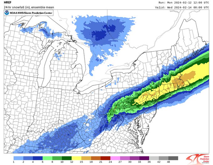
Of course any individual model run we see today should be taken with a grain of salt. Also remeber the 10:1 ratio snow maps are BS, the areas of 15-18 over CNJ probably more like 10-12 with a proper kuchera map. Try to use a blend of each set of runs and concentrate on that. Whatever you see on a map today will probably not unfold exactly as you see it anyway.
This will band and dryslot as it sees fit along with areas of subsidence that will always happen in a storm like this. Always remember that and keep expectations in check. A word of advice from a recovering Snowcaholic.
Last edited by CPcantmeasuresnow on Mon Feb 12, 2024 11:17 am; edited 2 times in total

CPcantmeasuresnow- Wx Statistician Guru

- Posts : 7274
Reputation : 230
Join date : 2013-01-07
Age : 103
Location : Eastern Orange County, NY
docstox12, kalleg and dkodgis like this post
Re: February 12th-13th 2024 Pre-Valentines Day Storm Potential
![]() by amugs Mon Feb 12, 2024 11:15 am
by amugs Mon Feb 12, 2024 11:15 am

_________________
Mugs
AKA:King: Snow Weenie
Self Proclaimed
WINTER 2014-15 : 55.12" +.02 for 6 coatings (avg. 35")
WINTER 2015-16 Total - 29.8" (Avg 35")
WINTER 2016-17 : 39.5" so far

amugs- Advanced Forecaster - Mod

- Posts : 15093
Reputation : 213
Join date : 2013-01-07
Age : 54
Location : Hillsdale,NJ
Re: February 12th-13th 2024 Pre-Valentines Day Storm Potential
![]() by amugs Mon Feb 12, 2024 11:18 am
by amugs Mon Feb 12, 2024 11:18 am
Remember this is a 10:1 map not going to be most so take about 3-4" off for lower ration - coastal plain regions
_________________
Mugs
AKA:King: Snow Weenie
Self Proclaimed
WINTER 2014-15 : 55.12" +.02 for 6 coatings (avg. 35")
WINTER 2015-16 Total - 29.8" (Avg 35")
WINTER 2016-17 : 39.5" so far
amugs- Advanced Forecaster - Mod
- Posts : 15093
Reputation : 213
Join date : 2013-01-07
Age : 54
Location : Hillsdale,NJ
Re: February 12th-13th 2024 Pre-Valentines Day Storm Potential
![]() by weatherwatchermom Mon Feb 12, 2024 11:25 am
by weatherwatchermom Mon Feb 12, 2024 11:25 am
essexcountypete wrote:Irish wrote:Okay, we can stop with any further updates or changes now that that dark purple strip is over my area. Fire wood ready and selecting my movie list for tomorrow. This solution would be solid for most on this board.Frank_Wx wrote:GFS just went Godzilla
My first thought when I saw that map was "oh Irish will like that one" LOL!!! LOCK IT IN!!!
Mom should be loving that as well.
I looked at that post and busted out laughing...all I kept seeing is coastal flood warning and maybe a trace and then this pops up. Lol I will believe when I see it..

weatherwatchermom- Senior Enthusiast

- Posts : 3738
Reputation : 77
Join date : 2014-11-25
Age : 60
Location : Hazlet Township, NJ
Re: February 12th-13th 2024 Pre-Valentines Day Storm Potential
![]() by heehaw453 Mon Feb 12, 2024 11:26 am
by heehaw453 Mon Feb 12, 2024 11:26 am

heehaw453- Advanced Forecaster

- Posts : 3906
Reputation : 86
Join date : 2014-01-20
Location : Bedminster Township, PA Elevation 600' ASL
Re: February 12th-13th 2024 Pre-Valentines Day Storm Potential
![]() by sroc4 Mon Feb 12, 2024 11:27 am
by sroc4 Mon Feb 12, 2024 11:27 am
CPcantmeasuresnow wrote:Irish wrote:Okay, we can stop with any further updates or changes now that that dark purple strip is over my area. Fire wood ready and selecting my movie list for tomorrow. This solution would be solid for most on this board.Frank_Wx wrote:GFS just went Godzilla
He says with the max area overheard LOL.
Listen I'll take the 10-12 it now has over me and sacrifice the higher amounts for the good of the board but that cutoff to my north is getting to close for comfort. Personally I wouldn't mind a 25 mile shift north today.
Of course any individual model run we see today should be taken with a grain of salt. Also remeber the 10:1 ratio snow maps are BS, the areas of 15-18 over CNJ probably more like 10-12 with a proper kuchera map. Try to use a blend of each set of runs and concentrate on that. Whatever you see on a map today will probably not unfold exactly as you see it anyway.
This will band and dryslot as it sees fit along with areas of subsidence that will always happen in a storm like this. Always remember that and keep expectations in check. A word of advice from a recovering Snowcaholic.
Here is your GFS Kuchera Map

_________________
"In weather and in life, there's no winning and losing; there's only winning and learning."
WINTER 2012/2013 TOTALS 43.65"WINTER 2017/2018 TOTALS 62.85" WINTER 2022/2023 TOTALS 4.9"
WINTER 2013/2014 TOTALS 64.85"WINTER 2018/2019 TOTALS 14.25" WINTER 2023/2024 TOTALS 13.1"
WINTER 2014/2015 TOTALS 71.20"WINTER 2019/2020 TOTALS 6.35"
WINTER 2015/2016 TOTALS 35.00"WINTER 2020/2021 TOTALS 37.75"
WINTER 2016/2017 TOTALS 42.25"WINTER 2021/2022 TOTALS 31.65"

sroc4- Admin
- Posts : 8331
Reputation : 301
Join date : 2013-01-07
Location : Wading River, LI
Re: February 12th-13th 2024 Pre-Valentines Day Storm Potential
![]() by Irish Mon Feb 12, 2024 11:30 am
by Irish Mon Feb 12, 2024 11:30 am
Never, and if it is does, it's because the entire state is getting a Miller A and it's area wide explosion! I certainly don't count on it staying exactly there, but with being this close to the storm hitting, I like where we're at.essexcountypete wrote:Irish wrote:essexcountypete wrote:Irish wrote:Okay, we can stop with any further updates or changes now that that dark purple strip is over my area. Fire wood ready and selecting my movie list for tomorrow. This solution would be solid for most on this board.Frank_Wx wrote:GFS just went Godzilla
My first thought when I saw that map was "oh Irish will like that one" LOL!!! LOCK IT IN!!!
Mom should be loving that as well.
Totally! How often do you see the lollipop jackpot show up on Monmouth/Middlesex?
(just don't count on it staying there)

Irish- Pro Enthusiast
- Posts : 788
Reputation : 19
Join date : 2019-01-16
Age : 45
Location : Old Bridge, NJ
essexcountypete likes this post
Re: February 12th-13th 2024 Pre-Valentines Day Storm Potential
![]() by amugs Mon Feb 12, 2024 11:31 am
by amugs Mon Feb 12, 2024 11:31 am
_________________
Mugs
AKA:King: Snow Weenie
Self Proclaimed
WINTER 2014-15 : 55.12" +.02 for 6 coatings (avg. 35")
WINTER 2015-16 Total - 29.8" (Avg 35")
WINTER 2016-17 : 39.5" so far
amugs- Advanced Forecaster - Mod
- Posts : 15093
Reputation : 213
Join date : 2013-01-07
Age : 54
Location : Hillsdale,NJ
Re: February 12th-13th 2024 Pre-Valentines Day Storm Potential
![]() by heehaw453 Mon Feb 12, 2024 11:34 am
by heehaw453 Mon Feb 12, 2024 11:34 am

heehaw453- Advanced Forecaster
- Posts : 3906
Reputation : 86
Join date : 2014-01-20
Location : Bedminster Township, PA Elevation 600' ASL
MattyICE likes this post
Re: February 12th-13th 2024 Pre-Valentines Day Storm Potential
![]() by amugs Mon Feb 12, 2024 11:35 am
by amugs Mon Feb 12, 2024 11:35 am

GFS metograms show NYC puking snow from 7AM though Noon!!
1.5" of Precip - GOD IF ONLY WE HAD A QUEBEC HP ANCHORED OVERHEAD!!
_________________
Mugs
AKA:King: Snow Weenie
Self Proclaimed
WINTER 2014-15 : 55.12" +.02 for 6 coatings (avg. 35")
WINTER 2015-16 Total - 29.8" (Avg 35")
WINTER 2016-17 : 39.5" so far
amugs- Advanced Forecaster - Mod
- Posts : 15093
Reputation : 213
Join date : 2013-01-07
Age : 54
Location : Hillsdale,NJ
Re: February 12th-13th 2024 Pre-Valentines Day Storm Potential
![]() by nutleyblizzard Mon Feb 12, 2024 11:38 am
by nutleyblizzard Mon Feb 12, 2024 11:38 am

The Canadian crushes us too.

nutleyblizzard- Senior Enthusiast
- Posts : 1952
Reputation : 41
Join date : 2014-01-30
Age : 58
Location : Nutley, new jersey
essexcountypete, jmanley32 and MattyICE like this post
Re: February 12th-13th 2024 Pre-Valentines Day Storm Potential
![]() by jmanley32 Mon Feb 12, 2024 11:45 am
by jmanley32 Mon Feb 12, 2024 11:45 am
Actually me too Irish lol, this is insane, now snow gets down to central and parts of southern NJ and that strip your in is oriented very interestingly. But wow not complaining at all! Will it happen? It is anybody's guess.Irish wrote:essexcountypete wrote:Irish wrote:Okay, we can stop with any further updates or changes now that that dark purple strip is over my area. Fire wood ready and selecting my movie list for tomorrow. This solution would be solid for most on this board.Frank_Wx wrote:GFS just went Godzilla
My first thought when I saw that map was "oh Irish will like that one" LOL!!! LOCK IT IN!!!
Mom should be loving that as well.

jmanley32- Senior Enthusiast
- Posts : 20516
Reputation : 108
Join date : 2013-12-12
Age : 42
Location : Yonkers, NY
essexcountypete and Irish like this post
Re: February 12th-13th 2024 Pre-Valentines Day Storm Potential
![]() by CPcantmeasuresnow Mon Feb 12, 2024 11:56 am
by CPcantmeasuresnow Mon Feb 12, 2024 11:56 am
nutleyblizzard wrote:
The Canadian crushes us too.
That 12 over my house is nice but 30 miles north, that's a sharp cutoff, extreme even.
It's looking more and more like it will be a nail biter for those on the north and south end of the high totals, just for different reasons.
CPcantmeasuresnow- Wx Statistician Guru
- Posts : 7274
Reputation : 230
Join date : 2013-01-07
Age : 103
Location : Eastern Orange County, NY
2004blackwrx and SENJsnowman like this post
Re: February 12th-13th 2024 Pre-Valentines Day Storm Potential
![]() by jmanley32 Mon Feb 12, 2024 12:09 pm
by jmanley32 Mon Feb 12, 2024 12:09 pm
It is all nice CP for majority verbatim and pretty much all models have a similar snow output (yes looking at the snow maps, your point was well taken) but what I take is there is consistency across all of them for a 10+ inch snowfall for PA, NNJ NYC, And all of Hudson Valley up to just north of you. Looks possible even for central to even slightly south of central NJ like on GFS. Lets just pray these hold and don't move a lot (they also all have pretty much the same axis of the snowfall placement), we are well under 24 hrs now till game time so lets see, personally the snow maps don't mean much at this pt though Euro will be interesting to see.CPcantmeasuresnow wrote:nutleyblizzard wrote:
The Canadian crushes us too.
That 12 over my house is nice but 30 miles north, that's a sharp cutoff, extreme even.
It's looking more and more like it will be a nail biter for those on the north and south end of the high totals, just for different reasons.
jmanley32- Senior Enthusiast
- Posts : 20516
Reputation : 108
Join date : 2013-12-12
Age : 42
Location : Yonkers, NY
SENJsnowman likes this post
Re: February 12th-13th 2024 Pre-Valentines Day Storm Potential
![]() by docstox12 Mon Feb 12, 2024 12:47 pm
by docstox12 Mon Feb 12, 2024 12:47 pm
CPcantmeasuresnow wrote:nutleyblizzard wrote:
The Canadian crushes us too.
That 12 over my house is nice but 30 miles north, that's a sharp cutoff, extreme even.
It's looking more and more like it will be a nail biter for those on the north and south end of the high totals, just for different reasons.
I think it was much easier and stress free back in the day, some 60 years ago, when all you had was the 1/2 hourly radio news forecasts and the evening tv weather folks.Then you waited for that day and got a good or a bad surprise, and I had many of both.You observed out your window and knew after a couple of hours what was going to happen.Saw a great surprise for the Dec,11-12 1960 snowstorm( they had forecasted 4 inches and it was over 20) and a bad suprise( March 1962 Superstorm forecasted over a foot and got a dusting).Let's hope this thing bombs out and the precip field expands big time so everybody gets in on the goods.

docstox12- Wx Statistician Guru
- Posts : 8504
Reputation : 222
Join date : 2013-01-07
Age : 73
Location : Monroe NY
kalleg, essexcountypete, GreyBeard, weatherwatchermom and billg315 like this post
Re: February 12th-13th 2024 Pre-Valentines Day Storm Potential
![]() by billg315 Mon Feb 12, 2024 12:49 pm
by billg315 Mon Feb 12, 2024 12:49 pm
1. Liquid equivalents are pretty high on some models which is fueling some of these snow totals. But, I often think the GPS overdoes precipitation totals and I also think this will be less of a 10:1 maybe more of a 8:1 ratio event so the 10:1 maps might be a bit high.
2. Some models are showing sleet mixing in during the transition period. Models never do well with this in terms of factoring it into snow maps. It negatively affects accumulation amounts (obviously).
3. Ground will be just above freezing at outset, so really need the heavy rates to set in for this to start sticking. Once it does, it should pile up quick, but we could lose a couple (a few?) hours at the outset while the lighter precip doesn't accumulate right away. It will however help that it is starting at night and by the time the sun comes up, it should be getting heavy already.
Therefore, I'd take these snow maps and maybe read them with a conservative eye. Maybe shave a couple inches off the verbatim outputs. This is still a significant storm, but I don't want people expecting 12" and being disappointed if they get 8 or 9" in their area.

billg315- Advanced Forecaster - Mod
- Posts : 4466
Reputation : 185
Join date : 2015-01-24
Age : 50
Location : Flemington, NJ
amugs, essexcountypete, jmanley32, GreyBeard and weatherwatchermom like this post
Re: February 12th-13th 2024 Pre-Valentines Day Storm Potential
![]() by amugs Mon Feb 12, 2024 1:00 pm
by amugs Mon Feb 12, 2024 1:00 pm
billg315 wrote:A few thoughts at present which may change with the wind as they say:
1. Liquid equivalents are pretty high on some models which is fueling some of these snow totals. But, I often think the GPS overdoes precipitation totals and I also think this will be less of a 10:1 maybe more of a 8:1 ratio event so the 10:1 maps might be a bit high.
2. Some models are showing sleet mixing in during the transition period. Models never do well with this in terms of factoring it into snow maps. It negatively affects accumulation amounts (obviously).
3. Ground will be just above freezing at outset, so really need the heavy rates to set in for this to start sticking. Once it does, it should pile up quick, but we could lose a couple (a few?) hours at the outset while the lighter precip doesn't accumulate right away. It will however help that it is starting at night and by the time the sun comes up, it should be getting heavy already.
Therefore, I'd take these snow maps and maybe read them with a conservative eye. Maybe shave a couple inches off the verbatim outputs. This is still a significant storm, but I don't want people expecting 12" and being disappointed if they get 8 or 9" in their area.
Therefore
Kuchera maps are better in this marginal set up.
I'm looking at 5-8" here even though the maps may say 12" - not a truly arctic air mass again, if there was then those would be much better, realistic to use.
_________________
Mugs
AKA:King: Snow Weenie
Self Proclaimed
WINTER 2014-15 : 55.12" +.02 for 6 coatings (avg. 35")
WINTER 2015-16 Total - 29.8" (Avg 35")
WINTER 2016-17 : 39.5" so far
amugs- Advanced Forecaster - Mod
- Posts : 15093
Reputation : 213
Join date : 2013-01-07
Age : 54
Location : Hillsdale,NJ
Re: February 12th-13th 2024 Pre-Valentines Day Storm Potential
![]() by DAYBLAZER Mon Feb 12, 2024 1:04 pm
by DAYBLAZER Mon Feb 12, 2024 1:04 pm
billg315 wrote:This is still a significant storm, but I don't want people expecting 12" and being disappointed if they get 8 or 9" in their area.
This right here ^^ couldn't have said it better myself. I think it's important for everyone to view the next 24 hours as a gift, no matter what. 3-4 years ago, I would have been 'that guy' you are referencing. But if the last few winters have taught me anything, it's that any snow is good snow, and this will be 'good snow' for me whether I get 4 inches or 12 inches IMBY. I have been humbled by Mother Nature and no longer 'expect' big storms just because it's winter.
Not to mention, we all get to enjoy the 'track.' Nothing better than having something out there that warrants it's own thread, and another thread for snow maps. That right there is why this forum exists, and it's an absolute pleasure to obsessively check in on this forum for discussion and excellent analysis in the hours leading up to a potential 'big event.'

DAYBLAZER- Posts : 228
Reputation : 20
Join date : 2017-03-12
Location : Hopatcong, NJ Sussex County
sroc4, docstox12, kalleg, essexcountypete, weatherwatchermom, billg315 and SENJsnowman like this post
Re: February 12th-13th 2024 Pre-Valentines Day Storm Potential
![]() by phil155 Mon Feb 12, 2024 1:06 pm
by phil155 Mon Feb 12, 2024 1:06 pm
phil155- Pro Enthusiast
- Posts : 475
Reputation : 4
Join date : 2019-12-16
Re: February 12th-13th 2024 Pre-Valentines Day Storm Potential
![]() by Irish Mon Feb 12, 2024 1:08 pm
by Irish Mon Feb 12, 2024 1:08 pm
Not if this storm keeps sliding south and east. I think some models are starting to show that.phil155 wrote:Accu weather for Edison is calling for 1-3 inches which seems low
Irish- Pro Enthusiast
- Posts : 788
Reputation : 19
Join date : 2019-01-16
Age : 45
Location : Old Bridge, NJ
Re: February 12th-13th 2024 Pre-Valentines Day Storm Potential
![]() by heehaw453 Mon Feb 12, 2024 1:11 pm
by heehaw453 Mon Feb 12, 2024 1:11 pm
heehaw453- Advanced Forecaster
- Posts : 3906
Reputation : 86
Join date : 2014-01-20
Location : Bedminster Township, PA Elevation 600' ASL

Irish- Pro Enthusiast
- Posts : 788
Reputation : 19
Join date : 2019-01-16
Age : 45
Location : Old Bridge, NJ
Re: February 12th-13th 2024 Pre-Valentines Day Storm Potential
![]() by heehaw453 Mon Feb 12, 2024 1:17 pm
by heehaw453 Mon Feb 12, 2024 1:17 pm
Irish wrote:Not if this storm keeps sliding south and east. I think some models are starting to show that.phil155 wrote:Accu weather for Edison is calling for 1-3 inches which seems low
It's the consolidation that's what is at question now. IF this consolidates it's a really good storm if not rather run of the mill type deal.
heehaw453- Advanced Forecaster
- Posts : 3906
Reputation : 86
Join date : 2014-01-20
Location : Bedminster Township, PA Elevation 600' ASL
Re: February 12th-13th 2024 Pre-Valentines Day Storm Potential
![]() by billg315 Mon Feb 12, 2024 1:18 pm
by billg315 Mon Feb 12, 2024 1:18 pm
Irish wrote:
This is what heehaw references above. This would be a scenario where the storm matures/intensifies late. Coastal areas get a couple hours of heavy snow at the end adding to totals, but the area in general does not get in on the heavier amounts. This is one of about 3 or 4 outcomes here that is definitely not off the table.
billg315- Advanced Forecaster - Mod
- Posts : 4466
Reputation : 185
Join date : 2015-01-24
Age : 50
Location : Flemington, NJ
Re: February 12th-13th 2024 Pre-Valentines Day Storm Potential
![]() by DAYBLAZER Mon Feb 12, 2024 1:20 pm
by DAYBLAZER Mon Feb 12, 2024 1:20 pm
Speaking of, when do we start focusing on the short-range models? We are basically inside of 12 hours now.
DAYBLAZER- Posts : 228
Reputation : 20
Join date : 2017-03-12
Location : Hopatcong, NJ Sussex County
Sponsored content
Page 12 of 13 • 1, 2, 3 ... , 11, 12, 13 ![]()
|
|
|