
 Search
March Obs & Discussions
Page 3 of 4 •  1, 2, 3, 4
 ![]()
Re: March Obs & Discussions
![]() by essexcountypete Thu Mar 09, 2023 2:53 pm
by essexcountypete Thu Mar 09, 2023 2:53 pm
Edit: pretty sure that 57 reading was an error. All the other stations in my area, and my thermometer, are all around 51-52 atm.
essexcountypete- Pro Enthusiast

- Posts : 783
Join date : 2013-12-09
Re: March Obs & Discussions
![]() by docstox12 Fri Mar 10, 2023 6:10 am
by docstox12 Fri Mar 10, 2023 6:10 am
docstox12- Wx Statistician Guru

- Posts : 8507
Join date : 2013-01-07
Re: March Obs & Discussions
![]() by Math23x7 Sat Mar 11, 2023 5:34 pm
by Math23x7 Sat Mar 11, 2023 5:34 pm
All eyes now point to Monday night into Tuesday.
Math23x7- Wx Statistician Guru
- Posts : 2379
Reputation : 68
Join date : 2013-01-08
heehaw453 likes this post
Re: March Obs & Discussions
![]() by heehaw453 Wed Mar 15, 2023 8:24 am
by heehaw453 Wed Mar 15, 2023 8:24 am
Not a lock yet probably one more shot after the equinox, but I fully expect a failure on that too one way or another. Last I checked 2.3" recorded this season. Personally I don't want to see another flake IMBY and keep my seasonal totals under 7" right where it belongs. Right around Raleigh NC average seasonal snowfall. That's what things have come to in EPA and so be it.
| 1972-1973 | 0.0 | 0.0 | 0.0 | T | T | T | 1.8 | 0.8 | 0.2 | T | 0.0 | 0.0 | 2.8 |
| 2001-2002 | 0.0 | 0.0 | 0.0 | 0.0 | 0.0 | T | 3.5 | T | T | T | 0.0 | 0.0 | 3.5 |
| 1918-1919 | 0.0 | 0.0 | 0.0 | 0.0 | 0.0 | 0.3 | 0.3 | 0.5 | 2.7 | T | 0.0 | 0.0 | 3.8 |
| 2019-2020 | 0.0 | 0.0 | 0.0 | 0.0 | 0.0 | 2.5 | 2.3 | T | T | T | T | 0.0 | 4.8 |
| 1931-1932 | 0.0 | 0.0 | 0.0 | 0.0 | 2.0 | 0.1 | 0.8 | 1.8 | 0.6 | T | 0.0 | 0.0 | 5.3 |
| 1997-1998 | 0.0 | 0.0 | 0.0 | 0.0 | T | T | 0.5 | 0.0 | 5.0 | 0.0 | 0.0 | 0.0 | 5.5 |
heehaw453- Advanced Forecaster

- Posts : 3906
Reputation : 86
Join date : 2014-01-20
Location : Bedminster Township, PA Elevation 600' ASL
CPcantmeasuresnow and kalleg like this post
Re: March Obs & Discussions
![]() by CPcantmeasuresnow Wed Mar 15, 2023 10:04 am
by CPcantmeasuresnow Wed Mar 15, 2023 10:04 am
28.8 inches for the season doesn't sound catastrophic, just like a bad winter, but it has been horrible. The total days with snow cover here, which I weight more for an acceptable winter than total snowfall even, is now at a record low for a season. If I keep snow cover through Friday the seasons total will be 16 days, my previous record low was 24 days during the horrible Winter of 2019/20 when my lowest snowfall season of 23.1 inches, which will still stand as the record occurred.
Which is all a long winded way of saying this Winter that wasn't still isn't. It's a rock solid F I think for almost everyone on this forum.
The exception may be Mike in Albany, who always shows us those pictures from his fourth floor apartment with bare ground, claiming he has 4-5 inches. It's a joke that most probably won't get.

CPcantmeasuresnow- Wx Statistician Guru
- Posts : 7274
Reputation : 230
Join date : 2013-01-07
Age : 103
Location : Eastern Orange County, NY
Re: March Obs & Discussions
![]() by CPcantmeasuresnow Wed Mar 15, 2023 11:15 am
by CPcantmeasuresnow Wed Mar 15, 2023 11:15 am
1190ftalt wrote:Wow that’s Great ! Do you have any actual pictures, seems like you guys up in that New York area are always having a competition, one guy says I got 4 inches , then 5 minutes later someone else in upstate New York says I got 5 inches, then one of you guys posts a picture from the fourth floor saying closing in on 4 inches and WE can clearly see most of the grass!! I think it’s hilarious the competition you guys are having but it would be great to actually see a REAL picture !
Math23x7 wrote:2.5" at ALB last night into this morning, giving me 44.4" for the season here in Albany thus far.
All eyes now point to Monday night into Tuesday.
Mike, how could you have 2.5 inches when Albany airport (the official NWS site in Albany)recorded 10.1 inches and a trained spotter in Albany recorded 13 inches. And this after you were accused last night of posting pictures from your apartment claiming inflated amounts that WE can see are clearly wrong. Have you been under measuring all of these years.
...Albany County...
Knox 24.5 1120 PM 3/14 WeatherNet6
Rensselaerville 24.0 618 PM 3/14 WeatherNet6
Ballston Lake 15.5 1059 PM 3/14 NWS Employee
Albany 13.0 800 PM 3/14 Trained Spotter
4 SE Duanesburg 13.0 621 PM 3/14 NWS Employee
2 W Delmar 10.5 751 AM 3/15 Trained Spotter
Albany Intl AP 10.1 1000 PM 3/14 ASOS
2 SW Voorheesville 9.5 755 AM 3/15 Amateur Radio
2 W Albany 9.2 1000 PM 3/14 Retired NWS Emp.
Delmar 9.0 1127 PM 3/14 WeatherNet6
Boght Corners 8.8 945 PM 3/14 NWS Employee
3 NW Guilderland 8.7 630 PM 3/14 NWS Employee
Colonie 8.6 846 PM 3/14 Trained Spotter
1 NNW Colonie 8.4 745 PM 3/14 Trained Spotter
2 ESE Westmere 7.5 1025 PM 3/14 NWS Employee
1 W Albany 6.8 1000 PM 3/14 NWS Employee[/quote]
Last edited by CPcantmeasuresnow on Wed Mar 15, 2023 11:22 am; edited 6 times in total (Reason for editing : spacing)
CPcantmeasuresnow- Wx Statistician Guru
- Posts : 7274
Reputation : 230
Join date : 2013-01-07
Age : 103
Location : Eastern Orange County, NY
Re: March Obs & Discussions
![]() by amugs Wed Mar 15, 2023 12:29 pm
by amugs Wed Mar 15, 2023 12:29 pm
essexcountypete wrote:My high today was supposed to be 52, and we're at 57.
Edit: pretty sure that 57 reading was an error. All the other stations in my area, and my thermometer, are all around 51-52 atm.
Math23x7 Aka Mike from Albany who took a page out of the CP Zoo measuring school of how to low ball by eye all snowstorms hacked your thermometer?
_________________
Mugs
AKA:King: Snow Weenie
Self Proclaimed
WINTER 2014-15 : 55.12" +.02 for 6 coatings (avg. 35")
WINTER 2015-16 Total - 29.8" (Avg 35")
WINTER 2016-17 : 39.5" so far

amugs- Advanced Forecaster - Mod

- Posts : 15093
Reputation : 213
Join date : 2013-01-07
Age : 54
Location : Hillsdale,NJ
CPcantmeasuresnow likes this post
Re: March Obs & Discussions
![]() by docstox12 Wed Mar 15, 2023 12:41 pm
by docstox12 Wed Mar 15, 2023 12:41 pm
amugs wrote:essexcountypete wrote:My high today was supposed to be 52, and we're at 57.
Edit: pretty sure that 57 reading was an error. All the other stations in my area, and my thermometer, are all around 51-52 atm.
Math23x7 Aka Mike from Albany who took a page out of the CP Zoo measuring school of how to low ball by eye all snowstorms hacked your thermometer?
Thinking Mikey made a typo there, maybe it was 12.5 inches.

docstox12- Wx Statistician Guru
- Posts : 8507
Reputation : 222
Join date : 2013-01-07
Age : 73
Location : Monroe NY
Re: March Obs & Discussions
![]() by heehaw453 Wed Mar 15, 2023 12:57 pm
by heehaw453 Wed Mar 15, 2023 12:57 pm
[/quote]CPcantmeasuresnow wrote:1190ftalt wrote:Wow that’s Great ! Do you have any actual pictures, seems like you guys up in that New York area are always having a competition, one guy says I got 4 inches , then 5 minutes later someone else in upstate New York says I got 5 inches, then one of you guys posts a picture from the fourth floor saying closing in on 4 inches and WE can clearly see most of the grass!! I think it’s hilarious the competition you guys are having but it would be great to actually see a REAL picture !Math23x7 wrote:2.5" at ALB last night into this morning, giving me 44.4" for the season here in Albany thus far.
All eyes now point to Monday night into Tuesday.
Mike, how could you have 2.5 inches when Albany airport (the official NWS site in Albany)recorded 10.1 inches and a trained spotter in Albany recorded 13 inches. And this after you were accused last night of posting pictures from your apartment claiming inflated amounts that WE can see are clearly wrong. Have you been under measuring all of these years.
...Albany County...
Knox 24.5 1120 PM 3/14 WeatherNet6
Rensselaerville 24.0 618 PM 3/14 WeatherNet6
Ballston Lake 15.5 1059 PM 3/14 NWS Employee
Albany 13.0 800 PM 3/14 Trained Spotter
4 SE Duanesburg 13.0 621 PM 3/14 NWS Employee
2 W Delmar 10.5 751 AM 3/15 Trained Spotter
Albany Intl AP 10.1 1000 PM 3/14 ASOS
2 SW Voorheesville 9.5 755 AM 3/15 Amateur Radio
2 W Albany 9.2 1000 PM 3/14 Retired NWS Emp.
Delmar 9.0 1127 PM 3/14 WeatherNet6
Boght Corners 8.8 945 PM 3/14 NWS Employee
3 NW Guilderland 8.7 630 PM 3/14 NWS Employee
Colonie 8.6 846 PM 3/14 Trained Spotter
1 NNW Colonie 8.4 745 PM 3/14 Trained Spotter
2 ESE Westmere 7.5 1025 PM 3/14 NWS Employee
1 W Albany 6.8 1000 PM 3/14 NWS Employee
I think he meant 2.5" prior to this big storm. I don't think he reported anything w.r.t. this bigger one.
All eyes now point to Monday night into Tuesday.

heehaw453- Advanced Forecaster
- Posts : 3906
Reputation : 86
Join date : 2014-01-20
Location : Bedminster Township, PA Elevation 600' ASL
CPcantmeasuresnow likes this post
Re: March Obs & Discussions
![]() by CPcantmeasuresnow Wed Mar 15, 2023 12:58 pm
by CPcantmeasuresnow Wed Mar 15, 2023 12:58 pm
docstox12 wrote:amugs wrote:essexcountypete wrote:My high today was supposed to be 52, and we're at 57.
Edit: pretty sure that 57 reading was an error. All the other stations in my area, and my thermometer, are all around 51-52 atm.
Math23x7 Aka Mike from Albany who took a page out of the CP Zoo measuring school of how to low ball by eye all snowstorms hacked your thermometer?
Thinking Mikey made a typo there, maybe it was 12.5 inches.
Yes Heehaw explained it. He was referencing the last storm. He never gave us a report for yesterday and Monday.
He should be nearing 60 inches now which is Albanys seasonal average. Not bad in a year when temperatures were so much above normal.
CPcantmeasuresnow- Wx Statistician Guru
- Posts : 7274
Reputation : 230
Join date : 2013-01-07
Age : 103
Location : Eastern Orange County, NY
Re: March Obs & Discussions
![]() by heehaw453 Wed Mar 15, 2023 5:57 pm
by heehaw453 Wed Mar 15, 2023 5:57 pm
This is not a comprehensive list and many stations are very close albeit slightly over. I've got the thread post warm and it's going to be needed in about 10 days when this is closed.
Atlantic City currently at .3 inches current record .4 inches 1972/73
PHL currently at .3 inches ties years they've had measurable snowfall 1972/73 was a trace
BWI currently at .2 inches current record .7 1949/50 (records go back to 1894)
IAD (Dulles) currently at .4 inches current record 2.2 1972/73
Bridgeport currently at 4.9 current record 8.2 1972/73
CPK currently at 2.3 current record 2.8 1972/73 (records go back to 1869)
heehaw453- Advanced Forecaster
- Posts : 3906
Reputation : 86
Join date : 2014-01-20
Location : Bedminster Township, PA Elevation 600' ASL
docstox12, CPcantmeasuresnow and kalleg like this post
Re: March Obs & Discussions
![]() by billg315 Wed Mar 15, 2023 6:59 pm
by billg315 Wed Mar 15, 2023 6:59 pm

billg315- Advanced Forecaster - Mod
- Posts : 4469
Reputation : 185
Join date : 2015-01-24
Age : 50
Location : Flemington, NJ
docstox12, CPcantmeasuresnow and heehaw453 like this post

dkodgis- Senior Enthusiast

- Posts : 2506
Reputation : 98
Join date : 2013-12-29
CPcantmeasuresnow likes this post
Re: March Obs & Discussions
![]() by CPcantmeasuresnow Wed Mar 15, 2023 11:28 pm
by CPcantmeasuresnow Wed Mar 15, 2023 11:28 pm
dkodgis wrote:
That pretty well sums up this whole winter Damian
CPcantmeasuresnow- Wx Statistician Guru
- Posts : 7274
Reputation : 230
Join date : 2013-01-07
Age : 103
Location : Eastern Orange County, NY
Re: March Obs & Discussions
![]() by CPcantmeasuresnow Wed Mar 15, 2023 11:57 pm
by CPcantmeasuresnow Wed Mar 15, 2023 11:57 pm
heehaw453 wrote:Current stations with a very good likelihood of breaking their all time low seasonal snowfall amounts
This is not a comprehensive list and many stations are very close albeit slightly over. I've got the thread post warm and it's going to be needed in about 10 days when this is closed.
Atlantic City currently at .3 inches current record .4 inches 1972/73
PHL currently at .3 inches ties years they've had measurable snowfall 1972/73 was a trace
BWI currently at .2 inches current record .7 1949/50 (records go back to 1894)
IAD (Dulles) currently at .4 inches current record 2.2 1972/73
Bridgeport currently at 4.9 current record 8.2 1972/73
CPK currently at 2.3 current record 2.8 1972/73 (records go back to 1869)
They won’t break their all time low record but right now Boston with 12.4 inches for this season makes it their fourth worst in history. 1936-1937 was their worst with 9.0 inches and 2011-12 with 9.3 inches. 1972-73 their third worst with 10.3 inches.
CPcantmeasuresnow- Wx Statistician Guru
- Posts : 7274
Reputation : 230
Join date : 2013-01-07
Age : 103
Location : Eastern Orange County, NY
heehaw453 likes this post
Re: March Obs & Discussions
![]() by heehaw453 Thu Mar 16, 2023 9:14 am
by heehaw453 Thu Mar 16, 2023 9:14 am
< 1" amounts from DC area
<= 2.5" NYC area
<= 10" into RI and coastal CT.
If these 500mb patterns don't work for our area anymore then we got problems in these parts w.r.t. snow. I've said many times the winters around here are becoming on the order of weeks and not months. Been that way since 2015/16 consistently.
You look at this 6 weeks z500 and NYC should be pushing 40" this season. It's concerning to me how we are lacking cold air YoY and the snow windows are getting smaller and smaller. December SER linking with the NAO ridge hurt the boundary layer no doubt. But this is with a favorable EPO, and NAM state. I do remember the 80s and didn't snow a whole lot but it was cold. Now it's not snowing a lot and it's well AN temps. If that doesn't concern a snow lover I don't know what would.


heehaw453- Advanced Forecaster
- Posts : 3906
Reputation : 86
Join date : 2014-01-20
Location : Bedminster Township, PA Elevation 600' ASL
CPcantmeasuresnow likes this post
Re: March Obs & Discussions
![]() by sroc4 Thu Mar 16, 2023 9:39 am
by sroc4 Thu Mar 16, 2023 9:39 am
heehaw453 wrote:~ 6" and IMBY and EPA
< 1" amounts from DC area
<= 2.5" NYC area
<= 10" into RI and coastal CT.
If these 500mb patterns don't work for our area anymore then we got problems in these parts w.r.t. snow. I've said many times the winters around here are becoming on the order of weeks and not months. Been that way since 2015/16 consistently.
You look at this 6 weeks z500 and NYC should be pushing 40" this season. It's concerning to me how we are lacking cold air YoY and the snow windows are getting smaller and smaller. December SER linking with the NAO ridge hurt the boundary layer no doubt. But this is with a favorable EPO, and NAM state. I do remember the 80s and didn't snow a whole lot but it was cold. Now it's not snowing a lot and it's well AN temps. If that doesn't concern a snow lover I don't know what would.
Im not sure if you are focused in on the positive heights over the northern most latitudes, but there was not a lack of cold or snow. Just not for our area. The key to the entire thing is the negative heights along the west coast. The anomalously negative PNA has been the demise to our winters. If you go back and look at that over the last 5-6 years you will see the PNA has been negative way more than its been positive. And exceptionally strong negative at that. Below is the temp anomaly for the past 90days, 12/15/22-3/15/23. It pretty much sums up this fact pretty well. Overall precipitation Anomalies have been a little above and a little below avg across the country, which is honestly about avg for the CONUS, with the exception of the west coast where they have had a tremendous amt of precip and due to the cold winter tremendous amt of snow.


Personally what I think needs to happen to re-establish a truly long cold sustained winter throughout the season we need a few years of a tight polar vortex, +AO, +NAO, +EPO, +WPO such that we rebuild the acrtic sea ice extent. Then when we get some blocking in the arctic the cold air masses released with be larger, more potent, and longer lasting. Unfort this likely means a few years of misery before hand.
I believe a combination of a +AMO for many decades, status of the Beaufort Gyre, the sun spot cycle, and of course excessive CO2 in the atmosphere are all playing a role. The first two will eventually flip, and we are currently looking like we are headed into a quieter period with the sun, although its effects likely take decades to see. These things, AMO and Beaufort gyre will change and likjely have a massive impact on earths thermostat when(not if) they do. We forget sometimes when we see things fall into a pattern on the order of years or even decades that many of this is way to short of a time frame to think there is "something" wrong.
_________________
"In weather and in life, there's no winning and losing; there's only winning and learning."
WINTER 2012/2013 TOTALS 43.65"WINTER 2017/2018 TOTALS 62.85" WINTER 2022/2023 TOTALS 4.9"
WINTER 2013/2014 TOTALS 64.85"WINTER 2018/2019 TOTALS 14.25" WINTER 2023/2024 TOTALS 13.1"
WINTER 2014/2015 TOTALS 71.20"WINTER 2019/2020 TOTALS 6.35"
WINTER 2015/2016 TOTALS 35.00"WINTER 2020/2021 TOTALS 37.75"
WINTER 2016/2017 TOTALS 42.25"WINTER 2021/2022 TOTALS 31.65"

sroc4- Admin

- Posts : 8331
Reputation : 301
Join date : 2013-01-07
Location : Wading River, LI
kalleg and heehaw453 like this post
Re: March Obs & Discussions
![]() by heehaw453 Thu Mar 16, 2023 10:25 am
by heehaw453 Thu Mar 16, 2023 10:25 am
These are good points. The PNA definitely is a mechanism to really help drive the cold eastward. There have been plenty cases though of troughs off Washington State, and British Columbia where there have been large snowstorms on the I95 with a block above and a plugged up Atlantic.sroc4 wrote:heehaw453 wrote:~ 6" and IMBY and EPA
< 1" amounts from DC area
<= 2.5" NYC area
<= 10" into RI and coastal CT.
If these 500mb patterns don't work for our area anymore then we got problems in these parts w.r.t. snow. I've said many times the winters around here are becoming on the order of weeks and not months. Been that way since 2015/16 consistently.
You look at this 6 weeks z500 and NYC should be pushing 40" this season. It's concerning to me how we are lacking cold air YoY and the snow windows are getting smaller and smaller. December SER linking with the NAO ridge hurt the boundary layer no doubt. But this is with a favorable EPO, and NAM state. I do remember the 80s and didn't snow a whole lot but it was cold. Now it's not snowing a lot and it's well AN temps. If that doesn't concern a snow lover I don't know what would.
Im not sure if you are focused in on the positive heights over the northern most latitudes, but there was not a lack of cold or snow. Just not for our area. The key to the entire thing is the negative heights along the west coast. The anomalously negative PNA has been the demise to our winters. If you go back and look at that over the last 5-6 years you will see the PNA has been negative way more than its been positive. And exceptionally strong negative at that. Below is the temp anomaly for the past 90days, 12/15/22-3/15/23. It pretty much sums up this fact pretty well. Overall precipitation Anomalies have been a little above and a little below avg across the country, which is honestly about avg for the CONUS, with the exception of the west coast where they have had a tremendous amt of precip and due to the cold winter tremendous amt of snow.
Personally what I think needs to happen to re-establish a truly long cold sustained winter throughout the season we need a few years of a tight polar vortex, +AO, +NAO, +EPO, +WPO such that we rebuild the acrtic sea ice extent. Then when we get some blocking in the arctic the cold air masses released with be larger, more potent, and longer lasting. Unfort this likely means a few years of misery before hand.
I believe a combination of a +AMO for many decades, status of the Beaufort Gyre, the sun spot cycle, and of course excessive CO2 in the atmosphere are all playing a role. The first two will eventually flip, and we are currently looking like we are headed into a quieter period with the sun, although its effects likely take decades to see. These things, AMO and Beaufort gyre will change and likjely have a massive impact on earths thermostat when(not if) they do. We forget sometimes when we see things fall into a pattern on the order of years or even decades that many of this is way to short of a time frame to think there is "something" wrong.
And I don't think the PNA was hostile this winter. Was it perfect no but there were plenty of transient ridges that occurred this winter to our west.
If the NAM state isn't working for us like it used to, then it's going to be quite the stretch in these parts.
heehaw453- Advanced Forecaster
- Posts : 3906
Reputation : 86
Join date : 2014-01-20
Location : Bedminster Township, PA Elevation 600' ASL
kalleg likes this post
Re: March Obs & Discussions
![]() by sroc4 Thu Mar 16, 2023 1:12 pm
by sroc4 Thu Mar 16, 2023 1:12 pm
heehaw453 wrote:These are good points. The PNA definitely is a mechanism to really help drive the cold eastward. There have been plenty cases though of troughs off Washington State, and British Columbia where there have been large snowstorms on the I95 with a block above and a plugged up Atlantic.sroc4 wrote:heehaw453 wrote:~ 6" and IMBY and EPA
< 1" amounts from DC area
<= 2.5" NYC area
<= 10" into RI and coastal CT.
If these 500mb patterns don't work for our area anymore then we got problems in these parts w.r.t. snow. I've said many times the winters around here are becoming on the order of weeks and not months. Been that way since 2015/16 consistently.
You look at this 6 weeks z500 and NYC should be pushing 40" this season. It's concerning to me how we are lacking cold air YoY and the snow windows are getting smaller and smaller. December SER linking with the NAO ridge hurt the boundary layer no doubt. But this is with a favorable EPO, and NAM state. I do remember the 80s and didn't snow a whole lot but it was cold. Now it's not snowing a lot and it's well AN temps. If that doesn't concern a snow lover I don't know what would.
Im not sure if you are focused in on the positive heights over the northern most latitudes, but there was not a lack of cold or snow. Just not for our area. The key to the entire thing is the negative heights along the west coast. The anomalously negative PNA has been the demise to our winters. If you go back and look at that over the last 5-6 years you will see the PNA has been negative way more than its been positive. And exceptionally strong negative at that. Below is the temp anomaly for the past 90days, 12/15/22-3/15/23. It pretty much sums up this fact pretty well. Overall precipitation Anomalies have been a little above and a little below avg across the country, which is honestly about avg for the CONUS, with the exception of the west coast where they have had a tremendous amt of precip and due to the cold winter tremendous amt of snow.
Personally what I think needs to happen to re-establish a truly long cold sustained winter throughout the season we need a few years of a tight polar vortex, +AO, +NAO, +EPO, +WPO such that we rebuild the acrtic sea ice extent. Then when we get some blocking in the arctic the cold air masses released with be larger, more potent, and longer lasting. Unfort this likely means a few years of misery before hand.
I believe a combination of a +AMO for many decades, status of the Beaufort Gyre, the sun spot cycle, and of course excessive CO2 in the atmosphere are all playing a role. The first two will eventually flip, and we are currently looking like we are headed into a quieter period with the sun, although its effects likely take decades to see. These things, AMO and Beaufort gyre will change and likjely have a massive impact on earths thermostat when(not if) they do. We forget sometimes when we see things fall into a pattern on the order of years or even decades that many of this is way to short of a time frame to think there is "something" wrong.
And I don't think the PNA was hostile this winter. Was it perfect no but there were plenty of transient ridges that occurred this winter to our west.
If the NAM state isn't working for us like it used to, then it's going to be quite the stretch in these parts.
I have so much to say about all of this but stuck at work, so don't have to time to put in the appropriate thought into words. Perhaps with apparent quite period upon us relatively speaking, until Tropical season we can discuss some of the big picture ideas.
Obv its the sum of many many moving parts.
_________________
"In weather and in life, there's no winning and losing; there's only winning and learning."
WINTER 2012/2013 TOTALS 43.65"WINTER 2017/2018 TOTALS 62.85" WINTER 2022/2023 TOTALS 4.9"
WINTER 2013/2014 TOTALS 64.85"WINTER 2018/2019 TOTALS 14.25" WINTER 2023/2024 TOTALS 13.1"
WINTER 2014/2015 TOTALS 71.20"WINTER 2019/2020 TOTALS 6.35"
WINTER 2015/2016 TOTALS 35.00"WINTER 2020/2021 TOTALS 37.75"
WINTER 2016/2017 TOTALS 42.25"WINTER 2021/2022 TOTALS 31.65"
sroc4- Admin
- Posts : 8331
Reputation : 301
Join date : 2013-01-07
Location : Wading River, LI
heehaw453 likes this post
Re: March Obs & Discussions
![]() by docstox12 Thu Mar 16, 2023 1:28 pm
by docstox12 Thu Mar 16, 2023 1:28 pm
https://www.youtube.com/watch?v=uQJ8WrKnLUs
docstox12- Wx Statistician Guru
- Posts : 8507
Reputation : 222
Join date : 2013-01-07
Age : 73
Location : Monroe NY
kalleg, dkodgis and heehaw453 like this post
Re: March Obs & Discussions
![]() by dkodgis Thu Mar 16, 2023 1:36 pm
by dkodgis Thu Mar 16, 2023 1:36 pm
And we all live in it too
dkodgis- Senior Enthusiast
- Posts : 2506
Reputation : 98
Join date : 2013-12-29
docstox12, kalleg and heehaw453 like this post
Re: March Obs & Discussions
![]() by heehaw453 Fri Mar 17, 2023 9:40 am
by heehaw453 Fri Mar 17, 2023 9:40 am
heehaw453- Advanced Forecaster
- Posts : 3906
Reputation : 86
Join date : 2014-01-20
Location : Bedminster Township, PA Elevation 600' ASL
CPcantmeasuresnow likes this post
Re: March Obs & Discussions
![]() by dkodgis Fri Mar 17, 2023 10:02 pm
by dkodgis Fri Mar 17, 2023 10:02 pm
And peepers tonight! 48 degrees at 10 pm
dkodgis- Senior Enthusiast
- Posts : 2506
Reputation : 98
Join date : 2013-12-29
docstox12 likes this post
Re: March Obs & Discussions
![]() by heehaw453 Sat Mar 18, 2023 12:19 pm
by heehaw453 Sat Mar 18, 2023 12:19 pm
This is not a debate about climate change, but this is an observation on the last 8 years. I thought this was more of DC issue prior to 2019/20, but now it's a IMBY thing with long lapses between snowfall and snow depths that vanish quickly. And if it's climaxed this year then that's ideal. But who can say, and if not, how much more and longer is this ridge going to flex bringing winter temps even higher when January temps already hit records. Any worse and I95 is snowless next year which this year for all intents and purposes it was anyway.
Dulles snow tables since the Super Nino of 2015/16 (Dulles is snowiest station in the DC metro ~22"/year)
2022/2023 .4"
| 2019-2020 | 0.0 | 0.0 | 0.0 | 0.0 | T | 0.6 | 2.3 | T | T | T | 0.0 | 0.0 | 2.9 |
| 2016-2017 | 0.0 | 0.0 | 0.0 | 0.0 | T | T | 1.0 | 0.6 | 5.7 | T | 0.0 | 0.0 | 7.3 |
| 2017-2018 | T | 0.0 | 0.0 | 0.0 | 0.0 | 4.6 | 0.4 | 1.6 | 5.3 | T | 0.0 | 0.0 | 11.9 |
| 2020-2021 | 0.0 | 0.0 | 0.0 | 0.0 | 0.0 | 2.4 | 3.2 | 6.4 | T | T | 0.0 | 0.0 | 12.0 |
| 2021-2022 | 0.0 | 0.0 | 0.0 | 0.0 | T | 0.0 | 11.4 | 0.9 | 3.5 | T | 0.0 | 0.0 | 15.8 |
| 2018-2019 | 0.0 | 0.0 | 0.0 | 0.0 | 3.0 | T | 15.5 | 6.4 | 1.6 | 0.0 | 0.0 | T | 26.5 |
| 2015-2016 | 0.0 | 0.0 | 0.0 | 0.0 | 0.0 | T | 29.9 | 3.1 | 1.3 | T | 0.0 | T | 34.3 |

Days used:
12/15/2015
01/15/2016
02/15/2016
12/15/2016
01/15/2017
02/15/2017
12/15/2017
01/15/2018
02/15/2018
12/15/2018
01/15/2019
02/15/2019
12/15/2019
01/15/2020
02/15/2020
12/15/2020
01/15/2021
02/15/2021
12/15/2021
01/15/2022
heehaw453- Advanced Forecaster
- Posts : 3906
Reputation : 86
Join date : 2014-01-20
Location : Bedminster Township, PA Elevation 600' ASL
docstox12 and CPcantmeasuresnow like this post
Re: March Obs & Discussions
![]() by sroc4 Sat Mar 18, 2023 4:01 pm
by sroc4 Sat Mar 18, 2023 4:01 pm
heehaw453 wrote:Here's an overlay of the of winter months during the 15th day of the month for past 7 years or so. You can clearly see this tremendous WAR/SER parked right over the mid-Atlantic right into SNE. I don't know what changes this, but looking at snow tables from DC-->Philly this is having a very large effect. And the effect is getting more pronounced for NYC to SNE. CNE/NNE into Quebec have been above the WAR/SER and have done fine.
This is not a debate about climate change, but this is an observation on the last 8 years. I thought this was more of DC issue prior to 2019/20, but now it's a IMBY thing with long lapses between snowfall and snow depths that vanish quickly. And if it's climaxed this year then that's ideal. But who can say, and if not, how much more and longer is this ridge going to flex bringing winter temps even higher when January temps already hit records. Any worse and I95 is snowless next year which this year for all intents and purposes it was anyway.
Dulles snow tables since the Super Nino of 2015/16 (Dulles is snowiest station in the DC metro ~22"/year)
[/table]
If you want to know why the SER/WAR has been so prominent for so long, look no further than the SST Anomalies off the SE coast and GOM; esp the SE coast. Below are the SSTA maps beginning with 2023 going back to 2014. Note: I forgot to save 2022 and 2020, but I assure you they were above normal as well.


Now you actually have to go back as far as winters 2009-2010 and 2010-2011 to find when the last time the SSTA off the SE coast were actually below normal. There were only 2-3 years between 2012-2023 that the GOM wasn't above normal as well.
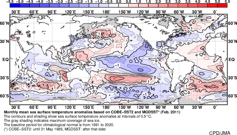
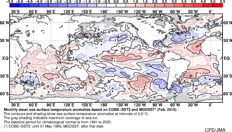
Go to this site to see for yourself:
https://ds.data.jma.go.jp/tcc/tcc/products/elnino/ocean/sst-ano-global_tcc.html
Simply click on the drop box in the top left corner where the year is and go back year after year and see for yourself.
Doing a reanalysis of the 500mb maps for Jan1st-Feb28th for both years 2010 & 2011 you get this. We haven't seen this 500mb look during these two months(Jan-Feb) for over a decade now.


Below is every other year since then starting with 2012-2023:


You can see that there werea few years where the mean 500mb patttern was trough in the east between Jan 2014-2016. This happens to be the only back to back El Nino years we have had, coming off back to back ENSO neutral years, since the last time the SSTA have been colder than normal off our SE coast. You actually have to go back as far as 86-87 & 87-88 the last time there was a back to back El Nino winters. https://ggweather.com/enso/oni.htm

So you ask what needs to change in order for this to flip. I think we need to see below normal SSTA off the SE coast AND GOM, (at least the SE coast), or inoder to prevent the SER/WAR from so easily flexing during our winters. I think we also need the AMO needs to flip also. As you can see by the image below the AMO has been warm, and much warmer than in the prev century and a quarter, for about 27/8 or so years +/-. On average the AMO spends about 30-40 years in either the warm or cold phases before flipping again. When, not if, it happens again I think we will see a major shift to earths thermostat. Esp if we really are headed into a solar minimum like many are predicting.

_________________
"In weather and in life, there's no winning and losing; there's only winning and learning."
WINTER 2012/2013 TOTALS 43.65"WINTER 2017/2018 TOTALS 62.85" WINTER 2022/2023 TOTALS 4.9"
WINTER 2013/2014 TOTALS 64.85"WINTER 2018/2019 TOTALS 14.25" WINTER 2023/2024 TOTALS 13.1"
WINTER 2014/2015 TOTALS 71.20"WINTER 2019/2020 TOTALS 6.35"
WINTER 2015/2016 TOTALS 35.00"WINTER 2020/2021 TOTALS 37.75"
WINTER 2016/2017 TOTALS 42.25"WINTER 2021/2022 TOTALS 31.65"
sroc4- Admin
- Posts : 8331
Reputation : 301
Join date : 2013-01-07
Location : Wading River, LI
heehaw453 likes this post
Re: March Obs & Discussions
![]() by docstox12 Sun Mar 19, 2023 6:00 am
by docstox12 Sun Mar 19, 2023 6:00 am
Perhaps CP can arrange for a massive air drop of ice cubes into the ocean off the SE coast this season to hasten this downtrend of the AMO.
docstox12- Wx Statistician Guru
- Posts : 8507
Reputation : 222
Join date : 2013-01-07
Age : 73
Location : Monroe NY
sroc4 and heehaw453 like this post
Re: March Obs & Discussions
![]() by heehaw453 Sun Mar 19, 2023 11:33 am
by heehaw453 Sun Mar 19, 2023 11:33 am
I see the foreseeable future as warming continuing and analogs that used to be relevant aren't anymore. I look no further than the NAM state in December as proof of that. I also see more extreme type of snowstorms occurring with the AN SST a la January 2016, however, there's a point when the base state warms so much that what used to be bread and butter setups don't work anymore and that affects the snowfall mean, periodicity of snow and snow depth longevity.
I agree with you the scale will tip back, but the question is when and how extreme are we going to get before that? I think we have some more of what we just went through to get to end of the tunnel unfortunately. And, I'm not saying we won't snow anymore, but don't be surprised if we see 2022/23 repeat itself in the near term with an even more extreme version if that's possible.
heehaw453- Advanced Forecaster
- Posts : 3906
Reputation : 86
Join date : 2014-01-20
Location : Bedminster Township, PA Elevation 600' ASL
Page 3 of 4 • 1, 2, 3, 4 ![]()
|
|
|