
 Search
Long Range Thread 25.0
Page 39 of 40 •  1 ... 21 ... 38, 39, 40
 ![]()
Re: Long Range Thread 25.0
![]() by amugs Tue Feb 28, 2023 10:47 am
by amugs Tue Feb 28, 2023 10:47 am
MJO goes sick mode in Phase 8. Where was this in Jan and Feb??


That is a very strong Phase 8 which would lead to a cold period and possible snowy timeframe if storms come about for our region. Nothing guaranteed but promising especially with wavelengths and past history of March storms.
If it can get into Phase 1 that is even better than 8 for March. It's like Phase 8 in Jan/Feb.
amugs- Advanced Forecaster - Mod

- Posts : 15093
Join date : 2013-01-07
Re: Long Range Thread 25.0
![]() by heehaw453 Tue Feb 28, 2023 1:24 pm
by heehaw453 Tue Feb 28, 2023 1:24 pm

heehaw453- Advanced Forecaster

- Posts : 3906
Join date : 2014-01-20
CPcantmeasuresnow likes this post
Re: Long Range Thread 25.0
![]() by amugs Tue Feb 28, 2023 1:58 pm
by amugs Tue Feb 28, 2023 1:58 pm
_________________
Mugs
AKA:King: Snow Weenie
Self Proclaimed
WINTER 2014-15 : 55.12" +.02 for 6 coatings (avg. 35")
WINTER 2015-16 Total - 29.8" (Avg 35")
WINTER 2016-17 : 39.5" so far

amugs- Advanced Forecaster - Mod
- Posts : 15093
Reputation : 213
Join date : 2013-01-07
Age : 54
Location : Hillsdale,NJ
Re: Long Range Thread 25.0
![]() by WeatherBob Tue Feb 28, 2023 2:03 pm
by WeatherBob Tue Feb 28, 2023 2:03 pm

WeatherBob- Meteorologist

- Posts : 683
Reputation : 83
Join date : 2013-12-13
Location : Caldwell, NJ - NW Essex County - Altitude 500 FT
docstox12, CPcantmeasuresnow, Radz, crippo84 and 1190ftalt like this post
Re: Long Range Thread 25.0
![]() by essexcountypete Tue Feb 28, 2023 4:15 pm
by essexcountypete Tue Feb 28, 2023 4:15 pm
WeatherBob wrote:Is that a Gulf Low with arctic air all over the US on the 384 hr? OMG , I can’t think of the last time we had a classic gulf nor’easter coming up the coast!!!
The "Ides of March" storm has a nice ring to it.

essexcountypete- Pro Enthusiast

- Posts : 783
Reputation : 12
Join date : 2013-12-09
Location : Bloomfield, NJ
Re: Long Range Thread 25.0
![]() by jmanley32 Tue Feb 28, 2023 5:25 pm
by jmanley32 Tue Feb 28, 2023 5:25 pm

jmanley32- Senior Enthusiast

- Posts : 20517
Reputation : 108
Join date : 2013-12-12
Age : 42
Location : Yonkers, NY
Re: Long Range Thread 25.0
![]() by amugs Tue Feb 28, 2023 7:20 pm
by amugs Tue Feb 28, 2023 7:20 pm

_________________
Mugs
AKA:King: Snow Weenie
Self Proclaimed
WINTER 2014-15 : 55.12" +.02 for 6 coatings (avg. 35")
WINTER 2015-16 Total - 29.8" (Avg 35")
WINTER 2016-17 : 39.5" so far
amugs- Advanced Forecaster - Mod
- Posts : 15093
Reputation : 213
Join date : 2013-01-07
Age : 54
Location : Hillsdale,NJ
Re: Long Range Thread 25.0
![]() by jmanley32 Wed Mar 01, 2023 2:38 am
by jmanley32 Wed Mar 01, 2023 2:38 am
00z looks promising, gets even a few inches into nyc, just north of there around 287 north sees 6+, wont take but a 25-50 mile push to give many a good snowfall, maybe better than yesterday.amugs wrote:What I tell ya about the confluence press and NAO like this last storm? Another 50 mile tick South is not out of realm, 100 miles would be incredible!! But that's fantasy. Keep ticking colder. HV may have to watch out for a prolong snow to ice event.
jmanley32- Senior Enthusiast
- Posts : 20517
Reputation : 108
Join date : 2013-12-12
Age : 42
Location : Yonkers, NY
Re: Long Range Thread 25.0
![]() by sroc4 Wed Mar 01, 2023 6:48 am
by sroc4 Wed Mar 01, 2023 6:48 am
jmanley32 wrote:00z looks promising, gets even a few inches into nyc, just north of there around 287 north sees 6+, wont take but a 25-50 mile push to give many a good snowfall, maybe better than yesterday.amugs wrote:What I tell ya about the confluence press and NAO like this last storm? Another 50 mile tick South is not out of realm, 100 miles would be incredible!! But that's fantasy. Keep ticking colder. HV may have to watch out for a prolong snow to ice event.
Which model are you looking at? I dont see any brining a few inches into NYC.
_________________
"In weather and in life, there's no winning and losing; there's only winning and learning."
WINTER 2012/2013 TOTALS 43.65"WINTER 2017/2018 TOTALS 62.85" WINTER 2022/2023 TOTALS 4.9"
WINTER 2013/2014 TOTALS 64.85"WINTER 2018/2019 TOTALS 14.25" WINTER 2023/2024 TOTALS 13.1"
WINTER 2014/2015 TOTALS 71.20"WINTER 2019/2020 TOTALS 6.35"
WINTER 2015/2016 TOTALS 35.00"WINTER 2020/2021 TOTALS 37.75"
WINTER 2016/2017 TOTALS 42.25"WINTER 2021/2022 TOTALS 31.65"

sroc4- Admin

- Posts : 8331
Reputation : 301
Join date : 2013-01-07
Location : Wading River, LI
Re: Long Range Thread 25.0
![]() by sroc4 Wed Mar 01, 2023 8:07 am
by sroc4 Wed Mar 01, 2023 8:07 am
The set up leading into this, ie Thursday into Friday, is almost a carbon copy of the snow event we had Monday into Tuesday. You have a potent shortwave that closes off to become an ULL as it crosses the panhandle of Texas; then heads into the Ohio valley and GL. However, there are significant differences as to wy this likely wont be the same or even similar outcome.
First, and Ive mentioned this yesterday too is the Trop forcing. While the SOI is weakly positive, it remains positive which gives a La Nina "background state" favoring the SE ridge. In addition, and much more importantly IMHO, the MJO is coming out with amplitude in phases 6-7 for his event which is a warm soln phase. This was not the case for Mondays event. OLR maps support this observation.
But you might think well we still have a robust -NAO and evidence of a 50/50 low that we also had for Mondays event. In reality it was these two features that forced our cutting ULL to open up, and tranfer its energy SOUTH of LI before gaining too much latitude. This allowed for CAD to do its dirty work and hang on.
BUT unfort this go round the 50/50 low IS NOT like it was. Look at the images below and pay particular attention to the areas circled. This is our 50/50. For Mondays set up notice just how robust the trough was. The deeper the colors the lower the heights. The lower the heights the more intense the cold air mass. Notice that with Fridays set up the strength of this block is half of what it was leading into Monday(First image is Mondays set up; second is Fridays). The X in the second image is a weakness in the block which combined with the MJO forcing mechanisms in the Pac allow the SE ridge to push harder and against less resistance, which allows the ULL to maintain its closed state and gain too much latitude before transferring its energy off the coast which pushes the warm air too far N.


If you zoom in a litttle notice the difference at which the angle of confluence is. In Mondays set up it was oriented much more NW to SE; where as Friday's is much more WNW to ESE. (aka less steep) The steepness of this confluence, the depth at which those heights are to the N&E of the confluence, and the weaker Pac forcing mechanisms for Monday is what forced our energy underneath. The more progressive angle of confluence, lack of depth and strength of the heights N&E of the confluence, and stronger MJO forcing mechanisms for late week set up is why I do not believe that most of us achieve success. That said one's definition of success needs to be defined I suppose. Expect maybe a few wet non accumulating flakes and a quick transition to sleet; then rain along the coastal plain, and maybe a slushy few inches of snow before transitioning to sleet and eventually rain as well N&W. Thats just how I see it now. Ill gladly eat crow if this thing conts to trend but I would argue we all should temper expectations.


_________________
"In weather and in life, there's no winning and losing; there's only winning and learning."
WINTER 2012/2013 TOTALS 43.65"WINTER 2017/2018 TOTALS 62.85" WINTER 2022/2023 TOTALS 4.9"
WINTER 2013/2014 TOTALS 64.85"WINTER 2018/2019 TOTALS 14.25" WINTER 2023/2024 TOTALS 13.1"
WINTER 2014/2015 TOTALS 71.20"WINTER 2019/2020 TOTALS 6.35"
WINTER 2015/2016 TOTALS 35.00"WINTER 2020/2021 TOTALS 37.75"
WINTER 2016/2017 TOTALS 42.25"WINTER 2021/2022 TOTALS 31.65"
sroc4- Admin
- Posts : 8331
Reputation : 301
Join date : 2013-01-07
Location : Wading River, LI
essexcountypete, jmanley32, heehaw453 and JT33 like this post
Re: Long Range Thread 25.0
![]() by JT33 Wed Mar 01, 2023 8:40 am
by JT33 Wed Mar 01, 2023 8:40 am
JT33- Posts : 42
Reputation : 0
Join date : 2022-01-25
Location : Piscataway
sroc4, SENJsnowman and MattyICE like this post
Re: Long Range Thread 25.0
![]() by jmanley32 Wed Mar 01, 2023 8:43 am
by jmanley32 Wed Mar 01, 2023 8:43 am
the 00z gfs gave me a little snow, so not exactly nyc, 15 miles north, look at the snow map it just barely makes it down, i was sayiing if this pushed the cold further south we could see a decent snow it doesn't look like it would take a lot, havent read your writeup yet.sroc4 wrote:jmanley32 wrote:00z looks promising, gets even a few inches into nyc, just north of there around 287 north sees 6+, wont take but a 25-50 mile push to give many a good snowfall, maybe better than yesterday.amugs wrote:What I tell ya about the confluence press and NAO like this last storm? Another 50 mile tick South is not out of realm, 100 miles would be incredible!! But that's fantasy. Keep ticking colder. HV may have to watch out for a prolong snow to ice event.
Which model are you looking at? I dont see any brining a few inches into NYC.
jmanley32- Senior Enthusiast
- Posts : 20517
Reputation : 108
Join date : 2013-12-12
Age : 42
Location : Yonkers, NY
sroc4 likes this post
Re: Long Range Thread 25.0
![]() by jmanley32 Wed Mar 01, 2023 8:47 am
by jmanley32 Wed Mar 01, 2023 8:47 am
jmanley32- Senior Enthusiast
- Posts : 20517
Reputation : 108
Join date : 2013-12-12
Age : 42
Location : Yonkers, NY
Re: Long Range Thread 25.0
![]() by docstox12 Wed Mar 01, 2023 8:51 am
by docstox12 Wed Mar 01, 2023 8:51 am

docstox12- Wx Statistician Guru

- Posts : 8507
Reputation : 222
Join date : 2013-01-07
Age : 73
Location : Monroe NY
Re: Long Range Thread 25.0
![]() by billg315 Wed Mar 01, 2023 9:22 am
by billg315 Wed Mar 01, 2023 9:22 am
I'll see how the model runs today look before making a final judgement as sometimes certain trends repeat themselves so one wonders if this will trend slightly south/colder over the next 48 hours as the last storm did. Although sroc posts some good logic for why it might not.

billg315- Advanced Forecaster - Mod
- Posts : 4469
Reputation : 185
Join date : 2015-01-24
Age : 50
Location : Flemington, NJ
1190ftalt likes this post
Re: Long Range Thread 25.0
![]() by billg315 Wed Mar 01, 2023 9:28 am
by billg315 Wed Mar 01, 2023 9:28 am
billg315- Advanced Forecaster - Mod
- Posts : 4469
Reputation : 185
Join date : 2015-01-24
Age : 50
Location : Flemington, NJ
Re: Long Range Thread 25.0
![]() by CPcantmeasuresnow Wed Mar 01, 2023 9:51 am
by CPcantmeasuresnow Wed Mar 01, 2023 9:51 am
docstox12 wrote:NWS has a slop storm up here, 1 to 3 inches ATM.
But point and click has 5-8 and we know how accurate that is.

CPcantmeasuresnow- Wx Statistician Guru
- Posts : 7274
Reputation : 230
Join date : 2013-01-07
Age : 103
Location : Eastern Orange County, NY
Re: Long Range Thread 25.0
![]() by amugs Wed Mar 01, 2023 10:16 am
by amugs Wed Mar 01, 2023 10:16 am


_________________
Mugs
AKA:King: Snow Weenie
Self Proclaimed
WINTER 2014-15 : 55.12" +.02 for 6 coatings (avg. 35")
WINTER 2015-16 Total - 29.8" (Avg 35")
WINTER 2016-17 : 39.5" so far
amugs- Advanced Forecaster - Mod
- Posts : 15093
Reputation : 213
Join date : 2013-01-07
Age : 54
Location : Hillsdale,NJ
Re: Long Range Thread 25.0
![]() by amugs Wed Mar 01, 2023 10:32 am
by amugs Wed Mar 01, 2023 10:32 am


_________________
Mugs
AKA:King: Snow Weenie
Self Proclaimed
WINTER 2014-15 : 55.12" +.02 for 6 coatings (avg. 35")
WINTER 2015-16 Total - 29.8" (Avg 35")
WINTER 2016-17 : 39.5" so far
amugs- Advanced Forecaster - Mod
- Posts : 15093
Reputation : 213
Join date : 2013-01-07
Age : 54
Location : Hillsdale,NJ
Re: Long Range Thread 25.0
![]() by heehaw453 Wed Mar 01, 2023 10:36 am
by heehaw453 Wed Mar 01, 2023 10:36 am
If you are NEPA, your area and NW NJ there is a potential for several inches of snow. I wouldn't sleep on this system just yet. Subtle changes will have large impacts on warm intrusion. I'm mostly concerned about the 700mb L.CPcantmeasuresnow wrote:docstox12 wrote:NWS has a slop storm up here, 1 to 3 inches ATM.
But point and click has 5-8 and we know how accurate that is.
heehaw453- Advanced Forecaster
- Posts : 3906
Reputation : 86
Join date : 2014-01-20
Location : Bedminster Township, PA Elevation 600' ASL
1190ftalt likes this post
Re: Long Range Thread 25.0
![]() by sroc4 Wed Mar 01, 2023 10:37 am
by sroc4 Wed Mar 01, 2023 10:37 am
CPcantmeasuresnow wrote:docstox12 wrote:NWS has a slop storm up here, 1 to 3 inches ATM.
But point and click has 5-8 and we know how accurate that is.
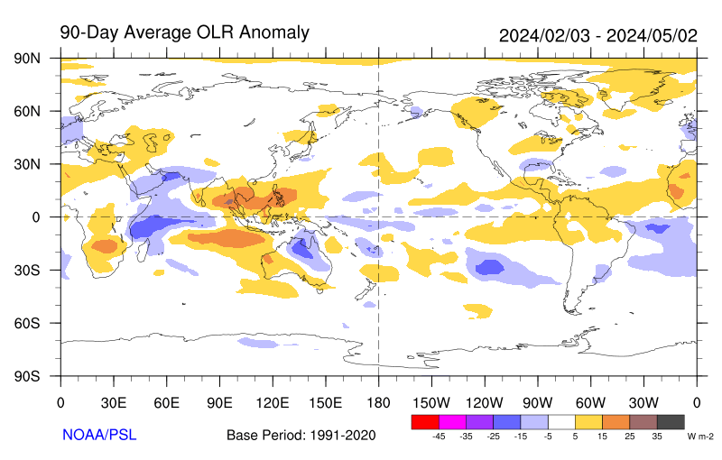
The moderate La Nina for three consecutive winters combined with a warm SSTA in the area around the Philippines and Indonesia and cool central IO caused the best forcing to occur over the MJO regions of 3-6. The 90day seasonal OLR says it all(purple over the Philippines and Indonesia). But the trop Pac and IO SSTA, they are a shifting. ENSO regions are slowly warming. Western Indonesia is cooling and IO is moderating. This is what is allowing the rising and sinking patterns along the equator, aka Walker cell configuration) to shift to one of an MJO phase coming out in 6-7 but making it east into 8-1 potentially.


_________________
"In weather and in life, there's no winning and losing; there's only winning and learning."
WINTER 2012/2013 TOTALS 43.65"WINTER 2017/2018 TOTALS 62.85" WINTER 2022/2023 TOTALS 4.9"
WINTER 2013/2014 TOTALS 64.85"WINTER 2018/2019 TOTALS 14.25" WINTER 2023/2024 TOTALS 13.1"
WINTER 2014/2015 TOTALS 71.20"WINTER 2019/2020 TOTALS 6.35"
WINTER 2015/2016 TOTALS 35.00"WINTER 2020/2021 TOTALS 37.75"
WINTER 2016/2017 TOTALS 42.25"WINTER 2021/2022 TOTALS 31.65"
sroc4- Admin
- Posts : 8331
Reputation : 301
Join date : 2013-01-07
Location : Wading River, LI
JT33 likes this post
Re: Long Range Thread 25.0
![]() by jmanley32 Wed Mar 01, 2023 12:41 pm
by jmanley32 Wed Mar 01, 2023 12:41 pm
No solid snow for anyone on that map, i like to see how far south it is, at least maybe IMBY I get to see something, even if it doesn't stick. It is still very pretty to watch. Does this impact Thursday night like 8:30-11pm or Saturday say midday at all? We are taking atrip up to eastern CT on late Thursday night and returning midday early afternoon Sat. But I do not want to be fdriving in ice and I know CT I-95 often sees more than around here.amugs wrote:Friday siding with CMC and GFS I guess
jmanley32- Senior Enthusiast
- Posts : 20517
Reputation : 108
Join date : 2013-12-12
Age : 42
Location : Yonkers, NY
Re: Long Range Thread 25.0
![]() by amugs Wed Mar 01, 2023 1:10 pm
by amugs Wed Mar 01, 2023 1:10 pm

Nothing compare to March 2018, like 1995-96 winter at this time.
Will it ever happen again... it shall weather loves to repeat itself somehow someway but maybe 10-15 or 25 years from now but it will. Maybe not textbook but similar. I'd say.
_________________
Mugs
AKA:King: Snow Weenie
Self Proclaimed
WINTER 2014-15 : 55.12" +.02 for 6 coatings (avg. 35")
WINTER 2015-16 Total - 29.8" (Avg 35")
WINTER 2016-17 : 39.5" so far
amugs- Advanced Forecaster - Mod
- Posts : 15093
Reputation : 213
Join date : 2013-01-07
Age : 54
Location : Hillsdale,NJ
phil155 likes this post
Re: Long Range Thread 25.0
![]() by heehaw453 Wed Mar 01, 2023 2:03 pm
by heehaw453 Wed Mar 01, 2023 2:03 pm

heehaw453- Advanced Forecaster
- Posts : 3906
Reputation : 86
Join date : 2014-01-20
Location : Bedminster Township, PA Elevation 600' ASL
CPcantmeasuresnow likes this post
Re: Long Range Thread 25.0
![]() by amugs Wed Mar 01, 2023 4:33 pm
by amugs Wed Mar 01, 2023 4:33 pm

_________________
Mugs
AKA:King: Snow Weenie
Self Proclaimed
WINTER 2014-15 : 55.12" +.02 for 6 coatings (avg. 35")
WINTER 2015-16 Total - 29.8" (Avg 35")
WINTER 2016-17 : 39.5" so far
amugs- Advanced Forecaster - Mod
- Posts : 15093
Reputation : 213
Join date : 2013-01-07
Age : 54
Location : Hillsdale,NJ
Re: Long Range Thread 25.0
![]() by amugs Wed Mar 01, 2023 4:36 pm
by amugs Wed Mar 01, 2023 4:36 pm

_________________
Mugs
AKA:King: Snow Weenie
Self Proclaimed
WINTER 2014-15 : 55.12" +.02 for 6 coatings (avg. 35")
WINTER 2015-16 Total - 29.8" (Avg 35")
WINTER 2016-17 : 39.5" so far
amugs- Advanced Forecaster - Mod
- Posts : 15093
Reputation : 213
Join date : 2013-01-07
Age : 54
Location : Hillsdale,NJ
Re: Long Range Thread 25.0
![]() by SENJsnowman Wed Mar 01, 2023 4:54 pm
by SENJsnowman Wed Mar 01, 2023 4:54 pm
heehaw453 wrote:During March 2018 I had over 1' by March 13. How long does the SER take to get beaten down? Here is March 2018 during first 10 days. Clearly we didn't have the SER problem we have with this pattern and had neutral PNA. This tells me it's after 3/10 and anywhere on the coastal plain it's really fighting climo. Think maybe 10 window to score something, but it ain't going to be easy.
Yep, the coast fights climo big time after March 10- especially the southern coastal plain. Like I mentioned a few weeks ago, the unshakeable micro-trend for the Shore this season has been to be summarily dismissed from any all threats at the onset. So, realistically, down here we are probably <10% to really partake in any mid-late March rewards. But you know me...
Ironically enough, it was the 4th and final storm in that March 2018 pattern that finally brought the goods to the Jersey Shore, the coastal plain of all coastal plains! That storm was either on the first or second day of spring, approximately March 18 or even March 20. And due to a heavy N Atlantic block, Ocean County got 13" in like 6 hours* because after an hour or two of the storm grinding over the top of us, the column cooled drastically and quickly. And the pending conditions do seem to be reminiscent of March 2018. MJO 8-1 and a block, right? Better to go into the final stretch with that combo of conditions anyway, hopefully at least make interesting for us southern coasties.
And Mugs, you started calling this exact pattern change WEEKS ago! Well done- again.
*omg, what a moment that was! After 2 days of chilling rain and AFTER the canceled school day had already ended, the heavens opened up and the frozen manna just would not stop! And several loud claps of thunder! We all just sat in the living room and watched in awe and amazement as God and nature just went to town!!!
SENJsnowman- Senior Enthusiast
- Posts : 1186
Reputation : 61
Join date : 2017-01-06
Age : 51
Location : Bayville, NJ
docstox12, 1190ftalt and heehaw453 like this post
Page 39 of 40 • 1 ... 21 ... 38, 39, 40 ![]()
|
|
|