
 Search
March 12 2022 Strong and Fast Moving Storm - Winter's last stand for interior?
Page 1 of 8 • 1, 2, 3, 4, 5, 6, 7, 8 ![]()

March 12 2022 Strong and Fast Moving Storm - Winter's last stand for interior?
![]() by heehaw453 Thu Mar 10, 2022 9:55 am
by heehaw453 Thu Mar 10, 2022 9:55 am
- Strong Miller A's in March more often than not will pull closer to the coast than modelled. Especially w/out any west based blocking to inhibit that.
- The antecedent air mass is bad. No it's really bad so much so that the SE ridge does it's dirty work all the way up to ME
- The storm is a really fast mover mostly due to point 1.
These things taken together are too much to overcome for any meaningful for most of the area IMO.
I'd say I-95 and points SE not much of anything
NW of I-95 within 40 miles maybe a c-1"
Well NW of I-95 maybe an 1-2"
I-81 corridor from Scranton to Binghamton has the best shot of 3-6"
Elevated areas > 1500' in NEPA/NW NJ/Sullivan or Delaware Counties 3-5". That extra elevation will allow for a quick paste.
We shall see and good luck to all!
heehaw453- Advanced Forecaster

- Posts : 3906
Reputation : 86
Join date : 2014-01-20
Location : Bedminster Township, PA Elevation 600' ASL
Re: March 12 2022 Strong and Fast Moving Storm - Winter's last stand for interior?
![]() by heehaw453 Thu Mar 10, 2022 10:24 am
by heehaw453 Thu Mar 10, 2022 10:24 am


heehaw453- Advanced Forecaster
- Posts : 3906
Reputation : 86
Join date : 2014-01-20
Location : Bedminster Township, PA Elevation 600' ASL
Re: March 12 2022 Strong and Fast Moving Storm - Winter's last stand for interior?
![]() by dkodgis Thu Mar 10, 2022 10:25 am
by dkodgis Thu Mar 10, 2022 10:25 am

dkodgis- Senior Enthusiast

- Posts : 2506
Reputation : 98
Join date : 2013-12-29
Re: March 12 2022 Strong and Fast Moving Storm - Winter's last stand for interior?
![]() by hyde345 Thu Mar 10, 2022 10:31 am
by hyde345 Thu Mar 10, 2022 10:31 am

hyde345- Pro Enthusiast

- Posts : 1082
Reputation : 48
Join date : 2013-01-08
Location : Hyde Park, NY
Re: March 12 2022 Strong and Fast Moving Storm - Winter's last stand for interior?
![]() by sroc4 Thu Mar 10, 2022 10:42 am
by sroc4 Thu Mar 10, 2022 10:42 am
heehaw453 wrote:Euro in general IMO is wrong with this system. It's about the synoptics which IMO are pretty much set now that we are within 60 hours.
- Strong Miller A's in March more often than not will pull closer to the coast than modelled. Especially w/out any west based blocking to inhibit that.
- The antecedent air mass is bad. No it's really bad so much so that the SE ridge does it's dirty work all the way up to ME
- The storm is a really fast mover mostly due to point 1.
These things taken together are too much to overcome for any meaningful for most of the area IMO.
I'd say I-95 and points SE not much of anything
NW of I-95 within 40 miles maybe a c-1"
Well NW of I-95 maybe an 1-2"
I-81 corridor from Scranton to Binghamton has the best shot of 3-6"
Elevated areas > 1500' in NEPA/NW NJ/Sullivan or Delaware Counties 3-5". That extra elevation will allow for a quick paste.
We shall see and good luck to all!
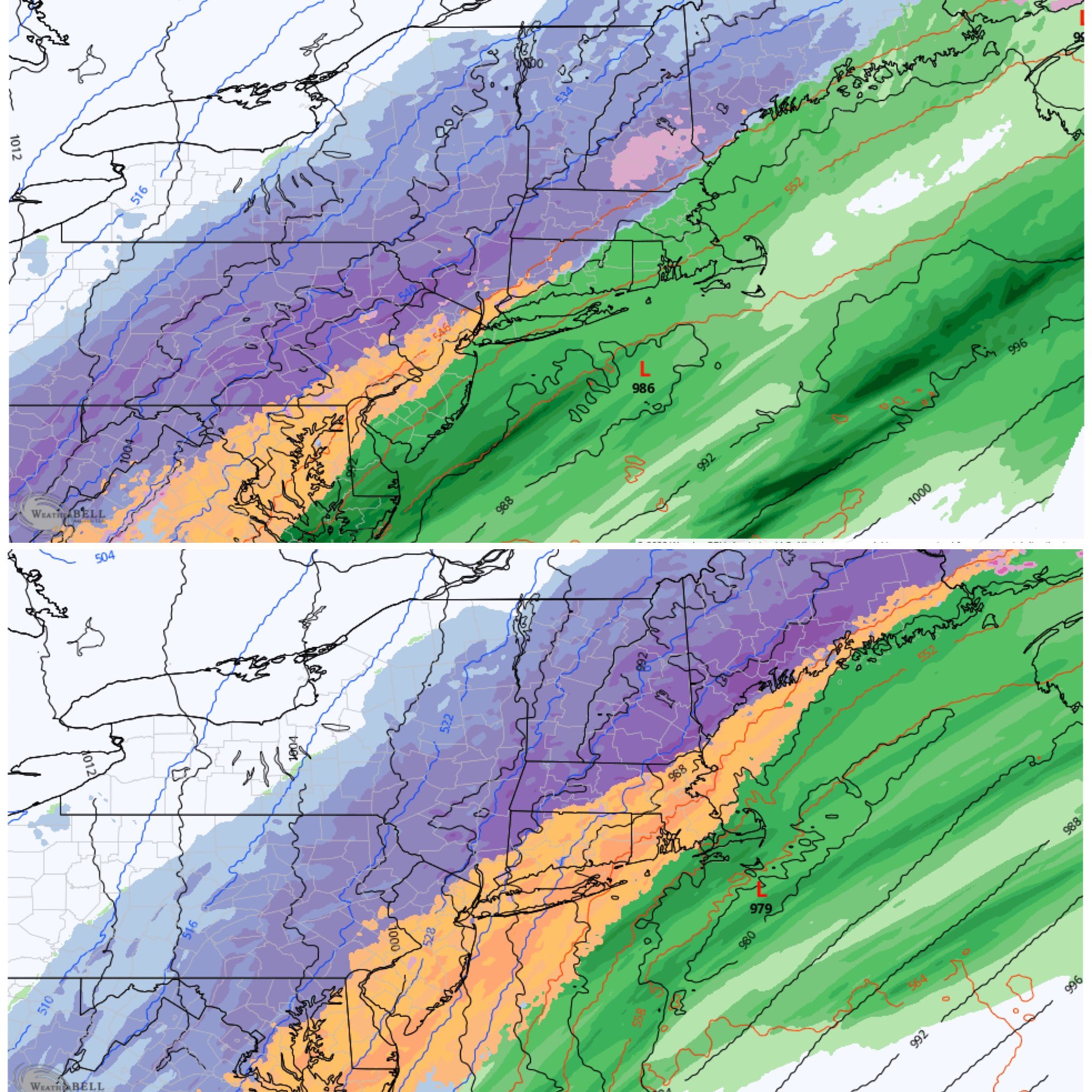
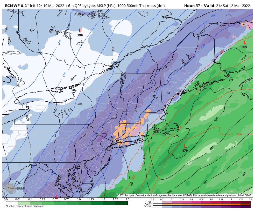
Euro conts to insist moving the low east and places the ccB right over us. This storm is deepening fast so mid levels crash pretty quickly. Back end snow is hard to come by but not unprecedented in these parts. Obv the further west you go the better chance. If the placement of the ccB is correct it may thump fast and furious as the slp passes us to the North and east.
If you look west Heehaw there are two things that may lend credence to the eastern soln. First is the pna ridge. It’s axis of over Nevada would allow for that eastern more soln. Going to have to watch that. Second is the energy crashing the W coast near Canada CONUs. This progressive Atlantic and Pac pattern tells me it will likely continue to push the entire mean trough complex along. This problem, energy crashing the west coast, has been a theme all winter so no reason to believe it won’t be a factor this time. In this situation it may lend a helping rather than hurting hand it pushing the entire this further east as we get in right if the timing is right.
Final comment about the crashing mid levels. If back end snow is going to work it happens very rapidly making even 48-60 hrs out too far out to really see it in some of the lower resultion models or in the LR of the short range models. Watching the NAM srat trending colder and euro walking its self east over the past day or two makes stop and think. Those rapidly changing dynamics as the slp is east and N will likley need the shorter range and higher resolution models like the euro to see it.
I’m actually thinking the colder solns make more sense at the moment but just how far S&E will it thump? I am not ruling out most if not all of LI to see something
_________________
"In weather and in life, there's no winning and losing; there's only winning and learning."
WINTER 2012/2013 TOTALS 43.65"WINTER 2017/2018 TOTALS 62.85" WINTER 2022/2023 TOTALS 4.9"
WINTER 2013/2014 TOTALS 64.85"WINTER 2018/2019 TOTALS 14.25" WINTER 2023/2024 TOTALS 13.1"
WINTER 2014/2015 TOTALS 71.20"WINTER 2019/2020 TOTALS 6.35"
WINTER 2015/2016 TOTALS 35.00"WINTER 2020/2021 TOTALS 37.75"
WINTER 2016/2017 TOTALS 42.25"WINTER 2021/2022 TOTALS 31.65"

sroc4- Admin

- Posts : 8331
Reputation : 301
Join date : 2013-01-07
Location : Wading River, LI
hyde345 likes this post
Re: March 12 2022 Strong and Fast Moving Storm - Winter's last stand for interior?
![]() by sroc4 Thu Mar 10, 2022 11:24 am
by sroc4 Thu Mar 10, 2022 11:24 am
_________________
"In weather and in life, there's no winning and losing; there's only winning and learning."
WINTER 2012/2013 TOTALS 43.65"WINTER 2017/2018 TOTALS 62.85" WINTER 2022/2023 TOTALS 4.9"
WINTER 2013/2014 TOTALS 64.85"WINTER 2018/2019 TOTALS 14.25" WINTER 2023/2024 TOTALS 13.1"
WINTER 2014/2015 TOTALS 71.20"WINTER 2019/2020 TOTALS 6.35"
WINTER 2015/2016 TOTALS 35.00"WINTER 2020/2021 TOTALS 37.75"
WINTER 2016/2017 TOTALS 42.25"WINTER 2021/2022 TOTALS 31.65"
sroc4- Admin
- Posts : 8331
Reputation : 301
Join date : 2013-01-07
Location : Wading River, LI
Re: March 12 2022 Strong and Fast Moving Storm - Winter's last stand for interior?
![]() by heehaw453 Thu Mar 10, 2022 11:32 am
by heehaw453 Thu Mar 10, 2022 11:32 am
heehaw453- Advanced Forecaster
- Posts : 3906
Reputation : 86
Join date : 2014-01-20
Location : Bedminster Township, PA Elevation 600' ASL
Re: March 12 2022 Strong and Fast Moving Storm - Winter's last stand for interior?
![]() by hyde345 Thu Mar 10, 2022 11:37 am
by hyde345 Thu Mar 10, 2022 11:37 am
sroc4 wrote:IMO GFS cant handle the dynamics of this sytem
Can it handle dynamics of any system? LOL. BTW12z CMC is well east of 00z.
hyde345- Pro Enthusiast
- Posts : 1082
Reputation : 48
Join date : 2013-01-08
Location : Hyde Park, NY
Re: March 12 2022 Strong and Fast Moving Storm - Winter's last stand for interior?
![]() by SENJsnowman Thu Mar 10, 2022 11:44 am
by SENJsnowman Thu Mar 10, 2022 11:44 am
sroc4 wrote:heehaw453 wrote:Euro in general IMO is wrong with this system. It's about the synoptics which IMO are pretty much set now that we are within 60 hours.
- Strong Miller A's in March more often than not will pull closer to the coast than modelled. Especially w/out any west based blocking to inhibit that.
- The antecedent air mass is bad. No it's really bad so much so that the SE ridge does it's dirty work all the way up to ME
- The storm is a really fast mover mostly due to point 1.
These things taken together are too much to overcome for any meaningful for most of the area IMO.
I'd say I-95 and points SE not much of anything
NW of I-95 within 40 miles maybe a c-1"
Well NW of I-95 maybe an 1-2"
I-81 corridor from Scranton to Binghamton has the best shot of 3-6"
Elevated areas > 1500' in NEPA/NW NJ/Sullivan or Delaware Counties 3-5". That extra elevation will allow for a quick paste.
We shall see and good luck to all!
Euro conts to insist moving the low east and places the ccB right over us. This storm is deepening fast so mid levels crash pretty quickly. Back end snow is hard to come by but not unprecedented in these parts. Obv the further west you go the better chance. If the placement of the ccB is correct it may thump fast and furious as the slp passes us to the North and east.
If you look west Heehaw there are two things that may lend credence to the eastern soln. First is the pna ridge. It’s axis of over Nevada would allow for that eastern more soln. Going to have to watch that. Second is the energy crashing the W coast near Canada CONUs. This progressive Atlantic and Pac pattern tells me it will likely continue to push the entire mean trough complex along. This problem, energy crashing the west coast, has been a theme all winter so no reason to believe it won’t be a factor this time. In this situation it may lend a helping rather than hurting hand it pushing the entire this further east as we get in right if the timing is right.
Final comment about the crashing mid levels. If back end snow is going to work it happens very rapidly making even 48-60 hrs out too far out to really see it in some of the lower resultion models or in the LR of the short range models. Watching the NAM srat trending colder and euro walking its self east over the past day or two makes stop and think. Those rapidly changing dynamics as the slp is east and N will likley need the shorter range and higher resolution models like the euro to see it.
I’m actually thinking the colder solns make more sense at the moment but just how far S&E will it thump? I am not ruling out most if not all of LI to see something
So, is it fair to say the goalposts are framed b/w heehaw's and sroc's observations? As far as the coastal plain of the Jersey Shore, we know it's at best a long shot to get any accumulating snow down here. But, if you consider the portions I bolded in srocs post above- it sounds identical to where we stood March 19 (or so), 2018. Two days before we caught 13" in coastal Ocean County. It was in the 60's on March 20 and in the 50s for much of March 21, 2018 before those mid levels crashed like never before and it became an official blizzard and a prolific thundersnow storm!
Thus, even down here at the Shore...we track!
SENJsnowman- Senior Enthusiast
- Posts : 1186
Reputation : 61
Join date : 2017-01-06
Age : 51
Location : Bayville, NJ
Re: March 12 2022 Strong and Fast Moving Storm - Winter's last stand for interior?
![]() by sroc4 Thu Mar 10, 2022 12:06 pm
by sroc4 Thu Mar 10, 2022 12:06 pm
heehaw453 wrote:I would be so into this threat with a good dome of cold air to start with. Easy 6-12" even with the well inside BM track.
100% Haw. Unfort This is one of those storms that will have to generate its own cold air. Dropping from 1000mb into the low 980's or even 970's in 12 hrs has the potential to do it. But obv the chances to work out IMBY are not the same as if we had a Miller A headed straight into a 1040mb dome of arctic air. But again not unprecedented. IMBY specifically I am the least likely to benefit from this set up.
_________________
"In weather and in life, there's no winning and losing; there's only winning and learning."
WINTER 2012/2013 TOTALS 43.65"WINTER 2017/2018 TOTALS 62.85" WINTER 2022/2023 TOTALS 4.9"
WINTER 2013/2014 TOTALS 64.85"WINTER 2018/2019 TOTALS 14.25" WINTER 2023/2024 TOTALS 13.1"
WINTER 2014/2015 TOTALS 71.20"WINTER 2019/2020 TOTALS 6.35"
WINTER 2015/2016 TOTALS 35.00"WINTER 2020/2021 TOTALS 37.75"
WINTER 2016/2017 TOTALS 42.25"WINTER 2021/2022 TOTALS 31.65"
sroc4- Admin
- Posts : 8331
Reputation : 301
Join date : 2013-01-07
Location : Wading River, LI
Re: March 12 2022 Strong and Fast Moving Storm - Winter's last stand for interior?
![]() by amugs Thu Mar 10, 2022 12:54 pm
by amugs Thu Mar 10, 2022 12:54 pm
sroc4 wrote:heehaw453 wrote:I would be so into this threat with a good dome of cold air to start with. Easy 6-12" even with the well inside BM track.
100% Haw. Unfort This is one of those storms that will have to generate its own cold air. Dropping from 1000mb into the low 980's or even 970's in 12 hrs has the potential to do it. But obv the chances to work out IMBY are not the same as if we had a Miller A headed straight into a 1040mb dome of arctic air. But again not unprecedented. IMBY specifically I am the least likely to benefit from this set up.
Absolutely reminiscent of the 2002 Xmas storm that pulled arctic air that is sitting up overhead and crashed hard around here. NEVER throw out a solution in March due to teh variability of the clash of the airmasses I have learned.
12Z Hi Res NAM says buckle up folks!!!!
2PM top and
7PM bottom
Eweather off Twitter made this map
_________________
Mugs
AKA:King: Snow Weenie
Self Proclaimed
WINTER 2014-15 : 55.12" +.02 for 6 coatings (avg. 35")
WINTER 2015-16 Total - 29.8" (Avg 35")
WINTER 2016-17 : 39.5" so far

amugs- Advanced Forecaster - Mod

- Posts : 15093
Reputation : 213
Join date : 2013-01-07
Age : 54
Location : Hillsdale,NJ
Re: March 12 2022 Strong and Fast Moving Storm - Winter's last stand for interior?
![]() by phil155 Thu Mar 10, 2022 1:05 pm
by phil155 Thu Mar 10, 2022 1:05 pm
phil155- Pro Enthusiast
- Posts : 475
Reputation : 4
Join date : 2019-12-16
Re: March 12 2022 Strong and Fast Moving Storm - Winter's last stand for interior?
![]() by amugs Thu Mar 10, 2022 1:22 pm
by amugs Thu Mar 10, 2022 1:22 pm
_________________
Mugs
AKA:King: Snow Weenie
Self Proclaimed
WINTER 2014-15 : 55.12" +.02 for 6 coatings (avg. 35")
WINTER 2015-16 Total - 29.8" (Avg 35")
WINTER 2016-17 : 39.5" so far
amugs- Advanced Forecaster - Mod
- Posts : 15093
Reputation : 213
Join date : 2013-01-07
Age : 54
Location : Hillsdale,NJ
Re: March 12 2022 Strong and Fast Moving Storm - Winter's last stand for interior?
![]() by heehaw453 Thu Mar 10, 2022 1:25 pm
by heehaw453 Thu Mar 10, 2022 1:25 pm

heehaw453- Advanced Forecaster
- Posts : 3906
Reputation : 86
Join date : 2014-01-20
Location : Bedminster Township, PA Elevation 600' ASL
Snow88 likes this post
Re: March 12 2022 Strong and Fast Moving Storm - Winter's last stand for interior?
![]() by sroc4 Thu Mar 10, 2022 2:01 pm
by sroc4 Thu Mar 10, 2022 2:01 pm
As the loop starts notice a decent PNA ridge, but as the two pieces of energy come together and the trough approaches the EC the energy coming ashore SW Canada dives into the N Central Plains into the GL's combined with the energy coming onshore in the NW CONUS at the end of the loop act to push the entire trough complex along.

_________________
"In weather and in life, there's no winning and losing; there's only winning and learning."
WINTER 2012/2013 TOTALS 43.65"WINTER 2017/2018 TOTALS 62.85" WINTER 2022/2023 TOTALS 4.9"
WINTER 2013/2014 TOTALS 64.85"WINTER 2018/2019 TOTALS 14.25" WINTER 2023/2024 TOTALS 13.1"
WINTER 2014/2015 TOTALS 71.20"WINTER 2019/2020 TOTALS 6.35"
WINTER 2015/2016 TOTALS 35.00"WINTER 2020/2021 TOTALS 37.75"
WINTER 2016/2017 TOTALS 42.25"WINTER 2021/2022 TOTALS 31.65"
sroc4- Admin
- Posts : 8331
Reputation : 301
Join date : 2013-01-07
Location : Wading River, LI
Re: March 12 2022 Strong and Fast Moving Storm - Winter's last stand for interior?
![]() by SENJsnowman Thu Mar 10, 2022 2:17 pm
by SENJsnowman Thu Mar 10, 2022 2:17 pm
sroc4 wrote:I firmly believe its the timing of the energy crashing the west coast that is driving the eastern trend. This energy is moving things along. In the end this may end up leading to a colder soln but we lose the higher totals as the trough remains more progressive/positive tlted for longer. The enrgy involved is still strong so we get a deepining low that ends up in the 980's at least but surface reflection shos a more elongated slp rather than a tight circular slp.
As the loop starts notice a decent PNA ridge, but as the two pieces of energy come together and the trough approaches the EC the energy coming ashore SW Canada dives into the N Central Plains into the GL's combined with the energy coming onshore in the NW CONUS at the end of the loop act to push the entire trough complex along.
Great explanation/play by play! Wow, you can really see how that red swirl just hammers out those black lines from a sharp NW-SE flow to almost a due W-E flow.
At this point, I'm not even into heavy accumulations imby, but it would still be great to get one more parting shot of a few hours of some nice snowfall...
SENJsnowman- Senior Enthusiast
- Posts : 1186
Reputation : 61
Join date : 2017-01-06
Age : 51
Location : Bayville, NJ
Re: March 12 2022 Strong and Fast Moving Storm - Winter's last stand for interior?
![]() by dkodgis Thu Mar 10, 2022 2:26 pm
by dkodgis Thu Mar 10, 2022 2:26 pm
dkodgis- Senior Enthusiast
- Posts : 2506
Reputation : 98
Join date : 2013-12-29
Re: March 12 2022 Strong and Fast Moving Storm - Winter's last stand for interior?
![]() by heehaw453 Thu Mar 10, 2022 2:38 pm
by heehaw453 Thu Mar 10, 2022 2:38 pm
dkodgis wrote:This may be close to the last if not the last chance for snow. The temps are warming up by Monday for a week. Let us hope Sat’s storm gives us something.
dkodgis very high probability this be it my friend. Let's hope it can give some goodness even if it's a little.
heehaw453- Advanced Forecaster
- Posts : 3906
Reputation : 86
Join date : 2014-01-20
Location : Bedminster Township, PA Elevation 600' ASL
Re: March 12 2022 Strong and Fast Moving Storm - Winter's last stand for interior?
![]() by heehaw453 Thu Mar 10, 2022 3:07 pm
by heehaw453 Thu Mar 10, 2022 3:07 pm
SENJsnowman wrote:sroc4 wrote:heehaw453 wrote:Euro in general IMO is wrong with this system. It's about the synoptics which IMO are pretty much set now that we are within 60 hours.
- Strong Miller A's in March more often than not will pull closer to the coast than modelled. Especially w/out any west based blocking to inhibit that.
- The antecedent air mass is bad. No it's really bad so much so that the SE ridge does it's dirty work all the way up to ME
- The storm is a really fast mover mostly due to point 1.
These things taken together are too much to overcome for any meaningful for most of the area IMO.
I'd say I-95 and points SE not much of anything
NW of I-95 within 40 miles maybe a c-1"
Well NW of I-95 maybe an 1-2"
I-81 corridor from Scranton to Binghamton has the best shot of 3-6"
Elevated areas > 1500' in NEPA/NW NJ/Sullivan or Delaware Counties 3-5". That extra elevation will allow for a quick paste.
We shall see and good luck to all!
Euro conts to insist moving the low east and places the ccB right over us. This storm is deepening fast so mid levels crash pretty quickly. Back end snow is hard to come by but not unprecedented in these parts. Obv the further west you go the better chance. If the placement of the ccB is correct it may thump fast and furious as the slp passes us to the North and east.
If you look west Heehaw there are two things that may lend credence to the eastern soln. First is the pna ridge. It’s axis of over Nevada would allow for that eastern more soln. Going to have to watch that. Second is the energy crashing the W coast near Canada CONUs. This progressive Atlantic and Pac pattern tells me it will likely continue to push the entire mean trough complex along. This problem, energy crashing the west coast, has been a theme all winter so no reason to believe it won’t be a factor this time. In this situation it may lend a helping rather than hurting hand it pushing the entire this further east as we get in right if the timing is right.
Final comment about the crashing mid levels. If back end snow is going to work it happens very rapidly making even 48-60 hrs out too far out to really see it in some of the lower resultion models or in the LR of the short range models. Watching the NAM srat trending colder and euro walking its self east over the past day or two makes stop and think. Those rapidly changing dynamics as the slp is east and N will likley need the shorter range and higher resolution models like the euro to see it.
I’m actually thinking the colder solns make more sense at the moment but just how far S&E will it thump? I am not ruling out most if not all of LI to see something
So, is it fair to say the goalposts are framed b/w heehaw's and sroc's observations? As far as the coastal plain of the Jersey Shore, we know it's at best a long shot to get any accumulating snow down here. But, if you consider the portions I bolded in srocs post above- it sounds identical to where we stood March 19 (or so), 2018. Two days before we caught 13" in coastal Ocean County. It was in the 60's on March 20 and in the 50s for much of March 21, 2018 before those mid levels crashed like never before and it became an official blizzard and a prolific thundersnow storm!
Thus, even down here at the Shore...we track!
senj I know you are not expecting much IYBY and that's reasonable. You mentioned March 2018 which is a great example of how shore communities and moreover all of us can score in March. Good PNA, trough in east with no antecedent ridge, and finally HL blocking to pin the storm. This sets an amplified storm up with a cold column of air aloft and a blocked up Atlantic flow. And notice the PNA getting disturbed with this one too, but it doesn't matter because there's no SE ridge and the storm is forced to slow down and this compensates for the imperfections to the PNA. A PNA ridge more often than not is going to get whacked by energy especially with a fast PAC that we normally have around these parts.
What we got with this one is yuck other than the PNA IMO and is why I'm not the least bit biting on any guidance showing anything sig.


heehaw453- Advanced Forecaster
- Posts : 3906
Reputation : 86
Join date : 2014-01-20
Location : Bedminster Township, PA Elevation 600' ASL
SENJsnowman likes this post
Re: March 12 2022 Strong and Fast Moving Storm - Winter's last stand for interior?
![]() by docstox12 Thu Mar 10, 2022 3:57 pm
by docstox12 Thu Mar 10, 2022 3:57 pm

docstox12- Wx Statistician Guru

- Posts : 8507
Reputation : 222
Join date : 2013-01-07
Age : 73
Location : Monroe NY
Re: March 12 2022 Strong and Fast Moving Storm - Winter's last stand for interior?
![]() by SENJsnowman Fri Mar 11, 2022 12:17 am
by SENJsnowman Fri Mar 11, 2022 12:17 am
Let' start with the GFS. Compare the 00z run (top) vs. the previous 12z run (bottom).


Next, the 3k Nam. I mean, no need to compare this to anything, it speaks for itself:

Even the RGEM wants to bring this baby home, eh? 00z (top) vs. 12z (bottom)


Mt. Holly spiced up it's forecast with some carefully embedded optimism. You can see it in their afternoon remarks (before tonight's 00z runs):
Latest 12Z GFS, the 12Z ECMWF, and the 12Z NAM has trended
slightly to the east from prior runs, and now seems to be just
east of the I-95 corridor. As a result, colder air will spread
into the local area a bit sooner, and temperatures will fall a
bit faster.
Mainly south and east of the Fall Line/I-95 corridor, the primary
weather type will be rain, but there may be a brief period of some
snow before tapering off...highs will be near 60 throughout the
region on Friday, and temperatures will not fall below freezing
until Saturday afternoon. So the ground will be quite warm, and
accumulations should be limited to colder surfaces, such as
parked cars and grassy surfaces. Of course, any banding of
locally heavy snow would overcome the warm ground.
Lastly, the models all seem to indicate a rain to snow change by late afternoon, not the previous rain-snow mix as had been indicated.
So, there's quite a few reasons for a snow lover like me to be on red-alert right now. Gonna have about 9-10 months to cool my jets in just a few days here.
SENJsnowman- Senior Enthusiast
- Posts : 1186
Reputation : 61
Join date : 2017-01-06
Age : 51
Location : Bayville, NJ
Re: March 12 2022 Strong and Fast Moving Storm - Winter's last stand for interior?
![]() by Snow88 Fri Mar 11, 2022 6:20 am
by Snow88 Fri Mar 11, 2022 6:20 am

Snow88- Senior Enthusiast
- Posts : 2193
Reputation : 4
Join date : 2013-01-09
Age : 35
Location : Brooklyn, NY
Re: March 12 2022 Strong and Fast Moving Storm - Winter's last stand for interior?
![]() by sroc4 Fri Mar 11, 2022 7:20 am
by sroc4 Fri Mar 11, 2022 7:20 am
_________________
"In weather and in life, there's no winning and losing; there's only winning and learning."
WINTER 2012/2013 TOTALS 43.65"WINTER 2017/2018 TOTALS 62.85" WINTER 2022/2023 TOTALS 4.9"
WINTER 2013/2014 TOTALS 64.85"WINTER 2018/2019 TOTALS 14.25" WINTER 2023/2024 TOTALS 13.1"
WINTER 2014/2015 TOTALS 71.20"WINTER 2019/2020 TOTALS 6.35"
WINTER 2015/2016 TOTALS 35.00"WINTER 2020/2021 TOTALS 37.75"
WINTER 2016/2017 TOTALS 42.25"WINTER 2021/2022 TOTALS 31.65"
sroc4- Admin
- Posts : 8331
Reputation : 301
Join date : 2013-01-07
Location : Wading River, LI
Snow88 and phil155 like this post
Re: March 12 2022 Strong and Fast Moving Storm - Winter's last stand for interior?
![]() by Snow88 Fri Mar 11, 2022 7:35 am
by Snow88 Fri Mar 11, 2022 7:35 am
sroc4 wrote:Euro conts to see what I think will happen. 1-3” fast and furious for most. Further NW the better for higher.
It would be nice to get more to go out with a bang
Snow88- Senior Enthusiast
- Posts : 2193
Reputation : 4
Join date : 2013-01-09
Age : 35
Location : Brooklyn, NY
sroc4 likes this post
Re: March 12 2022 Strong and Fast Moving Storm - Winter's last stand for interior?
![]() by docstox12 Fri Mar 11, 2022 7:54 am
by docstox12 Fri Mar 11, 2022 7:54 am
As the old Brooklyn Dodgers used to say....."wait until next year"!!!
docstox12- Wx Statistician Guru
- Posts : 8507
Reputation : 222
Join date : 2013-01-07
Age : 73
Location : Monroe NY
Re: March 12 2022 Strong and Fast Moving Storm - Winter's last stand for interior?
![]() by Sponsored content
by Sponsored content
Sponsored content
Page 1 of 8 • 1, 2, 3, 4, 5, 6, 7, 8 ![]()